Relic point Vietnam
Việt Nam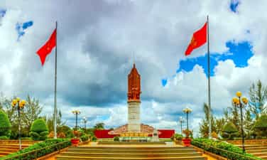
Pursuant to the Central Security Department of the Southern Department
In the war against the US to save the country, since its establishment in July 1960. The regional security committee is a agency under the Central Administration of the South, constantly clinging and building a base in the North Tay Ninh battlefield. After 15 years of fighting and maturing with 8 moving and building base. At the end of 1972, the Security Committee returned at Seven Bau, Tan Lap commune, Tan Bien district, Tay Ninh province until April 30, 1975. The relic area of the Central Security Department of the Southern Department has been ranked as a national historical monument in Decision No. 3777/Decision - The Head of December 23, 1995 of the Minister of Culture and Information (now the Ministry of Culture, Sports and Tourism). In the embellishment area, there are 32 beer houses of the security forces of the southern provinces from Quang Tri to Ca Mau. Each locality has a unique style, a unique symbol, depicting the specific traditional image of each land, but all focused and highlighted the hero of the word "Quan rang the mother of Quang Tri hero, to the indomitable Central Highlands, to Quang Da Trung as resilient. From Vung Ro connects waves to Dong Khoi's hometown Ben Tre, from Bac Hero hamlet to Kien Trung Hon, from Sac-Nha Nha forest to Binh Long, Phuoc Long built a victory. From U Minh, Dong Thap to Cu Chi steel soil to Dong, they all converge to Tay Ninh, where the seven Bau base was a time of resistance. ” This is a relic area, a quite attractive tourist destination, because the forest landscape of the war zone is preserved intact, the trenches, roads, houses have been restored and embellished in time with many beautiful works, especially the high monument blended into the vast forest tree space to create a majestic beauty depicting the glorious feats of the Southern Revolution. Source of the website of Tay Ninh province.
Tay Ninh
3671 view
Rating : National relics.

The souvenir souvenir to kill the US
The souvenir souvenir to the elimination of My Trang Lon is located in Chau Thanh town, Chau Thanh district, Tay Ninh province. Trang Lon was previously chosen by the US military to be built, both a military base and a logistics for many other bases such as Pan and Thien Ngon. From October 1965 to April 1972, this place is the base of the US Infantry Division No. 25, called "tropical lightning". Before the plot to expand the war of the US, Tay Ninh Provincial Party Committee advocated the establishment of the battle surrounding the base of Trang Lon base, forming a closed American elimination belt. The elimination belt of Trang Lon was one of the first three belts to kill the US first in the Southeast, including 8 communes surrounding the US 196 Brigade base. Born, existed and consolidated, developed, and the belt of destroying American Trang Lon has made battles consuming and destroying many enemy vitality. The belt of eliminating the big office is a creation, a feature only in the big party, has gathered the hearts of people, created the power of synthesizing the enemy with three armor, 3 zones, with three troops, creating many ways of fighting the enemy: fighting at the base, combining large fighting, beating, hitting continuously, always fighting, always struck, enemy waist, enemy feet. The belt of destroying Trang Lon and many other places in Tay Ninh province has promoted the great role and effect during the years the US sent troops directly to fight in Tay Ninh, contributing to clarifying a unique phenomenon, a form of creative enemy, a brilliant expression of the people's war. For Tay Ninh, this is also a symbol of the tradition of "Tay Ninh Trung Dung resilient". With 2,250 days and nights fighting on the belt of destroying the My Trang Lon (from October 1965 to April 1972), the Party Committee and the people of Chau Thanh district conducted 3,825 battles of Wei and Binh Dinh, making many glorious achievements, contributing to the whole country to defeat the "local war" strategy. The location of the Dai Trang Lon Kill belt has been ranked as a national historical monument in Decision No. 3990/Decision -The Culture and Sports Culture and Tourism on January 12, 2013 of the Ministry of Culture, Sports and Tourism. Source of electronic portal of Chau Thanh district, Tay Ninh province.
Tay Ninh
3771 view
Rating : National relics.

Cat Tien National Park
Cat Tien National Park was established on the basis of merging Nam Cat Tien forbidden forest, Tay Cat Tien Nature Reserve and Cat Loc rhinoplasty reserve, located in the area of 3 provinces of Binh Phuoc, Dong Nai and Lam Dong. The central area of the garden is 71,920 ha, of which, 39,627ha is located in Dong Nai province, 27,850ha in Lam Dong province and 4,443ha in Binh Phuoc province. Cat Tien National Park is a preservation area of many rare and precious animals and animals; It is an important area to maintain a wide -leafy green forest ecosystem - the only (current) living environment of a one -horned rhino in Vietnam, the Indochinese region as well as in the world. The coverage of natural forests in this area is up to 80%, with a diverse ecosystem: moist green forest, meadow and flooding. Natural terrain alternating with Bau, lagoons, streams, plus more than 90km of Dong Nai River has created a typical landscape for Cat Tien Garden, with rapids, waterfalls, flooded and semi -flooded areas, ... Geological traces, geography proves the transformation of nature in this area millions of years ago. Currently, Cat Tien National Park is one of the world biosphere reserves in Vietnam, has been enrolled by UNESCO. According to statistics, in Cat Tien National Park there are 1,610 species of plants and 1,568 animals. In particular, 31 species of plants and 84 animals named in Vietnam Red Book, 50 species of birds are prioritized to protect at the global level and are recorded in the IUCN Red Book, 2008). In particular, there are 3 species and endemic subspecies of Vietnam in the risk of destroying, namely black foot shank, one -horned rhino and Southern horns. Cat Tien National Park has been ranked national monuments in 1997. In Cat Tien area, there are many beautiful landscape locations, such as skyfall, Ben Cu waterfall, Buoi waterfall, Xoo waterfall, Neugrit waterfall - Mainrand ... One of the outstanding ecosystems here is the river system and the Bau. Dong Nai River, with a basin area of 40,800 km2; The section flowing through Cat Tien National Park is about 90km long. Dak Lua stream is about 20 km long, gathering water from the Bau to the river. Bau crocodile is the largest Bau, with an area of 92.63 ha. There are about 100 sapodilla crocodiles in Bau. This area is also home to famous lentils. Bau Ca is a natural lake, with a water surface of 74.3 ha. Bau Beo has an area of 23.92 ha. Around Bau is surrounded by many large timber trees ... In Cat Tien area, there is a fairly large meadow area, where preserving rare and rare animals (gaurs, holidays), well protected, almost no human impact. Regarding the flora of Cat Tien area: The highlight is the wide green forest, with an area of 17,819 hectares, where the plants are mainly belonging to the Dau family, such as oil, hair oil, ... Cam Lai Ba Ria, Cam Lai, Knot, Giang Huong, ... and large woods ...; Half -green forest is 5,097 hectares, including deciduous trees in the dry season, such as guava, shady, etc., large wood deciders and recovering in the rainy season; Bamboo intercropped wood forest has an area of 14,361 ha ...; Pure bamboo forest has an area of 29,805 hectares, formed under the impact of humans, with bamboo species, mum, bamboo (La Nga); Wet and semi -flooded vegetation has an area of 3,516 hectares, distributed mainly in the center of Nam Cat Tien. Archaeological traces show that in this area there has been an ancient culture. Historically, Cat Tien and surrounding areas are the residence space of many ethnic minorities: Ma, Choo, S’tieng, Mnong, Tay, Nung, H'Mong, Dao, Hoa, Muong, Ede, ... These ethnic groups still preserve many cultural activities, beliefs, special festivals, such as the sacrifices of the S’tiena and Sayang festivals, the new rice festival of the new rice festival (new rice) S’tieng and Mnong ethnic groups ... With the historical, cultural, scientific and aesthetic values of the monument, the Prime Minister decided to recognize Cat Tien National Park as a special national monument (Decision No. 1419/Decision -Prime Minister dated September 27, 2012). Source of cultural heritage.
Lam Dong
4210 view
Rating : Special national relics.
Ho Đeh Ho
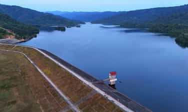
Located 10 km from the center of the district, Da Teh lake appears in the blue cover of the primeval tropical forest and the majestic O -mountain mountains. In 1990, Ho Da Teh was started construction. The Buon of the Ma people in the lake is relocated to a higher land right next to the lake. The large dam connecting the two slopes of the mountain has prevented the stream so that the water no longer flows meaninglessly but gathered to the Liu to rise to the lake. At that time, Ho Da Teh was the "3 most" irrigation project of Lam Dong province: the largest investment capital, the most complete irrigation project, bringing the highest economic efficiency. In 1997, Ho Da Teh completed became the largest irrigation project in Lam Dong province. The lake surface has an area of more than 100 hectares stretching to nearly 10 km, the widest place 400 m, containing 24 million cubic meters of water, covered with primeval mountains. The lake has brought water to irrigate more than 2,300 hectares of agricultural land to make green and rich fields in My Duc, Quoc Oai, Trieu Hai, Quang Tri and Da Teh towns, each day making the new countryside become a worthy countryside, making Da Teh district a new rural district in 2020 is one of the first 3 districts of Lam Dong "to finish" the new countryside. In the language of the people (the owner of this land), Da Teh means hot water (Đà: water, teh: hot). Perhaps, an area of the pan is surrounded and shielded by hills, so the climate here is hot, dry, the water flowing here has also become hotter than other places; Therefore, the whole land of sunshine and dust is called Da Teh. No more harsh heat, the cool water from the primeval forest makes the lake water all year round, both irrigating crops, and providing daily -life water for people in the district, Da Teh Lake also contributes to improving, changing the ecosystem and natural environmental landscape, regulating the environment, radiating cool steam to make the climate soothes, reducing the heat of the whole area. In 2004, Ho was recognized as a national landscape monument. Source of the website of Da Teh district, Lam Dong province.
Lam Dong
3997 view
Rating : National relics.

Elephant Waterfall (Lieng Rooa Waterfall)
Lieng Rowoa waterfall, also known as Voi Waterfall, is located in Nam Ban town, Lam Ha district, 25km southwest of Dalat city. Elephant Waterfall is one of the beautiful waterfalls of the majestic Central Highlands with a height of over 30m and about 15m wide. The old K'Ho villages residing in this land said: In the past, the chief of Jiu Bieng Mountain had a very beautiful daughter. Every time the female painted the voice, the forest leaves stop rustling, the birds stopped singing to listen. Her lover is the son of the chief of the village. He is loved by many people, not only because of his muscular physique, handsome face but also because of the bravery, brave, few people can match. They gave the promise so the husband and wife, but the boy had to set out to kill the enemy and then many moon seasons passed without seeing returning. The miserable girl came to the deserted mountain that they had dated before, singing earnestly and sorrowfully in the hope that the dream people to find the old place. The singing makes B'Ling birds touched. They invited each other to fly far away to detect the news and then let her know that the boy died on the battlefield. However, Son Nu still refused to accept that harsh truth. She kept singing, singing until she was exhausted, collapsed and never got up again. The elephant -covered herd listened to her singing for a long time. Suddenly there was a loud explosion, the sky and earth shook, causing the mountain to break and a stream of waterfall suddenly flowing, flowing white foam. The sound of the waterfall murmur and the rustling of the forest, the sound of the birds singing like continuing the lyrics, the sound of the beautiful and loyal female paint. The K'Ho people named the Waterfall Lieng Lieng Rooa Jiên Bieng - the waterfall of the elephants to restore stone before the passionate love, iron lipstick. It will be a pity to come to Da Lat - Lam Dong without going to Lieng Rooa (Voi Voi) mysterious and poetic. This waterfall is associated with this loyal and tragic love affair has been recognized as a national landscape. The clear water flowed through the marble mountainside to look spectacular, especially when the brilliant sunlight shone down the waterfall, making the rainbow seven colors. To get down the foot of the waterfall, visitors must "conquer" 145 steps of the races: When the stone steps "eat" into the climbing cliffs, when the planks of the beautiful wooden bridge are on the edge of the abyss. The sight is the thousands of forest with the old trees hundreds of years old, the stems and branches are interlaced with vines. In the middle of the vast gills, the green forest layer or dotted with bright red leaves like fire, bright yellow or purple carpets are strangely beautiful. At the foot of the waterfall and in the forest, some large rocks appeared like elephants. Therefore, the sound of the waterfall that made people enjoy it seemed like there was a herd of elephants racing or launching a fountain to play with each other. Behind the white waterfall is launching the dusty dust are deep caves full of mysteries. It is a bat cave that is ingrained to the ground up to 50m with cliffs with very strange shapes and colors. The roots and vines are interwoven, the deeper the cave is thanks to and cold as the witch's dynamic. It was a wind cave with a very narrow entrance but the inside was quite wide, soaring the flute of the wind. Besides the charming and poetic beauty, Voi Thac used to be revolutionary in the two wars against France - America. Newly embellished into tourist attractions in recent years. In 2001, Voi Waterfall was recognized as a national monument - a national landscape. Source of the electronic portal of Lam Dong province.
Lam Dong
3867 view
Rating : National relics.

Da Thien Lake - Valley of Love
Love Valley is one of the most poetic landscapes in Da Lat, about 5 km north of the city center, the Valley of Love has the address at 7 Mai Anh Dao, Ward 8, Da Lat City. It is the place where Da Thien Dam brings together small streams flowing from high hills and mountains, the clear and clear lake of the valley is shaded with green pine. In the 1930s, Governor -General of Indochina and French lovers often chose this scene for dating, then named Valleé D'Amour. By the time of King Bao Dai, this region was called Hoa Binh valley. In 1953, Mr. Nguyen Vy - Chairman of Da Lat Town Council at that time - proposed to change his name to the Valley of Love. Beautiful and attractive love valley by deep valley and pine hill all year round. In 1972, a block of water was built across the valley to form Da Thien Lake, increasing the charm of the common landscape, and appearing two other names besides the valley of love, Dam 3 and Da Thien 3. From here, the valley of love appears in a beautiful eye like a vivid picture. In 1998, the Ministry of Culture and Information recognized Ho Da Thien - Valley of Love was a national landscape. Source of electronic portal of Da Lat city, Lam Dong province.
Lam Dong
3791 view
Rating : National relics.

Lang Bian Mountain
Lang Bian Mountain is located in Lac Duong district, 12km north of Dalat city center. This is a suitable place for ethnologists, for tourists who love traditional culture to cultural research of the ethnic groups of the South Central Highlands. Lang Bian Mountain is also known as Mother Mountain, including 2 tops, with an altitude of 2,167m. The old story said that there was a couple of talented and loving boys and girls in love with each other - K'Lang and her Ho Bian. Due to the curse of the two tribes, the two had to separate. She after death transformed into a mountain range that the Ho-Lach ethnic group called the mother mountain and milk from her breasts has flows into the fresh streams and waterfalls for life. Since then, the two mountains have been named Lang Bian. Lang Biang Mountain, also known as Ba Mountain with a height of 2,189m of the legendary Bidoup series, has long become a regular destination for visitors. Langbiang mountain is also famous for its legend associated with the history of the indigenous people about the famous Heavenly History of Lang and Biang. Since 2004, the Ministry of Culture and Information has recognized Lang Biang as a national landscape monument. Source Department of Culture, Sports and Tourism of Lam Dong Province
Lam Dong
3928 view
Rating : National relics.

Prenn waterfall
Prenn Waterfall is a waterfall in Da Lat city in Lam Dong province. Prenn Waterfall is located next to Highway 20, at the gateway to Dalat city is one of the eco -tourism areas of forests and streams. Waterfall at the foot of Prenn pass is about 10 km from the center of Dalat. The waterfall is located in the remaining primeval forest. The water from the rocky rapids with a height of more than 20m high poured into white like a strip of white silk looks like the hair of the White Mao Tien. Maybe so that some tourists call Tien Sa waterfall. Prenn waterfall originates from Prenn stream, originating from the area of shrimp pit, Bao Dai stream (valley after palace 1 - Da Lat). Prenn stream is also known as the Prenn and Prenn Waterfall, also known as Liang Tarding. Coming to Prenn Waterfall, visitors can visit, entertain and visit Au Lac temple, King Hung temple in Lam Dong province. The legend of Prenn Waterfall is also associated with the development history of the Cham dynasty in the seventeenth century of the Poôme dynasty (1625 - 1651). Since 1998, Prenn Waterfall has been ranked by the Ministry of Culture and Information. Source Department of Culture, Sports and Tourism of Lam Dong Province
Lam Dong
3826 view
Rating : National relics.

Cat Tien archaeological monument
Cat Tien Archaeological Site is a complex of brick architectural ruins with a very large scale, stretching about 15km according to Ta Ngan Dong Nai River from Quang Ngai commune to Duc Pho and Gia Vien communes (Cat Tien district - Lam Dong province). Archaeological excavation results (from 1994 to 2006) many architectural ruins of temple tower, tomb, long house, water trough system, ancient rocky roads, ... have been revealed. The architecture here is large and small, depending on the function, with square or rectangular plots, the main door turned to the east. The excavation process has found more than 1,000 artifacts including many materials such as gold, silver, copper, gemstone, ceramic, ... rich in type such as: idol Linga - Yoni, Ganesa, UMA god, rings, chain seeds, floating gold leaves of the gods, Balamon mascots. Through the type of architecture, the artifact is found that this is a religious mecca influencing the Indian religion and the trace of a unique culture in the past. Cat Tien Archaeological Relic is a big finding of Vietnamese archeology in the late twentieth century, which is important in studying ancient cultures in the South and the Central Highlands. Archaeological excavations show that Cat Tien culture has a fairly long development process: the early period around the fourth century - VI and the late period of the Seventh - 10th century AD. Especially, the development process of Cat Tien culture has a close relationship with the Champa culture in the South Central Coast and Oc Eo - Oc Eo culture of the Southern Delta of Vietnam. In the opinion of the late Professor Tran Quoc Vuong in the scientific conference of Cat Tien archaeological monument, (March 2001) concluded: “This relic has many unique native elements (endogenous) and also has many external factors (external - exogenous). The external factors saw from the southwest are Chan Lap and from the Northeast is Champa, including physical and formless culture. It is possible that the cultural elements are slightly inclined to Chan Lap and the inhuman elements are inclined to the Champa. Therefore, this monument is "standing between and it is itself". Cat Tien archaeological relic is located in the middle of the provincial road 721 connecting Highway 20 (Madagui junction - Domhuoai district - Lam Dong province) with Highway 14 (Sao Bung junction - Bu Dang district - Binh Phuoc province). The relic center is located on the north bank of Dong Nai River close to the core area of Cat Tien National Park, about 190km from Da Lat (north) and Ho Chi Minh City. Ho Chi Minh City is about 180km (south), this is a pretty location on the tourism map, very convenient for tours from Ho Chi Minh City, Da Lat and the Central Highlands provinces to visit. Cat Tien Archaeological Relic is also known as the Holy Land of Cat Tien, which preserves the evidence of a unique culture more than 1,000 years ago. With the wide scene of the monument and a rich number of artifacts and special values such as the floating yellow leaves shaped by the gods, the Balamon religion and the collection of Linga - Yoni of gold, copper, stone, gemstones ... including the giant Linga - Yoni idol is identified as the largest in Southeast Asia (compared to the relics of the same quality). In addition to the Cat Tien archaeological site in Cat Tien district, visitors can also visit the historical and resistance relics of the Party Committee of the Vi area and some living points of the Ma people and the long -standing indigenous people who have been living on this legendary land. Cat Tien Archaeological Archaeological Area bears the indigenous culture, but still shows the absorption of the quintessence of other cultures throughout the historical length from the fourth century to IX. It is associated with an organized and large -scale ancient community, with a unified and tight socio -economic system with high levels of development (the most convincing evidence is the appearance of writing on golden pieces). The formation and development of the monument plays an important role in the historical process of the South Central Highlands - Southeast. With a special special value, Cat Tien archaeological monument (Cat Tien district, Lam Dong province) was ranked as a special national monument by the Prime Minister (in Decision No. 2408/Decision -Prime Minister dated December 31, 2014) Source of cultural heritage.
Lam Dong
3959 view
Rating : Special national relics.
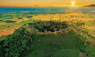
B’lang volcanic landscape
B’lang volcano (also known as Chu R’luh volcano), in Buon Choah commune and Nam Da commune. This is a volcano formed in the final stage of Geological Development History - Global Geological Park (CVDCC) UNESCO Dak Nong. This is the only volcano in Dak Nong Geological Park to create the lava cave system, the most large and unique in Southeast Asia. According to the survey, research by scientists, the process of operating lava lines from the b’lang crater flows in all different directions (Northwest, Northeast, Southwest and Southeast). Up to now, 4 cave systems have been detected, including 50 caves with distribution characteristics and mechanisms to form a cave, rich and diverse cave doors and beautiful. There are many caves distributed in the shallow floor, but there are also many cave distributed in the deep floor tens of meters. B’lang volcano, distributed at an altitude of about 601m above sea level with a depth of the crater is about 59m. The mountain axis is about 160m long, short axis about 100m; The crater area is about 4 hectares, the volcano area is about 1.6 km2. B’lang volcano area is located near carbon, rich in cultural traditions of the M’nong and Ede ethnic groups ... With traditional festivals, professions and cultural and scenic historical sites, the ranking has been ranked favorable to connect tours, tourism routes, exploit and develop tourism in the future. On March 12, 2024, the Ministry of Culture and Sports -Lich issued Decision No. 611 of the national monument ranking for B’Lang volcanic landscape, Buon Choah commune and Nam Da commune. Source of electronic portal of Krong No district, Dak Nong province.
Lam Dong
4107 view
Rating : National relics.