Relic point Vietnam
Việt Nam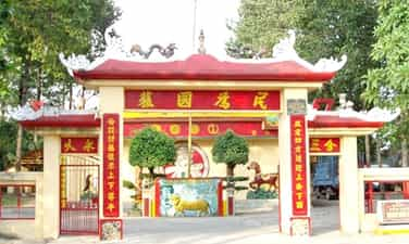
Tombs, temples of Doan Van Cu and 16 Nghia Binh Thien Dia Hoi
Mo Do Doan Van Cu and 16 Nghia Binh Thien Dia Hoi is located on the Binh Dia area of Long. Binh, Long Binh Ward, Bien Hoa City. This is the burial place of Doan Van Cu, the leader of the Heavenly Association in Bien Hoa and 16 Nghia Binh stood up the resistance against the French army. The temple has a beautiful architecture, including the Vo Ca and the main hall, which is a place to commemorate and pray for Doan Van Cu and his soldiers. The tomb and temple of Doan Van Cu were ranked by the Ministry of Culture and Information of the National Cultural and Cultural Monuments in Decision No. 722/Decision -The Culture and Sports Culture on April 25, 1998. The monument consists of two parts: tombs and temples. The tomb is the burial place for the patriotic house Doan Van Cu, the closed leader of "Heaven and Earth" in Bien Hoa and 16 Nghia Binh Tu battle in the attack of France to carry the palanquin in 1905. This is the place where the resistance base of the "Heavenly Earth" of Bien Hoa. The tomb is located on Binh Dia area, close to the Linh Tuyen stream, about 8 km from the center of Bien Hoa city. Initially just a simple burial tomb; In 1956, the local people were re -built but small scale, until 1990 the new tomb was built like today. The rectangular tomb is 16.5 m long, 2 m wide 0.75 m high, behind is a small temple to worship Doan Van Cu and 16 Nghia Binh. The tomb area is protected by two brick fences, with an entrance, almost surrounding the tomb is the Linh Tuyen stream. The communal house was also built in 1956, about 1km from the tomb to the northeast. The temple is located on a flat, nearly 3000 m2 land area, in Tam Hiep ward, on Highway 15. The temple is built according to Tam Tam architecture (/) consists of two main parts: Vo Ca and the main hall. The martial artist has an area of 303.75 m2 opposite the main temple. Inside there is a small stage used to sing bumper during holidays. A stage opposite the main hall. Before entering the main hall, he had to go to Bai's house. This is the place where the cross goes in and out of the ceremony. Following Bai's house is the main hall; Behind the main hall is a guest house and a kitchen. Doan Van Cu was born in 1835 in Binh An village, Binh An district, Bien Hoa province (now Thu Duc district, Ho Chi Minh City) in a patriotic Confucian family. He led the Heavenly Heavenly Association in Bien Hoa, a patriotic organization against the French. He gathered a large number of insurgents to conduct the resistance war against the French (before the Communist Party was born). In order to prevent the effects and extinguish the movement right from the egg, on the morning of April 12, 1905, a Ma Ta soldier platoon was pulled down by the Sen Dam, the besiege of the palanquin base. The name of Quan Ba and the group of soldiers crossed the stream. At the same time, there was no military guarding the French enemy massively attacked. Doan Van Cu was hit by a sacrifice in front of the altar to worship 16 Nghia Binh. Later, the local people buried him and 16 Nghia Binh and a tomb. Although the time has passed, the fierce example of Doan Van Cu and 16 Nghia soldiers is still a shining example of his love for his sacrifice and the military soldiers who are forever recorded and remembered forever. Source of cultural heritage.
Dong Nai
4156 view
Rating : National relics.
Mo Nguyen Duc Ung and 27 Nghia Binh against the French
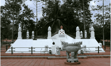
From the Vung Tau junction, along Highway 51 connecting Bien Hoa city with Ba Ria - Vung Tau province, the tomb of Leader Nguyen Duc Ung and 27 Nghia Binh against the French is on the left, about 250m from Highway 51, about 7km from the center of Long Thanh district to the south. The monument is the result of the reconstruction in 1936 and the restoration and embellishment later. After restoration and embellishment in 2010, Nguyen Duc Ung's tomb and 27 Nghia Binh were located on a high land area with a total area of 27,402m2, the area in the existing fence was 3,837m2 (of which the construction area was 1,262m2), the land area created a reverse construction space was 4,571m2 and the land leaving the road next to the land area of 570m2. The tomb area has the following location: North borders: Melaleuca land, bamboo bamboo and garden houses. Male: Bordering National Highway 51. East Giap: Melaleuca garden and rice field. Western Giap: Trail - The road traveling in Long Phuoc commune. Overall, the whole grave area is arranged in a main axis, taking the tomb of Nguyen Duc Ung to Highway 51 to form the land with a width of 65m, divided equally on both sides along the main axis. The overall tomb area is arranged in five areas with the following location: Tam Quan gate, reception area: 5,204m2, souvenir tree planting area: area of 2,084m2, Beer house area, Temple: Area of 6,438m2, Main tomb area: Area of 6,502m2. Lanh Binh Nguyen Duc Ung and 27 Nghia Binh sacrificed in the fight to fight the French invading troops on December 26-27, 1861. After Nguyen Duc Ung and his heroic troops sacrificed, the people of Long Thanh sought to bring his corpse and the army of burial in the grave on a high land of the primeval forest, even his French resistance base in Long Thanh commune (now Long Phuoc commune, Long Phuoc district). According to the traditional feng shui concept, the tomb is located on the mound -shaped mound, the sand position, good effects on the settlement of the people residing in the area. Also from here, this land became a place to rest for his thousand years and the soldiers sacrificed for the Fatherland, which could be considered as the first martyrs cemetery of Long Thanh district. Mo Nguyen Duc Ung and 27 anti -French militants were restored in 1936, 1996 and 2010. Architecture built in the overall land in accordance with the general orientation, highlighting the idea of "the martial arts house". The roof of the beer house and the temple bearing the typical roof of Hue royal court, the Nguyen Dynasty. With that value, the tomb area of Nguyen Duc Ung and 27 anti-French military relics has been ranked national historical monuments under Decision No. 2754-Decision /Minister of October 15, 1994. Source of websites in Long Thanh district, Dong Nai province.
Dong Nai
3985 view
Rating : National relics.

Bien Hoa ancient citadel
Located in Quang Vinh Ward, Bien Hoa City, Dong Nai Province. This is considered the only ancient city in the South to exist today. The remaining vestige of the old city is a ring built of laterite surrounding the area of 10,816.5 m², inside there is a French architectural house. Bien Hoa Ancient Citadel also has other names, Cuu, Thanh Trump or Thanh Gas, ancient Thanh Lan village (Tan Lan), Phuoc Chanh district, Bien Hoa province. Initially, Bien Hoa citadel was covered by the people and soldiers of Chan Lap in the 14-15 century. After that, at the beginning of the Nguyen Dynasty, in 1834, King Minh Mang rebuilt with soil, bricks and laterite, in the shape of the bow, building a number of new items, named Thanh Cuu. In 1837, King Minh Mang continued to build and expand into a former laterite of Vauban style, renamed Thanh Bien Hoa. Realizing that the strategic geographical position of Bien Hoa citadel, the French colonialists gathered powerful troops to occupy this citadel. In 1861, the French colonialists conquered Bien Hoa. The Nguyen army was not successful, so he withdrew from Bien Hoa citadel. After occupying the city, the French colonialists have embarked on renovating and narrowing the remaining area of 1/8 compared to before; At the same time, the construction of security and military facilities inside and outside the city, such as: barracks, merchants, military security departments, training grounds, shot beaches, cells, working rooms ...; Arranging high -ranking officers, soldiers to keep, protect and work during the period of colonial rule, colonial exploitation and called the petrol - stone (sola), the local people often called the trumpet. In 1944, Thanh was in control of Japanese fascists. After returning to Indochina for the second time, France used this place to build a family farm. By the period of 1954-1975, Thanh did not have many changes in appearance, the American empire used all the works left by the French colonialists. After 1975, Bien Hoa citadel was taken over by the new government. The remaining traces at Thanh Bien Hoa relic today stand out, the citadel was built of laterite and two French architectural houses. Specifically, the remaining items include: The wall of the city is built mainly from red laterite, tiles with adhesive is lime. The blockbock system currently has a number of bunkers built of laterite and tiles in the eastern corner. The northwestern villa, one of the remaining items of the ancient Thanh Bien Hoa architectural work including 1 ground floor and 2 floors built in the style of French architecture used as the residence and work of French officers. The villa has a solid architectural structure with bearing walls, roofed roofs, steel purlin roofs combined with wooden bridges, tiled floors, brick -rolled linen, ventilated roof doors are done with art aesthetics, technical ingenuity, ensuring good strength for the project. The southeast villa with an area of about 200m2, including 1 ground and 1 floor, used as the residence and work of the French officers at that time. Today, after the last restoration in 2014, the overall monument has become spacious, becoming a sightseeing place to attract tourists from near and far. Experiencing the ups and downs of history, Thanh Bien Hoa relics are witnesses for many events and events in the history of Bien Hoa - Dong Nai. Starting from the fighting between the Kingdoms of Funan, Chan Lap, Cham Pa (1st century) to the war between the Nguyen Dynasty and the Tay Son army (eighteenth century) and later the struggle to defend the country of our people against the French colonialists and the American imperialism. At the same time, this is also considered a rare ancient city project that still exists in the Southern region to this day. In addition, the monument is valuable in many aspects when it is both a special military architecture and a strategic position in the Southeast region of the Nguyen Dynasty; Just reflect the technique of building scientific and architectural lines in the overall items exist. At the same time, show the knowledge of feng shui in the geopolitical way of the ancients. With these historical values, the Ministry of Culture, Sports and Tourism issued Decision No. 3995/Decision -The Culture and Sports Culture and Tourism on November 12, 2013 to recognize Bien Hoa Citadel as a national historical monument. Source of portal port of Bien Hoa city, Dong Nai province.
Dong Nai
4318 view
Rating : National relics.
Tran Bien Temple
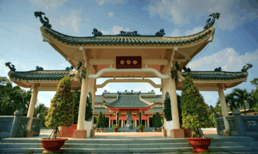
Tran Bien Temple is currently located in Buu Long Ward, Bien Hoa City, Dong Nai Province. The history of Tran Bien Temple is associated with the opening of the southern world of the Nguyen Lords. In 1698, Lord Nguyen Phuc Chu sent Nguyen Huu Canh to the Kinh of Dong Nai and merged this land into Vietnam. 17 years later, in 1715, Lord Nguyen Phuc Chu built Tran Bien Temple of Literature, to show the thought of honoring Confucianism, promoting the tradition of respect, respectful talent and continuing the Vietnamese cultural tradition in the South. The work had twice the major restoration was in 1794 under Lord Nguyen Phuc Anh, and in 1852 during the King Tu Duc. In 1861, the French colonialists conquered Bien Hoa and broke this project. It was not until 1998 - to celebrate the 300th anniversary of the establishment and development of Bien Hoa - Dong Nai; Tran Bien Temple of Literature has been restored on the old ground with an area of about 5 hectares, of which the main altar is 2 hectares and completed construction after 4 years. Tran Bien Temple of Literature was restored according to ancient documents such as Dai Nam unanimous, Gia Dinh Thanh Thong Chi. The work items are built symmetrically according to a god axis; In turn, from the outside are Van Mieu Mon, Beer House, Khue Van Cac, Ho Tinh Quang, Dai Thanh Mon, Confucius statue, Ceremony yard, main church. The two sides have the description - Huu is the name of the name - the traditional house, the loincloth - the writer of the loincloth. The building is built with new materials but still follows the traditional style. On Khue Van Cac can see the whole complex of the building. The round door is symbolic for the star Khue (similar to Khue Van Cac in the Temple of Literature - Quoc Tu Giam Hanoi) has been recreated in the Temple of Literature Tran Bien. Behind Khue Van Cac is a wide lake named Tinh Quang. The works here are roofed with Thanh Luu Ly tile (turquoise enamel tile). The works have a harmonious layout. Alternating between constructions is a green tree and many ornamental plants, and the water creates an airy space. Next, after the Tinh Quang Lake is the Great Monk. This is a typical architectural item of the Temple of Literature, leading to the main altar. Dai Thanh Mon has a triangle architecture, tile roof; The two sides have brick walls. After Dai Thanh Mon is the Confucius statue - the ancestor of Confucianism, placed under a roofed architecture, followed by the ceremony and the main church. Confucius statues are carved in monolithic stone, made according to the form from the World Heritage Site (Shandong Province, China). The church is a 7 -space architecture, two wings with 3 floors; There are many ethnic details, inside the columns, trusses and blue, diaphragm and sentences painted with gold. This is the place to worship Vietnamese cultural celebrities. The front is a large yard for ceremonies and organizing cultural events. In the middle of the church is the place to worship President Ho Chi Minh. The left space is the place to place the taste and worship the cultural celebrities associated with the land of Bien Hoa - Dong Nai and the ancient South; On the right is the place to place the tablet and worship the typical cultural celebrity of Vietnam. In front of both sides of the church are: Van Lo Lo (where to display 4 traditional craft villages of Bien Hoa - Dong Nai: Copper, carpentry, stone, pottery); Published for writings is a loincloth - a place to display ancient bibliographies, documents, books ... written about the history, culture, people of the land of Bien Hoa - Dong Nai in the past and present. On August 18, 2016, the Ministry of Culture, Sports and Tourism made a decision on national ranking with historical relics of Van Mieu Tran Bien. Tran Bien Temple is a special cultural address in Bien Hoa (Dong Nai). With airy space and unique architecture, bold cultural tradition, studiousness; This place is the organization of many local events such as students for students, spring flower festivals, spring newspapers, poetry festivals, public newspapers, ancestors' visits ... This is a place to preserve, preserve and honor traditional values, a place to commemorate Vietnamese ancestors in the South. Source of portal port of Bien Hoa city, Dong Nai province.
Dong Nai
4475 view
Rating : National relics.
The relics of the Binh Association first
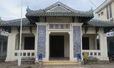
The previous Binh Association relics belong to Binh before, Bien Hoa city, Dong Nai. This was a special architectural work of the village's village of the village before 1945. The Association was built around 1936 under the policy of the Governor of Bien Hoa Province Bolen. The previous association has become a meeting and working place of the local Qii. Located near the city center, the Binh Hoi house first attracted attention with folk architecture. Built by the artisan of pottery and construction of Bien Hoa, this monument stands out with sophisticated wooden sculpture and architectural works, reflecting the beauty of traditional Vietnamese art. Although it is not a temple communal house, the previous family still shows the solemn and unique features of the village architecture, combining many characteristics of the Nguyen Dynasty architectural art. With an area of 187.50m2, the architecture of the Association has yin and yang tile roofs, wooden decoration and sophisticated ceramic reliefs. More specifically, the previous Binh Association also marked an important event in Bien Hoa history. On September 23, 1945, the Bien Hoa Provincial Officer Conference decided to establish the first Provincial Party Committee after winning the government in August. This is one of the important events preparing for the resistance against France. The previous Binh Association relic was recognized by our State as a national cultural and historical monument on December 30, 1991. Source of Dong Nai Electronic Portal.
Dong Nai
3980 view
Rating : National relics.
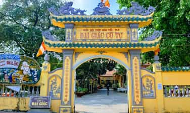
Dai Giac Pagoda (Dai Giac Co Tu)
Dai Giac Pagoda is also known as Dai Giac Co Tu, Big Buddha Pagoda or Tuong Pagoda; formerly belonged to Binh Hoanh village, Hiep Hoa commune, the Governor of Bien; Now is Nhi Hoa Quarter, Hiep Hoa Ward, Bien Hoa City, Dong Nai Province. Dai Giac Pagoda has an area of about 3,000 m2 with two gates built of bricks in and out, surrounded by fences. After many restoration, the pagoda is now in the way of Tam (三 三) with three horizontal houses connecting each other. The front of the pagoda rotates in the Northwest direction overlooking the Dong Nai River. In the middle of the pagoda, it was a large Bodhi tree, planted by Venerable Dinh Tong on the full moon day of November of the Year of the Rabbit (1939) and the statue of the Nam Hai Buddha stood on the lotus. On the left and behind is a large garden planting fruit trees, the right side is the stupa area with many tower tombs of the abbot. Although outside, the temple awnings are low and have modern architecture, but inside the temple, there is still a model of the ancient temples in Dong Nai, with round and towering columns, creating an open space. The pagoda includes the main hall, guest houses, monks, boys and kitchen. The main hall is a large three house, used to worship. Mid-space: On the top is the Buddha image of Amitabha of 2.25 m high, the bottom is the Buddha Shakyamuni Buddha and Buddha Di-Lat. The nearby door is a pharmacist Buddha lamp consisting of 49 small oil lamps with 49 small wooden Buddha statues, foot and trusses that carved very well. The left space is Khanh worshiping the Bodhi-Bodhisattva ancestor. On the right is Khanh worshiping the Emperor Quan Quan. On both sides of the wall, each side worships the five Kings and two judges. Behind the main hall is the altar of the ancestors who have been propagating at the pagoda, including many of the long-term Zen masters, including the oldest of the oldest monks who are Zen Master: Thanh Dang (Lam Te 34), Italian-Linh Nhac, Lieu-Tham Truyen (35), Indian Hoang Hoang (generation 36) ... Connected to the main hall of the Palace, the Buddhist worship ... Dai Giac Pagoda, along with Buu Phong pagoda and Long Thien pagoda, are three Vietnamese religious architectural works, built the earliest in Dong Nai and is the testimony for the Nam Tien road in the first half of the 17th century of the three monks of Lam Te in Dang Trong. In addition to this value, at Dai Giac Pagoda, there are Buddha statues, diaphragm, tangi, reliefs ... with many rich topics, elaborately carved, painted golden cards. All have shown the engraving talent of the creator and reflect more or less traditional art of the Southeast. With the above values, Dai Giac Pagoda has been ranked as a national historical and artistic monument under Decision No. 993/Decision, signed on September 28, 1990. Source of Dong Nai Electronic Portal.
Dong Nai
4041 view
Rating : National relics.

Pagoda archaeological ruins
The historical site of the temple is a national monument ranked in 2001 (Decision 53/Decision -The Culture and Sports Culture on December 28, 2001), located on the banks of Dong Nai River, on the inter -provincial road road Tan Uyen to Lac An, Tan Hoa hamlet, Tan My commune, Bac Tan Uyen district. Through excavations have formed many collections of artifacts with great historical and scientific value. Stone, ceramic, bronze, ... Especially a collection of 76 copper molds and 68 copper weapons tools discovered in the monument. Pagoda slope became an important collection of artifacts for a peak of development of the prehistoric period of the Southeast region. A diverse and rich monument has many new factors, the economic and technical convergence of society develops high, dating from 2500 to 3000 years today. In particular, there is an animal statue recognized national treasures. Source of portal port of Binh Duong province.
Ho Chi Minh City
2849 view
Rating : National relics.

Archaeological monument of Cu Lao Rua
Turtle island in Thanh Hoi ward, Tan Uyen town, Binh Duong province. Ranking the National Monuments in 2009 (Decision No. 836/Decision -The Culture and Sports Culture on March 3, 2009). The relics dating to two stages (early from 3500 - 3000; late 3000 - 2700 years today). The total area of 277 hectares, height of 15m above the area. This is one of the first discovered archaeological sites in the Southeast, through archaeological excavations discovering Cu Lao Rua is the resident - burial relic area, with many stone, pottery tools and thousands of broken pottery pieces of all kinds and many burial tombs. Over 100 years of research, Cu Lao Rua has made an important contribution to preserving prehistoric cultural heritage and landscape of Binh Duong province. Source of portal port of Binh Duong province.
Ho Chi Minh City
2793 view
Rating : National relics.

Ancient house Tran Cong Vang
The house is located at 21, Ngo Tung Chau Street, Phu Cuong Ward, Thu Dau Mot Town, on a land area of 1,333m2, especially the main part (upper house) is 323m2, auxiliary house (lower house) accounting for 119m2, built and completed around 1889 - 1892. The house was recognized as a national monument on January 7, 1993. The house turned to the South, his back leaned against the hill (where the provincial People's Committee headquarters now), this is also a favorable position, according to the ancient feng shui. In terms of geographical location of the Golden House as well as two old houses of the Tran family in Phu Cuong ward are located near the Saigon River, very convenient for transporting timber trees from the forest. It is known that the ancestor of Mr. Vang used to work as a forest, with a saw and sawn wood. The building is built according to the architecture of Dinh Noi, that is, the horizontal house is on the left of the house, instead of being on the right. This is an improved nail house, there is a part that separates the upper and lower house, the contact between the two parts of a small bridge cut the child's yard to make the two door parts of the lower house in the tip of that yard without blooming at the gable, this door is also specially architecturally, looking like some Chinese temple gates, but the owner has launched in the temple style of India. Like many other houses, the Golden House has a frame in the style of a cross, but there are 8 punches, 8 decisions in the two wings. The set of treasures, treasures, mortars are skillfully peeled, finished bending and creating ledges, the trusses are meticulously and meticulously touched, the leaves are straight in the third column. The whole house counted 48 round pillars, all stood far away. The decoration inside the house is the most interesting visitors, which is the elaborate carved, from the foot of the column to the roof, tables and chairs of chairs, worshiping the door frames of the cage ... Hoanh Phi, Lien, opposite, the paintings of the four jars, the players ... all are carved, painted with elaborate nacre nacre skillfully, making the house magnificent but solemn. In general, the carved motifs here are often estimated, symbolic, which expresses the desire to a peaceful, happy life, and a human life, morality ... The lines focus on flexibility and softness. The carved images include plants, flowers, birds, items, geometric roads. Particularly, the player hanging on the right altar from the inside to look at Tung Loc, Ma Duong has two verses of Chinese characters to create an elegant, elegant and pepper look. Distribution of the ground of the house, first of all the house, the house has 5 spaces of two wings, the worshiping part, receptions, the rooms to live and store the furniture of wealth are clearly divided. The worshiping part occupies three compartments based on the principle of the left space of the home of the host, the right to worship grandparents, the altar between worshiping grandparents is higher than being a fairy. Each altar consists of a nacre altar, above is a five -piece map, inside is a taste or portrait of the deceased, close to the silk wall is the worship, on the top, the opposite sentence, the head of the church somewhat touched "Mesopotamia of Chau Chau" and the player. Two spaces on both sides are the bedroom of the owner, behind the wall of the altar is the chamber containing furniture ... On the altars are the worshiping pages that have placed the articles, the Holy Emperor, the Earth, the East Tru, the Destiny, the Holy Spirit, the Fortune. The reception of guests consists of two base hearts (ie from the second to the fourth column column), this place has tables and chairs to receive guests, including in the middle of a large round table, marble lined table surface, on the table, the bowl of Buu bowl (eight antique weapons), around the table, there is a chairs with sophisticated carvings and rich symbolic meanings. The two sides of the round table are rectangular tables in the style of a chairs. At the beginning, there are two mango box -shaped tables, surrounded by modern chairs, all the tables and chairs are wooden. Along the partition between the reception and the church, there are small square tables above with porcelain dishes, and the owner here puts a genealogy to generalize the things of the people of them. At the two ends of the house, there are also places, on the left on the altar for the owner, there are couples on both sides, small quartet paintings, couplets and quartet paintings. In particular, the front of the bedroom placed a glass cabinet, inside contained many precious dishes such as neck money, sports hats, clothes for the bride when returning to her husband's house, in the old way ... The lower house was a horizontal house, stored in a transparent way but simpler than the upper house. Horizontal houses are used to receive ordinary guests, a place for family activities, cafeteria, kitchen, ... in front of the horizontal house is the garage towards the gate door. The front yard planted many pots of ornamental flowers, ornamental plants ... Add the ancient beauty of the house. The Golden Instrument is both artistic - humanistic bold Vietnamese traditional culture; At the same time, affirming the sculpture and carved technique has a long tradition in Binh Duong. Decorative artifacts and household items are still many and most are antiques. The entire architecture of the house and artifacts inside, showing us the activities of the rich family in the late 19th century, showing the development of the lives of Vietnamese residents in Binh Duong. Source of portal port of Binh Duong province.
Ho Chi Minh City
2829 view
Rating : National relics.
The relics of Duong Minh Chau base
Duong Minh Chau relics are located in Phuoc Ninh commune, Duong Minh Chau district, Tay Ninh province. Duong Minh Chau is the name of the Chairman of the Administrative Resistance Committee of Tay Ninh Province, who sacrificed heroic in the battle of France to Ben Cay Cho Ben Ben (now in Go of Hamlet, Ninh Dien Commune, Chau Thanh District, Tay Ninh Province). On February 7, 1947 to engrave the gratitude and commemorate comrades, the province took the name Duong Minh Chau to name the base. The policy of building a base, a place to stand to build a forces for the long -term resistance war, has been posed quite early by Tay Ninh province, from the early days of preparing to revolt Nam Ky. In 1948, due to the requirements of the provincial resistance war, he decided to choose the tea area as a base of the province, including zone 4, zone 6, adding the land of Ninh Thanh, Hao Duoc and Hoa Hiep communes. During the resistance war against the US to save the country, in the face of the new task, Duong Minh Chau base continued to expand and develop widely to the northwest and north of the Cambodian border. Duong Minh Chau base has a terrain location that is considered an important strategy, converging the properties of three strategic areas, in which the mountainous area occupies a special position, can be continuous at the back, a large forest area to eat up to the Cambodian border, closely related to the war zone D. This mountainous area is eligible for "heavenly, geography, harmonious people" to build a base of the base of the base, the base of the resistance and the resistance system Advantages with the command and direction of the entire resistance war. Duong Minh Chau base is like a thorn that stabes the enemy's eyes. The enemy was "pacified" and "destroyed", and we were determined to protect and maintain the "holy land", the district base Duong Minh Chau and other base areas were both rear and a hot strategy, struggling between us and the enemy during the resistance against the US from the local war, Vietnam turned the war. In the Ho Chi Minh campaign, Duong Minh Chau base is one of the gathering places of the main force to advance to liberate Saigon. In the world, the speed of the army and people of Duong Minh Chau and the Tay Ninh army liberated himself, contributing to the end of the victory of the resistance war against the US to save the country. Duong Minh Chau base relics have been recognized as a national historical and cultural monument in Decision No. 61/1999/Decision - September 13, 1999 of the Ministry of Culture and Information (now the Ministry of Culture, Sports and Tourism). Source of the website of Thanh Tan commune, Tay Ninh province.
Tay Ninh
3842 view
Rating : National relics.