Relic point Vietnam
Việt Nam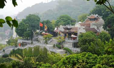
Cua Ong Temple Historical Relic
Cua Ong Temple (also known as Dong Hai Linh Tu or Duc Ong Temple) is located in Cua Ong ward, Cam Pha city, Quang Ninh province. The temple worships the main deity, Quoc Khao Hung Nhuong Dai Vuong Tran Quoc Tang, in addition to worshiping Cuu Thien Vu Empire Phu Nhan Vu Hung Dao Dai Vuong and his family and generals. Through historical records, it can be confirmed that Cua Ong Temple was built and existed for more than 100 years. At the beginning, the temple was just a small hermitage made of thatch, bamboo, and leaves; In 1907 - 1916, the temple was restored; In 1916, the Upper Temple, Middle Temple, Lower Temple, and pagoda were built; In 1946, the Lower Temple and Upper Temple continued to be renovated and embellished; In 2014, the master plan of the Cua Ong Temple relic site was approved with an area of 18,125 hectares; By 2016, Trung temple was built and completed in 2017. In addition, there is also Cap Tien temple (people call it "Cua Suot Girl" temple) built during the Nguyen Dynasty. Cua Ong Temple was initially built to worship Tran Quoc Tang, after building additional Ha, Trung and Thuong temples, Cam Son pagoda... specifically as follows: Ha Temple area: includes Mau Temple and Trung Thien Long Mau Temple Mother Goddess Temple: worships three thrones of the Holy Mother (Mother Thuong Thien, Mother Thuong Ngan, Mother Thoai Phu), Jade Emperor, Nam Tao, Bac Dau, Four Adoring Her, Five Worshipers, Mr. Hoang Muoi, Mr. Hoang Bo , Mr. Hoang Bay. Trung Thien Long Mau Temple: worships Trung Thien Long Mau and worships three girls, Cua Suot boy and Cua Suot girl (two people like Kim Dong and Ngoc Nu, symbolizing yin and yang who always follow and protect the mother, protect the land and waters of Cua Suot, protect the temple where Trung Thien Long Mau is located). Currently, Cua Ong Temple still preserves the ordained religion for Cam Pha commune, Hoanh Bo district, Quang Yen province, worshiping Trung Thien Long Mau deity, dated March 18, the 2nd year of Khai Dinh (1917). The stone stele at Ha Temple was built in the year of the Rat (1948). Trung Temple area: worships Kham Sai Dong Dao Tiet Che Hoang Can, who was instrumental in suppressing foreign invaders from the North and defending the East Sea. Here, the Son God and the Water God are also worshiped because Trung Temple is located on the Cam Son mountain range, in front of the East Sea, people in the estuary area as well as boats passing by pray for the help and support of the gods. the Mountain God, the Water God. Thuong Temple area: includes Thuong Temple, Quan Chau Temple, Quan Chanh Temple, Tran Quoc Tang pagoda and tomb. Thuong Temple: worships the main god, Quoc Khao Hung Nhuong Dai Vuong Tran Quoc Tang, in addition to worshiping Cuu Thien Vu Empire Phu Nhan Vu Hung Dao Dai Vuong and his family and generals. * Hung Nhuong Dai Vuong Tran Quoc Tang (1252 - 1313) He is a national hero, the third son of Hung Dao Vuong Tran Quoc Tuan. Currently, a number of ordinations for Hung Nhuong Vuong Tran Quoc Tang are still kept at the temple, affirming his merits, as well as the history of formation and existence of Cua Ong temple. In addition to the miracles, appearances, and ordination records of Hung Nhuong Vuong Tran Quoc Tang, at Cua Ong temple, stone stele, wooden signs, horizontal plates, and parallel sentences have been preserved, through which the main deity of the temple has been identified. is the National Archaeologist Hung Nhuong Dai Vuong Tran Quoc Tang. * At the same time, at Thuong Temple, there are also historical figures such as: - Hung Dao Dai Vuong Tran Quoc Tuan: Hung Dao Dai Vuong, after helping the Tran Dynasty expel the invading Yuan invaders, eliminating great disasters for the nation, was revered by the people. After his death, he became Thuong Tien Cuu Thien Vu Emperor. - General Pham Ngu Lao; Da Tuong; Yet Kieu; Nguyen Khoai; Huyen Du; Cao Mang; Do Hanh; Hung Vu Vuong Nghien, Hung Tri Vuong Hien, Hung Hien Vuong Uat; Tran Binh Trong; Pham Ngo; Tran Thi Kien; Tran Quang Trieu; Tran Quoc Toan; Ha Dac; Truong Han Sieu; Le Phu Tran; Nguyen Dia Lo; Tran Khanh Du; Do Khac Chung; Vi Hung Thang; Nguyen Che Nghia; Holy Mother Thien Thanh (Nguyen Tu National Mother); Princess Quyen Thanh (Vuong Co First); Princess Dai Hoang; Thuan Thanh (Preserved from the Queen) Quan Chanh Temple: worships Quan Chanh, Quan Tuan Tranh and Quan Supervisor. Quan Chau Temple: worships Quan Tri Chau, who governs the Cam Pha region. Tomb: based on the legend and spirit of Cam Pha village, Cam Pha canton, Cam Pha district, Quang Yen province, recorded in 1938, the tomb of Hung Nhuong Vuong Tran Quoc Tang is only symbolic, a place where shows the people's respect towards Him, as well as that of a son towards his father. Pagoda: worships Buddha, Jade Emperor, Nam Tao, Bac Dau, Quan Am Tong Tu, Thuong Tue Trung, Duc Ong, Duc Thanh Hien... like other traditional temples of Vietnam. Cap Tien Temple: worships a young lady - the daughter of Tran Quoc Tang (also known as "The Cua Suot Girl"), the Chief Mandarin and other gods, then worships Buddha, Jade Emperor, Nam Tao, and the North. Dau, Innate Holy Mother. The miracles, identities, and ordinations of the gods are still preserved at Cua Ong Temple, becoming a valuable historical document for generations of descendants to learn about the process of building and defending the country of the Tran Dynasty. Cua Ong Temple relic site has gone through wars and ups and downs of history, but still preserves many ancient architecture (gable walls on both sides of the tube and the Harem) and ancient statues dating back to nineteenth century. With the above special value, Cua Ong Temple Historical Relic was ranked as a Special National Monument by the Prime Minister on December 25, 2017. Source: Department of Cultural Heritage
Quang Ninh
8081 view
Rating : Special national monument
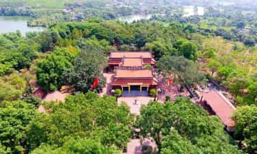
Tran Dynasty Relic Area in Dong Trieu
Tran Dynasty historical relic site in Dong Trieu belongs to An Sinh, Trang An, Binh Khe, Thuy An communes. Currently, this is the relic that retains the most imprints of the glorious Tran Dynasty. In the year At Dau, 1225, Ly Chieu Hoang ceded the throne to her husband Tran Canh, marking the transfer of power from the Ly dynasty to the Tran dynasty. From here, the Tran dynasty ruled the country for 175 years, with 12 kings, creating the most glorious dynasty in our country's history. The Tran Dynasty (1225 - 1400) with martial arts and literature, opened a heroic era in the history of building and defending the country. According to documents, the Dong Trieu area was the Tran family's first settlement. Afterwards, this land was given by King Tran Thai Tong to his brother Tran Lieu as a thang moc hamlet. When reigning, each dynasty paid attention to two issues: Duyen Trach was the land where the capital was located, and Am Trach was the place where temples and mausoleums were located. Besides Thang Long continuing to be chosen as the capital, the Tran Dynasty also built and developed two cultural centers and two mausoleum areas in the east and south of the capital. Many researchers have identified Dong Trieu as a major cultural and religious center, along with Thang Long - the political and economic center and Thien Truong Long Hung, the birthplace of the Tran Dynasty. The ancient name of Dong Trieu was An Sinh, but it was only during the reign of King Tran Du Tong that the name was changed, and it became the current Tran Dynasty historical relic site. This is a special national relic area including mausoleums, temples, pagodas, and towers with 14 relics spread out. This is a sacred holy land imbued with historical and cultural spirit and is the original hometown of the Tran Dynasty. Since the 13th century, the Tran Dynasty built Thai Mieu, worshiping the Three Patriarchs of Tran, which is the most important relic site. By the end of the 14th century, many tombs of King Tran were moved to Dong Trieu. The Tran Dynasty historical relics area includes 3 groups, the temple relics group, the mausoleum relics group and the pagoda relics group. Temples and mausoleums are attached to the Tran Dynasty's temples. Along with building mausoleums, the Tran Dynasty also built temples and shrines to worship the predecessors, and many pagodas also sprang up accordingly. But at that time, Dong Trieu only played the role of a mausoleum area and had not yet become the Buddhist center of Dai Viet. It was not until King Tran Nhan Tong became a monk that he went to Yen Tu mountain to practice and founded the Truc Lam Zen sect. He unified the previously existing Zen sects and the entire Buddhist church of the Tran dynasty under one umbrella. During this period, Dong Trieu became an important Buddhist center. The Tran kings built here a dense system of temples, tombs, pagodas and towers in a large landscape area stretching up to the slopes of Yen Tu mountain. Ngoa Van Ho Thien Pagoda is where the Buddha King Tran Nhan Tong preached sermons, and is also a place associated with the cause of propagating Buddhism in Dai Viet, training monks at a higher level. On Ho Thien Pagoda there is also a 7-storey stone tower whose architecture is still a mystery to researchers, attracting many researchers and history lovers from everywhere to visit and study. rescue. Quynh Lam Pagoda is considered the first Buddhist university in Vietnam, possessing a Buddha statue of one of the Four Great Elements of An Nam. The tower garden in the pagoda and the stone tower tombs of Zen masters have unique architecture, a typical cultural heritage not only of Quang Ninh province but of the whole of Vietnam. Over time, natural disasters destroyed, war ravaged, many ancient works in the Tran Dynasty historical site in Dong Trieu are only ruins. However, those ruins still retain their value in the hearts of the people. An Sinh in the past, Dong Trieu today is where the Tran Dynasty kings expressed the fallen leaves ideology of returning to the roots of the Vietnamese people. The things that still exist or even the things that are only left underground are still timeless heritages that not only carry the historical value of the famous dynasty but also demonstrate the 700 years of existence of pure Vietnamese Buddhism. Source: Quang Ninh Tourism Newspaper
Quang Ninh
8158 view
Rating : Special national monument

Yen Tu Historical and Scenic Area
Historically, Yen Tu has always been one of the Buddhist centers of the country, associated with many ancient architecture, built through different historical periods (Ly, Tran, Le, Nguyen). Geographically, Yen Tu is a low mountain range, belonging to the Dong Trieu arc system, a geological region formed in the Quaternary period, with bedrock types, such as sandstone, gravel and ancient alluvium... Geography The area's complex geology and geology have created magnificent landscapes, such as Ngu Doi waterfall, Vang waterfall, Silver waterfall, Heaven's Gate, Tung street, bamboo forest, Yen Tu mountain peak..., where there are unique architectural features. Traditional architecture seems to blend into majestic nature. Yen Tu area has a total natural area of about 2,686 hectares, including 1,736 hectares of natural forest, typical of the Northeast forest ecosystem, which also preserves many rare genetic resources of animals and plants... Interspersed with nature is a system of pagodas, temples, towers... Along the paths leading to the pagodas, temples, and towers, many pine trees are often planted. In this area, there are still more than 200 giant pine trees, belonging to 4 rare groups, planted about 700 years ago. In addition to ancient larch trees, the bamboo forest here is also famous since ancient times... Bamboo is a unique product of Yen Tu, symbolizing the vitality, purity and elegance of nature. Perhaps, that is also the reason why Tran Nhan Tong chose this place to practice and named "Bamboo forest", or Truc Lam, to name the Zen sect he founded. Yen Tu Festival is a spring pilgrimage festival, starting on January 10 every year and lasting for 3 spring months. The Yen Tu area includes several major Buddhist sites and architectures such as: 1. The ancient Bi Thuong Pagoda was built in the Later Le Dynasty, on a Nhat-shaped architectural foundation, and has been restored and embellished many times in history. Worshiping the Eighteen Arhats. 2. Suoi Tam Pagoda was built at the foot of the mountain, next to the bank of Bath stream. 3. Cam Thuc Pagoda Located on the left side of the road into Yen Tu. 4. Lan Pagoda and Giai Oan Pagoda were both built during the Tran dynasty. 5. The Hon Ngoc tower cluster is located on a fairly large, flat mound of land, including three stone towers and one brick tower. 6. Hue Quang Tower Garden now has only 64 towers and tombs, of which 40 towers were newly restored in 2002, 11 stone towers, 13 brick towers, some towers have collapsed, leaving only traces. 7. Hoa Yen Pagoda was built during the Ly Dynasty and was embellished many times throughout history. The pagoda is located halfway up the mountain, facing southwest. 8. Ancient Thien Dinh Am was originally a special ancient tower in Yen Tu, standing alone, behind Hoa Yen Pagoda. The tower is built of red bricks with green glaze, the surface is embossed with many strange patterns and animal faces. 9. One Roof Pagoda is nestled on the side of a high mountain. Half of the pagoda is hidden deep in a mountain cave, the other half is exposed to the outside and has only one roof. 10. Am Thung and Am Duoc are now only ruins. 11. Bao Sai Pagoda is located on the mountainside, facing southwest. 12. Van Tieu Pagoda is located on the mountainside. On both sides of the pagoda there are 2 high mountain ranges, forming a throne that surrounds the pagoda. To the right of the temple there is a stream. 13. Dong Pagoda is located on the highest peak of Yen Tu mountain, cast from bronze. The special historical and cultural values of the relic site have made Yen Tu a sacred place in the spiritual life of Vietnamese people. To affirm the special value of the monument, the Prime Minister decided to classify Yen Tu historical and scenic relics as a special national monument on September 27, 2012). Source: Department of Cultural Heritage
Quang Ninh
8336 view
Rating : Special national monument
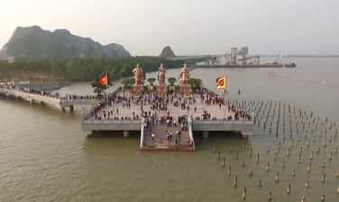
Bach Dang Historical Relic
Bach Dang Historical Relic is located in Quang Yen Town and Uong Bi City. This is the place marking the event when the Tran Dynasty's army and people achieved a famous victory - the Bach Dang Victory, defeating the Yuan Mongol invaders in 1288. In the history of our nation's defense of the country, Bach Dang River has witnessed our army and people three times resoundingly defeat the mighty Northern invaders, all with wooden stakes planted in the Bach Dang river bed. That was Ngo Quyen's Bach Dang victory in 938; 981 by Le Hoan and the peak was the Bach Dang victory in 1288 by Hung Dao Dai Vuong Tran Quoc Tuan. Bach Dang River has become a historical river, Bach Dang stake has become a symbol of the tradition of fighting foreign invaders by waterway of the Vietnamese people. After more than 700 years of sedimentation by the river, the pile pile was deep under layers of mud. It was not until 1953 that people digging soil to build dikes discovered the Bach Dang piles. At first, people did not have the knowledge and awareness to protect cultural heritage, so many piles were pulled up to make rafters and straw piles. After many excavations, archaeologists discovered hundreds of stakes, mainly ironwood, 2.6 to 2.8 m long and 20 to 30 cm in diameter, inserted straight. The average distance between piles is from 0.9 m to 1.5 m. Bach Dang stake yard relic area (including Yen Giang pile yard, Dong Van Muoi pile yard, Dong Ma Ngua pile yard). Yen Giang stake yard relic has an area of about 3,000m2 located at the mouth of Chanh River with a rectangular shape of about 120m long and about 20m wide. Yen Giang stake yard was ranked a special National Monument in 2012. After that, the monument was zoned for protection, an introductory stele was erected, and the access road was embellished to create favorable conditions for tourists to visit. This is also an address for students to learn about history and serve their studies. Currently, Yen Giang pile yard still has about 300 trees in the ground. At the relic site, the pile yard is filled with water to the pond for conservation. Near the Yen Giang stake yard is the Van Muoi copper stake yard with an area of about 6,000 square meters located at the mouth of the Rut River, in Nam Hoa ward, discovered by the people of Quang Yen during the process of farming and digging ponds. After the survey and excavation in 2005. Subsequent archaeological excavations found a total of nearly 200 stakes, showing that wooden stakes planted vertically and diagonally in the Van Muoi field area belonged to many types of wood used. both trunk and branches. The diameter of each pile is from 7 - 10 cm, the pointed part is only about 25 - 30 cm. However, the density of stakes here is very thick, usually 40 - 60 cm apart, some stakes are only 10 - 30 cm apart. According to researchers, this is the southern half of the Bach Dang stake field, while the northern half is the Yen Giang stake field. Because between the two piles there is a strip of high rocky dunes, when the tide is low, the boat cannot cross and is forced to go close to the shore. Therefore, Tran Hung Dao chose a position to place stakes on both sides of the dune to form a V-shaped defense line tightly covering the throat of the Bach Dang River to block the enemy's retreat, creating a glorious victory in the above battle. Bach Dang River in 1288. The pile was then buried under a layer of mud for better preservation. Also in Nam Hoa ward, Quang Yen town, the Ma Ngua copper pile yard with an area of about 2,100m2 was discovered and surveyed and excavated in 2010. This is the third pile yard in the Bach Dang pile yard. Located at the mouth of the Kenh River, about 1 km south of the Van Muoi copper pile. The pile yard is 70 m long and 30 m wide, with stakes of many types of wood with diameters from 6 - 22 cm densely arranged in strips like a wall. The three piles of Yen Giang, Dong Van Muoi and Dong Ma Ngua have created large, complex, hidden underground piles under the water, blocking the escape route to the sea, helping to destroy and capture 600 warships with 40,000 people. Yuan-Mongol generals during their third invasion of our country in 1288. Today, the Bach Dang stake yard relic area in Quang Yen town has been surrounded by a protective embankment. Some of the piles were retrieved and the remaining piles were preserved in an on-site display pit. However, most of the Bach Dang piles at this relic have rotted and broken tops, and the body of the pile is still stuck in the mud, but this is an extremely important evidence of the historical battle on the Bach River. Dang year 1288. With the special historical, cultural and scientific values of the relic site, on September 27, 2012, the Prime Minister signed a decision to classify the Bach Dang Victory historical relic site in 2012. 1288 is a special National Monument. Bach Dang Festival takes place from March 6-9 of the lunar calendar with many solemn rituals and rich festive activities, held at all points in the relic site. To honor the value of our nation's great victory day and commemorate those who sacrificed their lives in the Bach Dang battles. Source: Quang Ninh Electronic Newspaper
Quang Ninh
8631 view
Rating : Special national monument

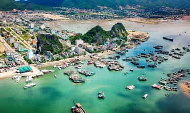
Ha Long Bay
According to scientists, the Ha Long area and the surrounding coastal and island areas of the bay include many terrigenous and carbonate sedimentary formations, ranging in age from the Paleozoic to the Neoproterozoic era. Many sedimentary formations in this area contain paleontological traces in various forms of fossils, including groups of animals and plants that have completely or almost completely disappeared from the earth. Geological history of Ha Long Bay, opened nearly 500 million years ago, with very different and quite complex paleogeographical circumstances. The presence of the bay and the islands in the bay are unique evidence of the earth's historical development, including geological characteristics and the continuous movement and development of the Karst terrain, the Fengcong system. and Fengling. The special terrain of Ha Long Bay is closely related to the climatic history and tectonic movement of the earth. The islands here are quite ideal models of Karst formed in tropical, humid conditions. The entire Ha Long Bay area is a Karst landscape over many millions of years, with pyramid-shaped, eroded Karst towers, creating an outstanding and unique beauty around the world. Stalactites in caves in the Bay Area are younger than other caves. Rainwater flows down through cracks in the cave ceiling and walls. Along the way, it dissolves and erodes limestone and deposits it into stalactites on the ceiling and stalagmites on the floor... Thousands of islands and dozens of beautiful caves have created the aesthetic value of the Bay. The beauty of Ha Long is created from 3 elements: rock, water and sky. The system of rocky islands in Ha Long has many shapes and forms, blending with the sky and sea, creating a watercolor painting. The inside of the large rocky islands is attractive with beautiful and strange caves. Dau Go Cave evokes an overwhelming feeling, with stalactites of various shapes and sizes. Thien Cung Cave is like a majestic and beautiful temple. Bo Nau Cave has an arched door, with countless stalactites hanging down as soft as willow branches. Sung Sot Cave is surprisingly beautiful, with stalactites in the shapes of wild chickens, toads, dragons, waterfalls, and many other shapes, opening up a fairy tale world. Caves such as Tam Cung, Trinh Nu, Ba Hang, Tien Long,... each cave has unique and amazing beauty. The tectonic history of Ha Long Bay has gone through very different paleogeographical circumstances, many times of mountain formation, sea retreat, subsidence, sea advance... Ha Long Bay still retains the imprints of the orogeny process. , the great trough of the earth, has the structure of ancient ramparts and trenches. Ha Long Bay area was once a deep sea in the Odovician - Silurian periods (about 500 - 410 million years ago), a shallow sea in the Carboniferous - Permian periods (about 340 - 250 million years ago), a coastal sea in the late Paleogene period, early Neogene period (about 26 - 20 million years ago) and experienced several sea encroachments during the Anthropocene period (about 2 million years ago). In the Triassic period (240 - 195 million years ago), when the earth in general and Europe in particular had a hot and dry climate, the Ha Long Bay area was wet swamps, with forests of cycads and giant ferns. accumulation of many generations... The Karst topography of Ha Long Bay has global significance and is fundamental to geomorphological science. The geological environment is also the foundation for other values of the bay, such as biodiversity, archaeological culture and other human values. The total number of plant species living on the islands in Ha Long Bay is about over a thousand species. A number of different plant species communities have been found, such as mangrove species, island sandbank plants, species growing on mountain slopes and cliffs, on mountain tops or growing at the mouths of caves or caves. rocks. Researchers from the World Union for Conservation of Nature (IUCN) have discovered 7 endemic plant species of Ha Long Bay. These species are only adapted to living on the limestone islands of Ha Long Bay, and cannot be found anywhere else in the world, such as: Ha Long cycad, purple astragalus, Ha Long palm, antler astragalus, anthurium. Ha Long ear, Ha Long's five family envelopes, golden flower guard girl. According to statistics, the closed evergreen, tropical humid forest ecosystem in Ha Long and Bai Tu Long has: 477 species of magnolia, 12 species of ferns and 20 species of mangrove plants; As for animals, there are also 4 species of amphibians, 10 species of reptiles, 40 species of birds and 14 species of mammals. The results of research, archeology and culture show that the presence of prehistoric inhabitants in Ha Long Bay area quite early, has created successive ancient cultural forms, including including Soi Nhu culture (about 18,000 - 7,000 years BC), Cai Beo culture (7,000 - 5,000 years BC) and Ha Long culture (about 3,500 - 5,000 years ago). The main way of life of Soi Nhu's owner is "catching shellfish, including gathering fruits, digging tubers and roots", knowing how to catch fish but not having a fishing career. The Cai Beo site is one of the first pieces of evidence to confirm that the ancestors of the ancient Vietnamese people, from a very early age, confronted the sea and developed here a brilliant culture, a meeting point. convergence of many different elements and nuances into a very old traditional cultural line in Vietnam and Southeast Asia: the Cuoi cultural line. Regarding the way of residence and living of Cai Beo people, in addition to hunting and gathering, there is also exploitation of the sea. Ha Long Bay is an area with outstanding global values, most notably aesthetic, scientific, historical, archaeological values... In 1962, the Ha Long Bay area was recognized as a monument. national landscape. In 1994, Ha Long Bay was recognized by UNESCO as a world natural heritage for its aesthetic value and was re-recognized for the second time, with exceptional global value in geology and geomorphology in 2000. With the special historical, cultural, scientific and aesthetic values of the bay, the Prime Minister decided to classify Ha Long Bay Scenic Landscape as a special national monument (Decision No. 1272/QD -TTg, August 12, 2009). Source: Department of Cultural Heritage
Quang Ninh
6437 view
Rating : Special national monument

Man Mountain
The historical and scenic relic complex of Man Mountain is located in Da Trang village, Thong Nhat commune, Ha Long city, with an area of 150 hectares (including the entire Man Mountain, Bach Thach temple; shrines: Thanh Mau, Ong Lang, Ong Dai, Ong Coc; Xich Tho communal house; and Mac Dynasty relics). Man Mountain's name in ancient bibliographies is "Ban Son" meaning beautiful mountain, perfect from the inside out. Because the mountain has the Man River flowing through it, local people often call Ban Mountain Man Mountain (from "Man Mountain"). ” is a misreading of the word “Man”). According to the records of Dong Khanh Du Dia Chi (National History Office of the Nguyen Dynasty compiled in 1886-1888), Hoanh Bo at that time had many beautiful rocky mountains like Ban Mountain (Man Mountain). ), Truyen Dang Mountain, Hap Mountain, Phuong Cac Mountain... However, there are only two famous mountains that are ranked as scenic spots during the Dong Khanh period: Man Mountain and Truyen Dang Mountain (today's Bai Tho Mountain). Man Mountain is located between two branches of Da Trang stream (Bach Thach Khe) and Luong Ky stream (Khe Ban) flowing into Da Trang river. Located at an altitude of nearly 300m above sea level, the shape of the mountain reminds us of an elephant in a kneeling position, its trunk pointing down to Khe Ban. The system of natural, large, but relatively uniform rocks surrounds Man mountain like the brim of a hat. Dotted among the green and white of the rocks are the green of the leaves, the red and yellow of the flowers and the lush four-season flora around. Halfway up the mountain with steep and dangerous cliffs, there are also caves with smooth, colorful stone fibers and stalactites, creating a magical and mysterious beauty. Looking down from the top of Man Mountain, the East and West sides of the mountain are surrounded by the Ban River and Da Trang River, the water is as clear as a jade eye, creating an enchanting landscape painting. Not only is it a beautiful scenic spot, with charming scenery with the famous proverb that has been passed down to this day, "The mountains and seas, ten thousand great kings", the famous mountain from the Dong Khanh period also contains valuable values. about history and culture. According to local people, since ancient times, people in the area often considered Man Mountain and Bai Tho Mountain to be two pairs of twin mountains with many fascinating and thrilling legends. Among them, Man Mountain is associated with the legend "The giant carrying stones and patching the sky". Legend has it that every step he took was associated with some place names that have been passed down to this day. In particular, when he turned his shoulders, the pair of shoulders broke in half, one side fell into Ha Long City, Bai Tho Mountain, and the other side fell into Xich Tho territory (formerly Hoanh Bo district), which is Man Mountain today. Man Mountain relics are also associated with historical stories about Cao Son Dai Vuong, Quy Minh Dai Vuong and legends related to the system of communal houses and temples scattered across Thong Nhat commune and Hoanh Bo ward such as: Ong Coc temple, Ong Lang temple, Ong Dai temple, Xich Tho communal house... To worship the mountain god Man (Cao Son, Quy Minh Dai Vuong) and the mountain god Long Hai (the god who governs the river region), people in the area built Bach Trach temple right at the foot of the mountain. Having gone through many historical events, up to now the temple no longer worships Cao Son, Quy Minh Dai Vuong and Long Hai mountain god, but has built an additional temple to worship Buddha and worship Mother Thuong Ngan and Tam Thanh Mau. The temple has a campus of nearly 1,000 square meters, including the following buildings: White Stone Lady Palace, Buddha Worshiping Temple, Son Than Worshiping Place, and the Palace of the Native Lady. Most of the buildings are built with bricks, plastered with tiled roofs and tiled floors. Besides the landscape and spiritual values, the Man Mountain relic complex also has great historical value. According to research by historians, Man Mountain was also the headquarters of the Ly Dynasty army during the resistance against the Song Dynasty in the 11th century. During the two resistance wars against the Yuan-Mongol invaders (1285, 1288), Man Mountain was chosen by Hung Dao King Tran Quoc Tuan as the strategic reserve headquarters of the Tran Dynasty's navy. After winning the Battle of Bach Dang in 1288, King Tran Thanh Tong commanded the Tran army to cross the sea into Cua Luc Bay, stationed at Man Mountain and from there advanced to intercept and pursue the Nguyen army led by Thoat Hoan. On the way back to the country via Dinh Lap - Lang Son road... With the charming beauty that the Creator has bestowed upon it, along with the system of temples and shrines associated with many historical legends, the historical and scenic relic complex of Man Mountain has been decided by the Ministry of Culture, Information and Tourism. Ranked national monument on July 8, 2014. Source: Ha Long Quang Ninh tourism newspaper
Quang Ninh
4497 view
Rating : National monument
Archaeological relic of Hon Hai Co Tien
Historical and archaeological relic Hon Hai Co Tien belongs to group 65, Bach Dang ward, Ha Long city. From 2001 to present, Quang Ninh Museum has cooperated with the Vietnam Institute of Archeology and the Vietnam Museum of History to survey, excavate and discover many relics bearing typical marks of the late period of Vietnamese culture. Ha Long culture (Late Neolithic period) to the Dong Son Culture period (Metal Age) dating from 4,000 to 2,000 years ago. Here, scientists have unearthed 91 artifacts, 1,000 scientific specimens including production tools, daily utensils, jewelry, beliefs... with ceramic, bone, and stone materials; a burial site with 46 ancient human remains, some of which are relatively complete. The remains were buried bundled with burial items. Quang Ninh Museum also surveyed 4 locations in the valley and foothills, and collected 294 artifacts and over 20,000 scientific specimens including bronze, stone, bone, and ceramic materials such as fish hooks, axes, chisels, jewelry. Here, scientists discovered many pieces of bronze molds of the Dong Son Culture along with pieces of bronze slag used to cast axes, spears, spears... In Area I, Quang Ninh Museum also discovered a population of fossil corals that may belong to the Devonian - Carboniferous period (about 400 million years ago today). Along with archaeological value, Hon Hai Co Tien Relic also has primeval rocky forest with many precious primates and reptiles such as golden-haired monkeys, salamanders, geckos... and a rich flora system. Natural resources of rocky mountain forests such as tea tree, Phat Du mountain, Ha Long orchid, Golden flower Venus, Ha Long Thien Tue... The recognition of the Hon Hai Co Tien relic as a National Monument has contributed to enhancing the cultural value of the World Heritage Site of Ha Long Bay and the important historical position of Quang Ninh with the ancient culture of Ha Long, in Northeast region of Vietnam. At the same time, the monument also creates a unique cultural tourism product right in Ha Long city. Source: Department of Culture and Sports of Quang Ninh province
Quang Ninh
8321 view
Rating : National monument

Yen Lap lake scenic relic - Loi Am pagoda
The complex of Loi Am Pagoda - Yen Lap Lake relics has long been known by many tourists from all over as a charming landscape of Ha Long. With values of culture, history, science, art and landscapes, bearing the mark of the ages, on November 23, 1997, Loi Am Pagoda - Yen Lap Lake was recognized by the Ministry of Culture and Information. Ranked as a National Monument. As for many people of Ha Long City, this place has become an indispensable pilgrimage site every Spring vacation. This cluster of relics is located on the right side of Highway 18A (direction from Ha Long City to Hanoi) in Dai Yen ward, Ha Long city. Through research of historical documents, Loi Am pagoda was built in the year of Quang Thuan during the reign of Le Thanh Tong and the inauguration date may coincide with the time when King Le went to patrol An Bang and engraved a poem on Bai Tho mountain (1468). . Yen Lap Lake is the largest irrigation project in Quang Ninh province. After more than 30 years of exploitation and use, Yen Lap Lake is still effective, not only contributing to reducing droughts and floods but also also plays an important role in providing water sources to serve the socio-economic development of Ha Long city, Uong Bi city and Quang Yen town. Viewed from above, Yen Lap Lake appears with a gentle blue color, surrounding the lake are undulating mountains, and small islands emerge in the middle of the lake, creating a natural, captivating look. The cluster of historical and scenic relics of Loi Am Pagoda - Yen Lap Lake has created a poetic landscape, which has been famous since ancient times, and is now even more famous to attract visitors from all over the country. Loi Am Pagoda is located in a semicircular area, extending from the top to the middle of the mountain. In front is the lake, following the "leaning on the mountain, facing the water" position that our ancestors once compared to "the dragon flanking the tiger, the left side shielding, the right side supporting, there are sacred mountains converging, there are mystical universes overlapping". . Loi Am Pagoda is at an altitude of 395m above sea level, built in the Southeast direction, which is the direction of wisdom and spirituality. The remaining traces left today are that Loi Am Pagoda was built according to the architectural structure of "foreign internal affairs", a typical example of Le Dynasty architecture. From the foot of Loi Am mountain up to the temple gate along Chua Ngu street, with a length of about 850m and an average width of 2.5m. On both sides of the pagoda there is a stream of injustice that splits into 2 branches. When passing through the pagoda, it merges into a stream. The stream has water flowing all year round, originating from the top of the mountain and pouring into Yen Lap Lake. Rows of ancient trees planted in front and around the pagoda are a symbol of elegance and longevity. In addition, the pagoda is also rich with rows of banyans, brasses or brooches, creating a sacred place for meditation but also very close to mundane life. Vietnamese feudal kings often came here to visit and praise. At the end of the 19th century and the beginning of the 20th century, when the French colonialists invaded our country, all pagodas, temples, and shrines were seriously destroyed. As for the right-hand front street, there is still a wall 1.5m high, 30cm thick, built entirely of red bricks. The rear of the three treasures area still retains a wall 1.2m high and 20cm thick. Next to the pagoda on the right is a tower garden made of fine-grained green stone, with a solid tenon grafting technique. The three-storey tower remains intact, with the words "Pho Minh tower" clearly written on top. The top of the tower is carved with a pedestal holding a Cam Lo water vase, gradually shrinking towards the top, radiating forever in the air, giving visitors the feeling of being transcended at the door of meditation. In front of the temple door, there is also a stone incense tree built in the shape of four pillars. On the incense roof, where the tips of the blades show a twisted pattern, to some extent, it symbolizes the wish for "favorable rain and wind". Also located in front of the pagoda on the left is a row of ancient stone stele consisting of 5 intact pieces. During each festival season, people and tourists cross Yen Lap lake to Loi Am pagoda. To feel the beauty here is to surf on a boat to enjoy the poetry and fresh air. The surface of Yen Lap Lake has no rushing waves of the sea, no natural caves like Ha Long Bay... But coming to Yen Lap Lake is to find the serenity of a gentle landscape, water surface. Ripples in the gentle breeze can be seen all the way to the bottom, floating islands on the lake are interesting resting spots. The cluster of historical relics and scenic spots of Loi Am Pagoda - Yen Lap Lake has imbued with the imprints of the ages with many values in history, science, art and landscapes. Through research and survey of the relics of Loi Am Pagoda, we can confirm: Loi Am Pagoda is a priceless cultural art treasure. In addition to scientific, artistic and cultural values, Loi Am Pagoda also contains historical values of the nation's struggle. Located in a hidden mountain and forest terrain, in 1946 the 98th Regiment was stationed here, led by comrade Vu Manh Hung as Platoon Leader, using the pagoda as an observatory, the unit fought against the French colonialists, establishing Achieved many victories and crushed all enemy sabotage plots. Now, Loi Am Pagoda is a harmonious landscape in the "charming landscape of mountains and water". Source: Ha Long City Electronic Information Portal
Quang Ninh
4423 view
Rating : National monument
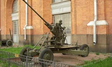
37mm artillery battle of Hon Gai Coal Engineering Enterprise
The 37 mm anti-aircraft artillery field of Hon Gai Coal Processing Enterprise is a historical relic that was ranked at the national level in 1997. Here, during the period of fighting against the destructive war of the American invaders, the self-defense soldiers of the Hon Gai Wharf Enterprise (now Hon Gai Coal Processing Company) achieved outstanding feats, shooting down American planes. . The relic of the 37mm artillery battle of Hon Gai Coal Processing Enterprise is located on a hill 102m above sea level. From here, you can cover many locations of Hon Gai Town (now Ha Long City) such as the ferry terminal, Hon Gai port and surrounding residential areas. In 1960, the self-defense unit of Ben Hon Gai was established. The unit's first battle was on August 5, 1964, when American planes rushed to bombard our Naval Port in Bai Chay, the self-defense soldiers of Ben Hon Gai fought heroically, along with other soldiers. The air defense, navy and self-defense forces of other units created a fire net, shot down 3 planes, and captured American pilot Everd Alvaret when he parachuted into Ha Long Bay. . After this battle, 28 comrades of the unit were awarded Badges 5-8, typically Dang Ba Hat, Tran Minh Thanh... In 1966, Ben Hon Gai Enterprise formed 2 combat groups consisting of 30 people, the commander was comrade Le Quang Minh, the deputy commander was comrade Dang Ba Hat. On March 10, 1967, American enemy planes rushed in from many directions to attack Ba Deo area, Nha Tho street, Hill 102... With the brave fighting spirit of self-defense soldiers, an F8 plane of The American enemy was shot and caught fire, rushing out to sea. At the end of 1968, after being equipped by the province with four 37 mm anti-aircraft guns, Ben Hon Gai Enterprise established a company of 45 people led by comrade Dang Ba Hat as Company Commander. The battlefield was located on Hill 102 (Ferry Hill). On May 18, 1972, the Company participated in combat and shot down an F4 of the American enemy. The victory increased the excitement and determination to win for the entire Company, from commanders to soldiers. The American enemy's escalating war is becoming more and more fierce. On July 12, 1972, they focused on attacking Hon Gai town again. At this time, two ferries filled with people and cars were on the journey across Cua Luc River. The situation was very critical. Comrade Dang Ba Hat both commanded the reinforcements and protected the ferry while directly fighting. The battlefield was hit by American planes with piercing bombs. Comrade Dang Ba Hat was injured in the stomach and heroically died while still holding the command flag. After the battle, the Company suffered great losses but continued to hold on and deploy to attack the enemy. In October 1972 alone, the Company fought 37 battles, defused many bombs, piercing bombs and cluster bombs of all kinds... With the victories achieved, in early 1973, the 37mm Self-Defense Company of the Hon Gai Wharf Enterprise was honored to be awarded a flower basket by President Ton Duc Thang right at the battlefield and also in this year, the Enterprise Hon Gai Wharf was honored by the Party and State with the title of Hero of the People's Armed Forces. Martyr Dang Ba Hat, with his example of fighting and selfless sacrifice, was posthumously awarded the title of Hero of the People's Armed Forces in 1995. In order to preserve, restore and promote the value of the relics of the 37 mm anti-aircraft artillery battle of the Hon Gai Wharf Enterprise, it is known that the Provincial People's Committee and the Vietnam Coal and Mineral Industry Group have reached an agreement on the project. Investing and embellishing monuments. Currently, the basic procedures have been completed, just waiting for the road to Bai Chay bridge to be completed to start construction. Projects expected to be renovated include building a monument to Dang Ba Hat, restoring trenches, ammunition magazines, shelters, building an exhibit house, etc. After being renovated, the monument will not only be a A place to mark victories and traditional education, but also contribute to increasing the value, meaning and beauty of Bai Chay bridge in particular and Cua Luc land in general. Source: Quang Ninh Electronic Newspaper
Quang Ninh
4156 view
Rating : National monument

Bai Tho Mountain
Bai Tho Mountain is located in the center of Ha Long city. Three sides of the mountain are densely populated areas, the west and south of the mountain are next to beautiful Ha Long Bay. Bai Tho Mountain is a place that records historical marks, a symbol of Ha Long city, where many famous relics gather such as: Long Tien Pagoda, Duc Ong Temple, Quang Ninh Post Office Main Electric Center; Battlefield 12 mm 7; Hong Gai squad cave; Air defense caves evacuated (from cave No. 1 to cave No. 6). As a gathering place of relics of many types such as historical and scenic, Bai Tho Mountain has many historical, cultural and aesthetic values (recognized by the Ministry of Culture and Information as a Historical relics and landscapes dated August 31, 1992 (Addition of Ha Long Bay scenic relics area) have become an interesting destination for historians, poets, photographers, people and visitors. travel near and far. From the top of Bai Tho mountain, we can see the entire panorama of Ha Long Bay. Bai Tho Mountain is like a living monument recording important historical marks of many eras. Hundreds of years ago, when it was still called Roi Lamp Mountain (literally called Truyen Dang Son). According to local folk legend, Truyen Dang Mountain is the highest mountain in the Cua Luc sea area, standing on the ancient maritime route from the North to the interior of our country. Feudal dynasties used Truyen Dang mountain as a typical guard post in the Northeast sea region. Every night, the garrison hung a lantern on the top of the mountain to signal that the situation in the Northeast was still quiet. But when there was an enemy, the soldiers would burn wood so that the smoke rising high would alert the mainland. From the hanging of fire lamps by the soldiers stationed on the top of the mountain, the mountain is called Doi Lamp, the literal name is Truyen Dang. In 1468, King Le Thanh Tong led his army to patrol the An Bang sea and stationed his army under Truyen Dang mountain. Moved by the magical beauty of the clouds and sky of Ha Long water, the king wrote a poem and had it engraved on the south side of the cliff and from then on the mountain was named Bai Tho. Two hundred and sixty-one years later (1729), Lord Trinh Cuong wrote a poem depicting King Le Thanh Tong's poem and had it engraved nearby... During the resistance war against the US (1968), Bai Tho Mountain was also an air defense sentry guarding the sea and sky in the mine area, an ambulance cave, serving combat and the place where the telegraph center of the Quang Ninh Provincial Post Office was located. …. In particular, the event of planting the first Party flag on Bai Tho Mountain carries great historical significance and value. On the morning of May 1, 1930, the Party flag fluttered on Bai Tho Mountain, marking an important milestone in the revolutionary process in the mine. It urged workers and laborers in the mine to step up to the battlefield to fight and fight. overthrew the brutal rule of colonialism and now that flag still flutters on Bai Tho mountain, the symbol of Ha Long city - the heroic mining land. Also during the resistance war against the Americans, Bai Tho Mountain also contributed to creating an important historical event. History also records: The militia and self-defense force of Bach Dang ward, right in the center of Hon Gai city (now Ha Long city), at the foot of Bai Tho mountain, established a 12mm 7 battery and put it on duty immediately. on Bai Tho mountain. This battery is an air defense position that stands and fights in extremely arduous conditions and actively contributes to the overall victory of the army and people in the Quang Ninh mining area. With another role, in the years 1964 - 1975, in the caves on the eastern slope of Bai Tho mountain, the main electrical center of Quang Ninh Post Office was chosen as a place to evacuate service buildings and place a microwave station to transmit The waves transmit important information, thereby not only ensuring smooth communication but also contributing to fighting back against American aircraft and protecting the safety of the broadcasting station. Bai Tho Mountain is where many important historical events of Quang Ninh province took place from the Feudal period to the anti-French and anti-American periods, if invested in embellishment, combined with relics such as the 37ly Battlefield of Vietnam. Hon Gai Coal Enterprise (Ha Long City), Dong Trieu War Zone Center (Bac Ma Pagoda) (Dong Trieu District); Son Duong revolutionary base area, Bang Ca anti-French resistance base area (Hoanh Bo district) and revolutionary historical relics of Van Don, Tien Yen, Ba Che districts, Mong Cai city will become a tour. Travel to visit the fascinating ancient battlefields of Quang Ninh province. Source: Quang Ninh cultural and sports electronic information portal
Quang Ninh
4342 view
Rating : National monument