Relic point Vietnam
Việt Nam
Historical relic of the Ba To uprising
The Ba To uprising broke out on March 11, 1945 with 278 guerrilla members, two days after Japan overthrew the French in Vietnam, establishing a new government in Ba To district and Quang Ngai province. The Ba To uprising was associated with the Ba To Guerrilla Team, the first armed organization of the people of Quang Ngai province directly organized, trained and led by the Communist Party of Vietnam. The Ba To guerrilla team is one of the revolutionary armed forces born in the pre-uprising period and became the core force of the revolutionary masses in Quang Ngai during the days of the general uprising in August 1945, contributing part in building revolutionary armed forces in Thua Thien - Hue and the South Central region. Many members of the Ba To Guerrilla Team later became talented officers and excellent generals of our army in the two resistance wars against the French and the Americans. In 1980, the complex of relic sites about the Ba To uprising and the Ba To guerrilla group was recognized as a national historical and cultural relic by the Ministry of Culture and Information. In 2010, the Ba To Guerrilla Team was awarded the title of Hero of the People's Armed Forces during the anti-French period by the State. Accordingly, the special national relic site of the Ba To uprising includes 11 locations:. 1. Lieng river section (Ba To town), behind Ba To station, where revolutionary soldiers pretended to have tuberculosis, demanded to live in isolation under boats, covered the enemy's eyes to print leaflets and propaganda materials Revolution. 2. Nuoc Nang brick kiln (Ba To town), where the Quang Ngai Provincial Party Committee was established at the end of December 1944. 3. Comrade Tran Quy Hai's house (Ba To town), where the Provisional Provincial Party Committee held an extraordinary meeting (March 10, 1945) to decide to rebel and seize power. 4. Suoi Loa watchtower (Ba Dong commune), where the Quang Ngai Provincial Party Committee held an emergency meeting at noon on March 11, 1945 to decide on the direction of the uprising to seize power in Ba To district capital. 5. Ba To station, the garrison of the army commanded by the French station chief, controlling Ba To district, was captured by insurgents on the night of March 11, 1945. 6. The Procuracy Department (Ba To town) is where on the night of March 11, 1945, rebel forces rounded up Procurator Bui Danh Ngu, confiscating all seals, records, documents, and weapons; take power back to the people. 7. Ba To Stadium (Ba To town), where the Ba To guerrilla team was founded and where on the morning of March 12, 1945, the Uprising's Steering Committee organized a large rally, declaring He abolished the feudal colonial government and established a revolutionary government. 8. Hang En beach (Ba Vinh commune), at the foot of Cao Muon mountain, is where on the night of March 14, 1945, the Ba To guerrilla team held the oath "Sacrifice for the Fatherland!". 9. Ben Buon (Ba Thanh commune), this is the place to receive food and weapons donated by lowland people, transported by river to supply Ba To guerrillas to build an anti-Japanese war zone in Fig Juice, Leaf Juice. 10. Nuoc La War Zone - Voot Rep Cave (Ba Vinh commune), where the Ba To guerrilla group stationed troops, built a base, and practiced military resistance against the Japanese. 11. Cao Muon Mountain War Zone (Ba Vinh commune), one of the places where the Ba To guerrilla team based itself in the early days of the uprising, building forces and cultivating Kinh-Thuong solidarity. In August 2013, the Prime Minister decided to recognize the communes: Ba Vinh, Ba Giang, Ba Dong, Ba Chua, Ba Thanh and Ba To town as belonging to the "Central Safety Zone in Quang Ngai" during the anti-French period. On December 25, 2017, the Prime Minister decided to recognize the locations of the Ba To uprising as "Special National Monuments". Source: Collection of national monuments
Quang Ngai
8754 view
Rating : Special national monument
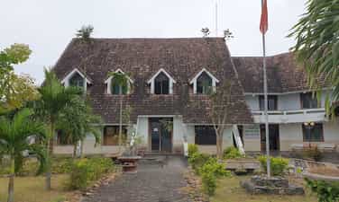
Dang Thuy Tram Hospital
Martyr - Doctor Dang Thuy Tram was born on November 26, 1942, a son of his hometown Thua Thien Hue, born and raised in Hanoi. Father is surgeon Dang Ngoc Khue, mother is Pharmacist Doan Ngoc Tram - former lecturer at University of Pharmacy, Hanoi. In 1966, after graduating from Hanoi Medical University. Dang Thuy Tram brought with him the strength of youth, the will to fight, and the ambitions of youth, volunteering to accept the duty of a physician in the Southern battlefield. Her working place is Duc Pho district hospital, Quang Ngai province. While on duty in the area, she was ambushed by the enemy and heroically died in 1970 at a very young age, just under 28 years old with 3 years of professional experience and 2 years of Party life. Local people buried her right on the land where she sacrificed and her family reburied her at the Martyrs cemetery in Xuan Phuong commune, Tu Liem district, Hanoi capital. Dang Thuy Tram relic area includes: Dang Thuy Tram Clinic in Pho Cuong commune, Duc Pho district and historical relics associated with Dr. Dang Thuy Tram's activities during the war such as: Forward surgical station in Bong Dau mountain, Quy Thien village, Pho Khanh commune. Secret bunker in the garden of physician Ta Thi Ninh in Nga Man village, Pho Cuong commune. Duc Pho clinic at Go Chay hill, Dong Ram 1 village, Ba Kham commune. Duc Pho Clinic in Nuoc Dang village, Ba Trang commune, Ba To district. Dang Thuy Tram Clinic is located right next to National Highway 1A, about 50km south of Quang Ngai city. The clinic was built according to the wishes of Dr. Dang Thuy Tram during his lifetime. This is the first medical examination and treatment model with a special model in the nationwide community health care and examination system. In addition to performing medical examination and treatment for people in the area, the clinic is also an address that attracts tens of thousands of visitors each year. Dang Thuy Tram Clinic was built on an area of 3,900m², with architecture following the style of Rong house - Central Highlands so that visitors can feel the closeness and friendliness. Palm rows along the walkway and front porch make the clinic look like a resort with a garden. Prominent on the main campus is the monument of Hero and Martyr - Doctor Dang Thuy Tram, holding a hat to cover his head, striding forward, as if rushing through the forest while on duty, looking for a new location. It was safer to build an infirmary to treat wounded soldiers and avoid enemy raids. In addition to the treatment area, the clinic also has a separate display area introducing artifacts and images related to Heroes and Martyrs - Doctor Dang Thuy Tram in particular and the revolutionary struggle tradition of the Duc Pho people. (Quang Ngai) and Zone 5 in general. In particular, in the exhibition hall are the luggage left behind by Doctor Dang Thuy Tram before his death, which are two diaries that were picked up on the battlefield by an American veteran named Frederic Whitehurst, a former US military intelligence officer. and kept for 35 years until it was returned to the author's family at the end of April 2005. Due to difficulties in finding Doctor Dang Thuy Tram's family and seemingly despair, 2 diaries This document was donated by Frederic Whitehurst to the Vietnam Archives Institute at the University of Texas, Lubbock for storage and preservation. These two diaries were later published by the Writers' Association Publishing House as a book titled "Dang Thuy Tram's Diary". The works were successively translated into many languages and published in many countries, making the image of Dr. Dang Thuy Tram familiar to international friends, becoming a shining symbol of the spirit of fighting against injustice. hidden and the desire for peace of the young generation of Vietnam. It can be said that with the far-reaching influence of Dang Thuy Tram's diary, it is one of the bright examples for spiritual education and revolutionary heroism in modern times... That is why today the Dang Thuy Relic Area Tram is a very famous attraction for young people every time they have the opportunity to visit Quang Ngai. Source: National Museum of History
Quang Ngai
7042 view
Rating : National monument
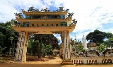
Thien An Pagoda
Thien An Pagoda is located on top of Thien An mountain in Tinh An commune, Son Tinh district, 3 km from Quang Ngai city center. The ancient pagoda has the most beautiful and unique architecture in Quang Ngai. Thien An Pagoda was opened and formed in 1716, but at that time, this was just a small, quiet hermitage, few people frequented it. After that, the temple was restored and the number of monks, nuns and Buddhists coming here increased more and more. In 1717, this place was given a plaque by Lord Nguyen Phuc Chu with the words, "Sac Tu Thien An Tu". Over the months of experiencing wind and rain at the pagoda, the sign was seriously damaged and was recreated by Zen master Hoang Phuc in 1946. And it was not until 1964 that this place was officially restored and built. became a temple at the end of 1965. Since its inception, Thien An Pagoda has undergone 5 times of restoration, construction and expansion. To date, the temple's campus has increased to about 1 hectare. Over more than 300 years of establishment and existence, Thien An Pagoda has had about 15 abbots, of which 6 are revered as monks - sixth ancestors. With the pagoda's rich history, Thien An Pagoda was included in the list of national historical relics of the Ministry of Culture and Sports in 1990. Thien An Pagoda has a very large space with surrounding walls. Thien An Pagoda impresses with its elaborate motifs of dragons flanking the moon, along with scrolls and a system of parallel sentences. Above the three-entrance gate is a statue of the guardian god. Inside are two rows of Arhat statues on both sides of the Buddha statues. In the grounds of Thien An Pagoda, there is a large area of land with ancient trees providing shade all year round. Thien An Pagoda was built in the Ruong architectural style, made entirely of wood, with the main pagoda in front and the ancestral house at the back of the temple grounds. In particular, in the temple there is a precious bell with a wide echo throughout the region. The area around Thien An Pagoda is a flower garden. Among them, the statue of Avalokiteshvara Buddha in the surrounding temple grounds is planted with flowers and many beautiful ornamental plants. To the east of the pagoda is the tomb area, this is the burial place of the abbots. To the south is Huynh Thuc Khang's tomb. In the north is a large lotus lake blooming with fragrant flowers. The water in the lake is blue and the most impressive is the rockery in the middle of the lake. Next is the monk's tomb with a lotus statue and a stupa. Thien An Pagoda is famous for having a Buddha well in the temple grounds, the well water is deep and cool all year round. The special thing about Buddha's well is that the water source in the well has never dried up and people here believe that drinking water from the well can cure all kinds of diseases. Thien An Pagoda - a pagoda with more than 300 years of history associated with many sacred and mysterious anecdotes. The temple is a place to send prayers, hoping for good things to come in the coming days. Source: People's Committee of Quang Ngai province
Quang Ngai
5563 view
Rating : National monument

Chau Sa ancient citadel
Chau Sa Citadel or Hoi Citadel, located in the downstream area, left bank of Tra Khuc River, in Son Tinh district, Quang Ngai province. The south borders Tra Khuc river, the north borders Ham Giang river, the east borders Dinh field and the west borders Ban Co mountain. Chau Sa ancient citadel was built by the Champa people in the 9th century to protect the south of the capital Tra Kieu. According to the information recorded on the stele, Chau Sa Ancient Citadel was built in 903. After the king of the 5th dynasty of the Champa kingdom, Java Vikrantavarman III, passed away, Sri Indravarman II became the successor. The new king moved the capital from Panduranga (now Ninh Thuan) to Amaravati (now Quang Ngai) and established the Indrapura dynasty (Cham Thanh). Then, in the south of Indrapura, the Cham people built Chau Sa citadel, an important defensive structure of the Champa empire, with the goal of preventing and preventing uprisings and invasions from other states. . Chau Sa Citadel was once the capital, economic, cultural and political center of the prosperous Champa kingdom. This was a place of bustling trade between the Champa kingdom and neighboring countries during the late 9th and early 10th centuries. After the Champa kingdom weakened, Chau Sa Ancient Citadel continued to experience many upheavals in Vietnam's history. In 1471, after King Le Thanh Tong expanded his territory to the South, Chau Sa citadel became an important military post until Quang Ngai citadel was built in 1807. Before 1975, Chau Sa citadel was officially established. Saigon government used it as a military post and named it Son Thanh post. Chau Sa ancient citadel is an architectural wonder built of earth on a large scale, including two layers of citadel: inner citadel and outer citadel. Each of these citadels has unique architectural features and plays an important role in the historical development of the Cham people and the Champa kingdom. 1. Inner citadel. The inner citadel has a total of five doors, each door is located in the East, West, South, North and Southwest directions. These gates are built of brick and have raised gazebos. In particular, the southern gate was carefully dug and reinforced and is considered the main gate of the citadel. With its special terrain and strategic location, it has created a solid defense system for Chau Sa Ancient Citadel. Chau Sa citadel also has two citadels called "crab claws", connecting the inner citadel with the largest river of Quang Ngai province, Tra Khuc river. 2. Outer city. The outer citadel was skillfully built by combining excavation and taking advantage of the natural terrain of the area. The outer citadel uses low hills, rivers, canals, and ponds in the area to create a fortified system, protecting Chau Sa Ancient Citadel from outside threats. The outer citadel was only built with three ramparts in the West, East and North directions. The western and eastern walls of the citadel were built firmly and solidly, while the northern side mainly relied on the mountains. The south side has no protective wall, overlooking the Tra Khuc River. Many ancient ceramic artifacts and Go Pho ancient tower were also found here, showing that the citadel was once a pilgrimage destination for Brahmin believers in ancient times. On the outskirts of Chau Sa, many artifacts called "quails" were also found, shaped like playing cards worn on the body. Inside the citadel there are also many beautiful Buddhist miniatures made from terracotta. In 1994, Chau Sa ancient citadel was recognized as a national relic. Source: Collection of Quang Ngai tourism newspaper
Quang Ngai
5421 view
Rating : National monument

An Dinh village communal house
An Dinh village communal house (An Dinh village, Hanh Dung commune, Nghia Hanh district) was built in 1820, with contributions from seven ancient families: Tran, Nguyen, Pham, Huynh, Vo, Phan, Le and villagers. to create. An Dinh village communal house not only has a rich history and is imbued with the nation's cultural identity, but is also a unique work of art. Over time and the changes of history, An Dinh village communal house has become a traditional cultural symbol of Vietnamese villages. The communal house is located on the highest and most beautiful land in the village, surrounded by rows of ancient trees, with a total area of 5,372 square meters. In which the construction area of the communal house is 204m2. An Dinh communal house has undergone four restorations. In particular, in the second restoration period (1875), the communal house was rebuilt almost completely and has the same overall architecture as today. The communal house has a bold architectural style of the Nguyen Dynasty, reflected in a very unique wood carving technique. From the outside in, the architectural works are arranged in an inverted T-shaped axis. The main side of the communal house faces south. The embossing technique of visual art is expressed by artisans very sophisticatedly and vividly. An Dinh village communal house is one of the typical architectures in the village and commune architecture of ancient Quang Ngai people. The communal house takes on the role of both a cultural center and a common place of worship for the community, the administrative headquarters of the government, the village, and the place to handle all matters related to village members. In addition, the communal house also reflects the ability to conquer and build the homeland with the hands and creative minds of our ancestors, absorbing the knowledge of communal house building from the Red River Delta with a truss structure throughout the gong rack, stack of beds with gong shelves, developed into new structural elements with local elements, suitable for climatic conditions so that it is both dignified, spacious and unique, contributing to the traditional cultural identity of the country. Quang Ngai land. An Dinh village communal house has an important position in spiritual life, as a place to worship the ancestors of seven ancient clans that contributed to creating this land. Every year, at An Dinh village communal house, festivals take place such as: Communal ceremony with color procession (February 15), Thanh Minh (March 16), Lady Ngoc festival and harvest festival (August 2). The festival also operates according to general regulations on musical ceremonies of feudal dynasties, especially the Nguyen dynasty. But festivals also partly originate from everyday activities that suit local needs and certain cultural traditions. Furthermore, An Dinh village communal house also shows a unique, appropriate, and harmonious overall architecture from the Northern communal house style and the Central truss house style still remaining in the province. During the years of fierce war, especially during the two resistance wars against the French and the Americans, An Dinh village communal house was the site of secret activities of the revolution. This is where senior officials of the Party Committee and the Inter-Region 5 government meet to discuss battle plans. Not only that, officers, soldiers and people of An Dinh also dug a tunnel from An Dinh communal house to the riverbank to serve as a place to hide soldiers, wounded and sick soldiers. An Dinh village communal house is also a secret medical facility to treat injuries for officers, soldiers and people. An Dinh communal house has witnessed many ups and downs of history. The communal house embodies the will and strength of the Vietnamese community in building villages, and is a place where the traditional cultural beauty of the Vietnamese people converges. An Dinh village communal house has gone deep into the hearts of many generations, becoming a nostalgic memory for people living far away from home, wholeheartedly aiming for love for the Vietnamese countryside. An Dinh village communal house was recognized as a national historical, cultural, architectural and artistic relic in 2018. Source: Quang Ngai Newspaper
Quang Ngai
4767 view
Rating : National monument
Sa Huynh culture
Sa Huynh culture is an archaeological culture of the Metal Age, formed at the peak of civilization in the Iron Age dating from 500 BC, ending in the second century AD, originating from formed and developed from the previous pre-Sa Huynh cultures of the Early Bronze and Middle Bronze Ages. The distribution of Sa Huynh Culture is in Central Vietnam, the North intersects with Dong Son Culture in Quang Binh, the South intersects with Dong Nai Culture in Binh Thuan, the West is the edge of the Central Highlands, the valley area. East of Truong Son, the east reaches out to the island near the shore. The basic burial formula of the Sa Huynh Culture is tombs with jars buried in large cemeteries. At the same time, jar tombs and earthen tombs are also found at burial sites of the Sa Huynh Culture. Typical jewelry of the Sa Huynh Culture are two-headed animal earrings, three-pronged earrings, agate beads, bracelets made from gems, glass, and sea mollusk shells. Glass making and iron smithing are outstanding achievements of Sa Huynh civilization, playing an important role in promoting the development of Sa Huynh society. Sa Huynh culture has extensive exchanges with other cultures in mainland and island Southeast Asia. Sa Huynh cultural special national relic is a type of archaeological relic, with 6 relic sites including:. An Khe Lagoon, An Khe Creek - Cua Lo River, Phu Khuong, Long Thanh, Thanh Duc, Champa Relics Complex. The two locations Long Thanh and Phu Khuong have been decided by the Ministry of Culture and Information to be ranked as National Historical and Cultural Monuments. 1. Location of Long Thanh relic. Long Thanh relic site (also known as Go Ma Vuong) belongs to Long Thanh 2 residential group, Pho Thanh ward, Duc Pho town. Long Thanh is a pre-Sa Huynh relic of the early Bronze Age, the direct origin of the development of the Sa Huynh Culture of the early Iron Age. Long Thanh relic stands out with its egg-shaped and spherical jar coffins, with lids that are covered with bowls or pot tombs with two pots buried face down. The collection of artifacts features cat tongue-shaped stone picks, buffalo tooth-shaped stones, and nephrite gemstone jewelry including 4-point earrings, scarf-shaped earrings, bamboo-shaped chains, and shaped chains. The pillar is elaborately and delicately crafted. The Long Thanh artifact collection is notable for its ceramics. Long Thanh's ceramic containers are diverse in type and rich in pattern. Long Thanh relics are characterized by an early period, representing a cultural stage of the early bronze age progressing to the early iron stage of the Sa Huynh Culture. 2. Location of Phu Khuong Relics. Phu Khuong relic is a very large Sa Huynh Culture jar tomb, distributed on a large sandy plain of Sa Huynh sand dunes along An Khe lagoon, in Phu Long village, Pho Khanh commune, Duc Pho town. Relics belonging to the early Iron Sa Huynh period, jar tombs are always buried in clusters on sand dunes along the coast, next to freshwater lagoons and therefore somewhere nearby are the residential relics of the owners of the jar tombs. Phu Khuong. Inside the jars are many burial items, some jars contain human remains, burial relics in the jars include pots, bowls, ceramic vases, iron objects, jewelry including earrings, glass bracelets and semi-stones. precious. Phu Khuong relics are characterized by precious stone jewelry, which are dark red beads made of agate stone with many shapes such as flat squares, diamonds, diamonds, hexagonal polyhedrons, and bowls. sense. 3. Location of Thanh Duc Relics. Thanh Duc relic is the tomb site of Sa Huynh Culture jars distributed on the Sa Huynh sand dunes, between one side is the sea and the other side is the salt water lagoon of Tan Diem salt flat area, belonging to Thanh Duc residential group, Pho Thanh ward. , Duc Pho town. Thanh Duc jar tomb area has a very large number of burial jars, if we count the total number of jar tombs excavated, it reaches 175 jars. The jar contains burial relics such as bronze objects, iron tools, nephrite stone jewelry and earrings, and many ceramic containers. Thanh Duc bronzes have bronze rattles, this is evidence of exchange between Sa Huynh Culture and Dong Son Culture. Especially in Thanh Duc, there are bracelets made of copper and iron combined. This is a unique relic found for the first time in the Sa Huynh Cultural relic. 4. Champa relic complex in Sa Huynh space. The Champa relic complex in Sa Huynh space includes: Mot Mountain Tower, Go Da Tower, Stone Bridge, Champa Temple (Temple of Tho Chu), Champa inscriptions, Champa well system, ancient stone folding road (Sa Huynh - Champa - Vietnamese), Champa ancient irrigation ditch system. Regarding the current status: Champa towers such as Mount Mot tower only have ruins of the base of the tower left. Go Da Tower has traces of its base located next to Thien Ly route. Ancient stone roads, ancient irrigation ditches, and ancient stone bridges are still intact. 5. An Khe Lagoon. An Khe Lagoon is located next to National Highway 1A, in Pho Khanh commune, Duc Pho town, Quang Ngai province. An Khe Lagoon has outstanding value as the largest freshwater lake next to the sea in Vietnam, a transition place for terrestrial and marine ecosystems, coexisting in an overall ecosystem of freshwater, brackish water, and freshwater. salinity and agricultural production, playing an important role in the environment and socio-economic development of the region. 6. An Khe creek, Cua Lo river. To the east of An Khe lagoon, there is a small narrow creek draining into the sea with an area of 58.5 hectares. At the end of the creek is the lagoon mouth - local people often call it Cua Lo, this mouth is almost closed all year round. An Khe lagoon, creek and Cua Lo river are associated with the formation of Sa Huynh Culture, and are the basic natural conditions for the formation of Sa Huynh Culture, Champa Culture and Vietnamese Culture relics in the surrounding area. dress. Source: Duc Pho town cultural and sports information center
Quang Ngai
8258 view
Rating : Special national monument

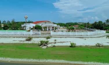
Historical relic of Ben Au Lau
Au Lau Wharf (now located in Au Lau commune and Nguyen Phuc ward, Yen Bai city) is an important place to transport officers, soldiers, citizens, food and weapons to serve major campaigns. during the resistance war against the French colonialists, paving the way to the victory of the Dien Bien Phu campaign, restoring peace in the North in 1954. In 1953, the ferry wharf where people along the Red River traveled back and forth to exchange and trade was built into the Au Lau ferry wharf. Au Lau ferry terminal is a convenient connection point between Viet Bac and the Northwest of the country. From the early days of the resistance war against the French colonialists, Au Lau wharf was the place to gather and secretly transport revolutionary cadres and soldiers to prepare for the general uprising and then establish the Revolutionary Committee. temporarily and took over Yen Bai town. It was also here that the French colonialists escorted political prisoners from Nghe An (1943) and Thai Nguyen (1945) to prison at Cang Nghia Lo. On the night of August 16 and 17, 1945, according to the plan, the Au Lau Guerrilla Revolutionary Military Committee and the Au Co Guerrilla (Van Hoi) along with the soldiers on the right bank of the Red River crossed the river to attack the Security Camp to seize the government from their hands. Japan. In 1951, during the Ly Thuong Kiet campaign, one direction of the 312th Division crossed the wharf to attack Nghia Lo military zone (October 3, 1951). The Northwest Campaign took place on the night of October 10-11, 1952. Au Lau wharf was one of four wharves where the 36th regiment, 174th regiment of the 316th regiment and the 308th regiment crossed the Red River into Ca Vinh, Ba Khe, and Pass. Hong attacked Cua Nhi base. At the end of November 1952, according to the instructions of the Party Central Committee and the General Command, it was requested to urgently expand route 13 from Viet Bac through Yen Bai. Despite difficult circumstances and fierce enemy bombardment, we still opened the road 13 early 5 days through Au Lau wharf to provide reinforcements for the Northwest battlefield. Au Lau wharf has an important position connecting the Viet Bac transportation system with the Northwest, and is the only place where heavy weapons can be hoisted such as: ground artillery, anti-aircraft artillery, cars carrying ammunition. , military equipment crossed the river to reinforce the Dien Bien Phu battlefield. During this time, Au Lau wharf was reinforced in terms of both manpower and facilities to transport weapons, ammunition, food, foodstuffs, citizens, and soldiers across the Red River, and at the same time brace itself against the battles. fierce bombing by the French colonialists. At night is the time when most activities take place at Au Lau wharf to avoid enemy detection. Ferries travel back and forth as quickly as possible to clear the way for reinforcement vehicles. To prevent sabotage by enemy aircraft, during the day we had to drag the ferry upstream to Ngoi Lau to submerge the ferry, and at night we had to flood it again and pull it out. From November 1953 to May 1954, the French colonialists focused fierce bombardment on Au Lau wharf for more than 200 days and nights with 2,700 tons of bombs and ammunition, but we were only able to transport thousands of tons of food and goods for only 8 days and nights. hundreds of tons of ammunition and weapons for the Dien Bien Phu front. After serving the Dien Bien Phu campaign, from 1955-1965, the wharf was upgraded from a wooden ferry to a steel ferry with iron canoes. In 1965-1968, with the spirit: "Living by the bridge, dying courageously" the wharf 100 times brought 500 trucks across the river, transported nearly 200,000 cars, and thousands of tons of goods back and forth. During the years of fighting against the destructive war of the US imperialists, they used many groups of planes to attack for 4 hours, causing heavy damage to Yen Bai town and Au Lau ferry port on May 31, 1966. In 1967, Au Lau Wharf was honored to be visited by Prime Minister Pham Van Dong on the occasion of wishing New Year to the troops and people of Yen Bai and Nghia Lo provinces. On December 18, 1972, the American enemy continued to raid Yen Bai, including Au Lau wharf, but still could not stop ferries carrying people and food supplies to the southern battlefield. After the country was unified, Au Lau ferry continued to operate and became a key unit of the transportation industry in Yen Bai province. On August 7, 2012, Au Lau Wharf was recognized by the Ministry of Culture, Sports and Tourism as a national historical relic. Source: Yen Bai province electronic information portal
Lao Cai
5522 view
Rating : National monument
Place where Khau Pha guerrilla team was founded
Khau Pha guerrilla team (Cao Pha commune, Mu Cang Chai district) was established in October 1946 at Trong Tong Khua village on the top of Khau Pha pass (previously it was an armed team established in 1944 by the Vietnamese people). Hmong people to fight against the oppression and exploitation of the rulers, then became the armed forces against the Nationalist Party). Initially, the force had only 7 members and only 3 self-made guns were weapons: flintlock guns, sharp knives and bows and crossbows. After a period of fighting, the guerrilla team grew very quickly in number, up to 30 people, 50 people and then at its largest number of more than 200 members, the participating forces were mostly local people (Hmong people). ). This is a relic located on a rugged mountainous area, stretching from the foot of Cao Pha pass to the top of the pass (over 20km long). The guerrilla team's area of operation is wide, with many locations, including the three most important locations, where important events took place during nearly 8 years of operation of the Khau Pha guerrilla team. They are: Tong Khua Drum Village - where the Khau Pha guerrilla team was founded;. Mr. Ly Nu Chu's house - the revolutionary base of the Khau Pha Guerrilla Team (Lim Mong village) and Bat Cave - the site of the French ambush at the foot of Khau Pha pass, in 1948. During the years of operation (1946 - 1952), the guerrilla team fought many battles, causing France many difficulties and losses. Established in 1946, the Team not only organizes training but also performs the duty of guarding and protecting the people and protecting production at the top of the pass while relying on the rugged mountain and forest terrain, coordinating with the main force and the army. The local team heroically fought the enemy, achieving many outstanding victories. On October 8, 1947, the enemy swept and attacked Khau Pha. Under the command of Captain Ly Nu Chu, the guerrilla team used a small force to fight back, killing a second officer and wounding many French soldiers, forcing the enemy to abandon the operation. During the period 1947-1949, the guerrilla team starved and thirsted many times, lived in the forest, ate brown tubers and grated tubers, determined to fight the enemy. During these arduous years, the Team achieved many remarkable achievements. Typically, in the battle of Nam Khat, a guerrilla team ambushed, shot and ran away an enemy company, capturing 2 guns. Next, in two consecutive battles in Gia Hoi and Tu Le, the guerrilla team coordinated with the army to chase the enemy, capturing 2 guns, many mines and grenades. In March 1948, the guerrilla team coordinated with the Quyet Tien Assault Team led by comrades Hong Quan and Ly Bach Luan to organize an ambush to attack the enemy on the Tu Le - Gia Hoi road, capturing 3 rifles. and some ammunition. At the end of March 1948, the Inter-Zone Party Committee and the Inter-Zone Command 10 decided to open the Nghia Lo campaign, with the Khau Pha guerrilla team coordinating with Company 520 and the Quyet Tien assault team to attack Tu Le post and capture them alive. named Bang Colonel Lo Van Inh (commander of the station), and at the same time disbanded a unit of 27 soldiers, confiscating 2 machine guns, nearly 20 rifles and a number of other weapons. After this victory, the team was equipped with 50 more guns. Since 1949, realizing the effectiveness of the Khau Pha Guerrilla Team, the enemy became more and more terrorist, they tried to concentrate the population and strictly control the terrain. Therefore, the team's activities encountered many difficulties: lack of food, ammunition, complete loss of contact with the Party, the government, and the army, but still remained absolutely loyal, persistent, and fought continuously. custom. After 1951, France fiercely attacked our facilities in the enemy's rear area, most of them were disintegrated. But with courage and tenacity to hold on, the Khau Pha Guerrilla Team still maintained the fight, causing many losses to the enemy. The team has become an important connection point located at Mu Cang Chai gateway, connecting revolutionary bases in the region with the two ends of Nghia Lo - Than Uyen. In October 1952, the General Command launched the Northwest campaign to liberate Nghia Lo Subdivision and the subregions of Than Uyen, Phu Yen, and Son La. On October 16, 1952, the enemy parachuted a battalion into Tu Le, Cao Pha, but it was destroyed and pursued by a guerrilla team coordinating with the main army. On October 15, 1952, Than Uyen was liberated. On October 18, 1952, the enemy failed miserably in Nghia Lo Subdivision and found a way to flee to Son La. The remnants of the enemy army passing through Cao Pha were pursued and destroyed by guerrilla forces. Mu Cang Chai was completely liberated from French colonial occupation. On August 27, 2012, the place where the Khau Pha guerrilla team was founded was recognized by the Ministry of Culture, Sports and Tourism as a national historical site. Source: Yen Bai province electronic information portal
Lao Cai
5563 view
Rating : National monument

Nhuoc Son Temple
Located on the banks of the Red River, about 41 km from Mau A town, Van Yen district (Yen Bai) along provincial road 151 to the Nhuoc Son Temple Historical - Cultural Relic Area. This relic area in Ngoc Chau village, Chau Que Ha commune, is the temple to worship general Ha Chuong - a real figure in history, a talented martial general during the Tran Dynasty - who made great contributions to the defense and control of the war. kept the northern border area, contributing to our nation's glorious victory over the Yuan Mongol invaders. The relic site was classified as a national historical-cultural relic on November 16, 2005. Every year, on January 20 and September 20 (lunar calendar), local people eagerly prepare to welcome tourists from all over. Recently, not only local people, in the district, in the province but also many tourists from Hanoi and other provinces come to the temple. In the past two years, Nhuoc Son temple restored its festival activities and attracted more and more tourists from all over. Local people call Nhuoc Son temple by another name: Loong Meac, At Meac. According to "Records of Nhuoc Son Temple Relics" (Hoang Tien Long, Yen Bai Provincial Museum), in February of the year Dinh Hoi 1287, more than 300,000 Yuan Mongol troops attacked our country, the Yuan Mongol army led by Nat Toc Lat Dinh When the commander fled through Phu Ninh area, he was blocked and attacked by the local army and people led by brothers Ha Dac and Ha Chuong. When chasing the enemy to A La, the brothers Ha Dac and Ha Chuong were blocked by the enemy's rear army, Ha Dac heroically sacrificed his life, and Ha Chuong was captured. Taking advantage of the dark night and the enemy's loopholes, Ha Chuong took the enemy's flag and uniform to escape, asking the court to use the flag and uniform to pretend to be the enemy's soldiers at their camp. When the enemy was suddenly attacked, they were unable to take precautions and were attacked from the inside by Ha Chuong's army. The Mongol Yuan army was broken and withdrew its remaining troops to Yunnan. According to the genealogy of the Ha family, they were originally Tay Khao people, belonged to the Ha Dac and Ha Chuong lineages during the Tran dynasty, now residing in An Boi, Kien Xuong district, Thai Binh province. When fighting the Yuan army, Ha Chuong enthusiastically pursued the enemy. went to Yen Bai area and sacrificed. According to the elders in Chau Que Ha commune, Ha Chuong, during the second resistance war against the Mongol Yuan army, chased the Yuan army along the Red River to Yen Bai, arriving at present-day Chau Que Ha to recruit more soldiers to continue the pursuit. attack and destroy the enemy army. During the decisive battle, Ha Chuong was seriously injured, sacrificed and was taken to the river to be buried at the mouth of Nhuoc Son waterfall.... Source: Yen Bai province electronic information portal
Lao Cai
5008 view
Rating : National monument

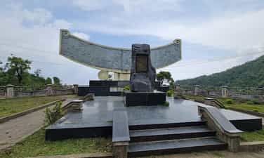
Lung Lo Pass
Lung Lo Pass belongs to Da village, Thuong Bang La commune, Van Chan district, Yen Bai province, the pass is also known as Dao Pass. Lung Lo - a place that has entered the history books during the nation's heroic resistance war against the French as a legend. Here, the army and people of the whole country devoted their efforts to supplying supplies to the Dien Bien Phu battlefield through Lung Lo pass. Lung Lo Pass is located on National Highway 37 (old Road 379, connecting National Highway 32 with National Highway 32B) at the border of Van Chan (Yen Bai) and Phu Yen (Son La) districts, located northeast and far from town. Phu Yen33 km. The pass is 15 km long, from km 349 to km 364, with a slope of 10%. During the resistance war against the French colonialists, the Party Central Committee decided to open road 13A starting from Ben Hien, Tuyen Quang province, passing Ben Au Lau, passing Lung Lo pass to Co Noi intersection, connecting with road 41 Phuc service for the Dien Bien Phu campaign. The route that the engineers and civil workers had to open was over 120km long, the terrain was mainly high mountains and deep abysses, and had to pass through three large rivers: the Chay River, the Red River and the Da River. Clearly defining the political task of ensuring smooth traffic flow to the battlefield, as early as April 1953, at the request of the General Staff, Yen Bai province decided to establish route 13, mobilize 124,458 people participated in paving the road with 173,197 people digging, filling and leveling bomb craters to prevent landslides. Local people voluntarily donated thousands of trees, tens of thousands of bamboo trees, bamboo trees, bamboo poles, and house pillars to line roads, build bridges to open traffic, and transport military food into the campaign. After more than 200 days and nights, our army and people paved the way, protected and transported thousands of tons of food, military equipment, weapons and ammunition to safety. The route through Lung Lo Pass was smoothly connected to the Viet Bac war zone and the Northwest provinces, serving the Dien Bien Phu campaign, thanks to which tens of thousands of cars and carts carrying weapons and goods provided timely and adequate support to the soldiers. battlefield. Faced with that situation, in February 1954, the French colonialists concentrated their air force on fierce attacks on the roads to the Northwest, in order to prevent reinforcements from the rear to the battlefield. Along with Au Lau, Hung Khanh, Vuc Tuan, and Co Noi, the Lung Lo pass location is where the enemy dropped nearly 12,000 tons of bombs, some days the enemy dropped 200 bombs. During the campaign, 16 to 18 enemy planes bombed 5 to 6 times every day. Overcoming danger, despite falling bombs and explosions, with the spirit of all serving the front line, tens of thousands of people and citizens stuck to the road day and night. The enemy destroys, we correct ourselves, the enemy destroys this section, we open another section, the enemy destroys during the day, we open the way at night. Tens of thousands of tons of food, military equipment, weapons and ammunition, tens of thousands of tons of food and foodstuffs gathered in the Thuong Bang La area crossed the pass into the battlefield and were safely protected. With a heavy task and urgent time, the supply road to Dien Bien Phu through Lung Lo Pass was completed 10 days ahead of schedule and became a historical miracle, surprising and terrifying the French colonialists. brave spirit of our army and people. From the solidarity and unity in labor and fighting of officers, soldiers and people of all ethnic groups in Yen Bai province, Road 13A - a historical and cultural road was formed, making a positive contribution to the war. Dien Bien Phu victory and the process of socio-economic development of the two provinces of Yen Bai and Son La. Later the road was named "National Highway 13A" - historical road. Lung Lo Pass - a legendary road, was recognized and ranked as a national historical relic by the Ministry of Culture, Sports and Tourism in 2011, on the occasion of the 57th anniversary of the Dien Bien Phu Victory (May 7. 1954-May 7, 2011). Source: Yen Bai province electronic information portal
Lao Cai
4786 view
Rating : National monument