Relic point Vietnam
Việt Nam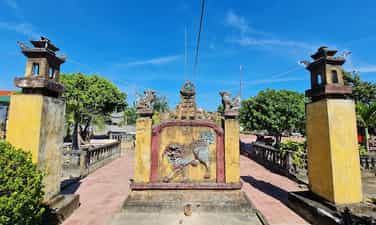
Ong Pagoda
Ong Pagoda (Quan Thanh Tu) is located in the town of Tu Thu Xa, Nghia Hoa commune, Tu Nghia district, 10km from Quang Ngai city to the east. The pagoda was made by 4 states of Hoa Minh Huong (Fujian, Trieu Chau, Hainan, Guangdong) living in Thu Xa Kien area in the second Minh Mang year (1821) and has undergone 4 restoration in 1881, 1894, 1920, 1991. Ong Pagoda worships Quan Vu in the main hall, worshiping Avalokitesvara Bodhisattva (people of China and Vietnam called Buddha Quan Am Nam Hai) in the harem space in the model of "Money Holy Buddha". In addition, the harem also worshiped Thien Hau, Kim Dau and 12 midwives. In terms of scale, although Ong Pagoda seems humble compared to the temples worshiping Quan Cong in Hoi An (Quang Nam), there is a harmonious combination of flower -Vietnamese architectural elements in a whole rich aesthetic. According to the profile of the General Museum of Quang Ngai province, the pagoda has a total area of 2,730m2, including temple garden, Tam Quan, pagoda yard and pagoda. All are surrounded by round 1, 1.2m high, 0.5m thick in a parallel style. The pagoda turned to the east. From the outside, the architectural works are arranged on a trary axis, tightly layout, posted in sequentially including: Tam Quan, Binh Phong - Tieu Tieu, Trong - Bell floor and temple. On both sides of the facade, there are two low gates, behind the temple is the temple to worship Tieu Dien Sy. Tam Quan gate structured one space, four columns, two sets because of the anti -fruit, in the way of the diaphragm. The third diaphragm bends the shape of the boat decorated with the head of the phoenix tail. The diaphragm is linked through the husbands and gloking through the column head. The roof of the tam tile roofed with yin and yang tiles, the top of the boat bent the boat, decorated the dragon shape, the tail covered with vegetable vines. The roof is decorated in the form of a box with five decorative cells. The two sides of the three gate are the temple of Ba Thien Hau. Battan Phong 2m high, with three compounds, the front covered with tiger shaped tiger bared the tail to look very vivid, the back covered the shape of the glass on the roof cluster. On both sides of Binh Phong are two pillars. Bell floors, drum floor built posted through the axis. Ong Pagoda currently holds 6 steles, epitaphs of Han characters, created in 1895 (7th Thai Thanh), 1920 (5th Khai Dinh), which are the years when the temple restores. Decorative stone stele touches the dragon painting in the forehead, the brazen beer is decorated with the dragon's head wrapped in a vegetable vine. The epitaph records the list of people who worship the money, including the name of the person, the place of residence, and the amount of money. In general, the art of decoration at Ong Dat Pagoda is quite sophisticated, especially the technique of embossing, touching, puncturing, touching on the screen, wooden walls, worshiping, trap, pattern, husband, statue, briefcase ... Ong pagoda has a harmonious combination of architectural elements of Vietnamese and Chinese people. In addition to the main components and materials of the traditional communal house in the Central region (the baseballs' husbands, the fake husband's husband) also has the appearance of the hiding of the planet of the Northern Delta and the set of the pumpkin husband's style of the North China style. Ong Pagoda was recognized by the Ministry of Culture and Sports (now the Ministry of Culture, Sports and Tourism) to recognize the national monument under Decision No. 43 of the Culture/Decision on January 7, 1993. Source of Quang Ngai Electronic Information Portal.
Quang Ngai
3732 view
Rating : National relics.
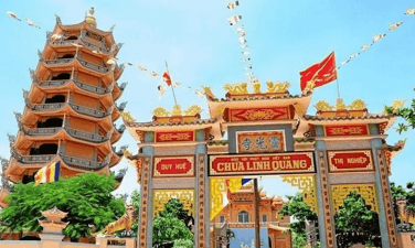
Linh Quang Pagoda
Since creating up to now, people on the island called the temple name "Linh Quang Tu" to pray for the glory and light of the temple always enlightened to save the people on the island to have a peaceful and happy life. Linh Quang Tu is the beginning of the temple associated with the spread of Buddhist light in Phu Quy. Not only is a beautiful place, but Linh Quang Tu is a typical temple in the fields of historical, literature and art compared to other temples on the island. Linh Quang Tu is a famous ancient temple in terms of scale as well as architectural art, religion, ritual, with diverse natural scenes that deserve to be the famous landscape of Phu Quy Island. If the official chronology of the temple followed the genealogy, the pagoda was created and renovated in the year of the Rabbit 1747 of King Le Hien Tong - the 8th Canh Hung dating. Up to now (2017) the temple has dated 270 years and so far this is one of the earliest temples in Binh Thuan. With these typical values and meanings, Linh Quang Pagoda was ranked by the Ministry of Culture and Information Ranking of the National Landscape in Decision No. 51 Decision/Minister of January 12, 1996. Source of electronic portal of Phu Quy district, Binh Thuan province.
Lam Dong
4144 view
Rating : National relics.

Mui Ne white sand hill (Bau Trang)
Bau Trang (or Bau Cat, Bach Ho, Bau Sen) is a freshwater lake in Binh Thuan province, about 62 km northeast of Phan Thiet city, in Hong Lam village, Hoa Thang commune, Bac Binh district (formerly in Binh Nhon commune, old Hoa Da district). According to legend this place is a large lake, after the people cover the sand dam and run across the lake to pass. This large lake has since been divided into 2 parts: Tieu Ho and Dai Ho. Because "Bau" in the local language means "lake", for a long time, the local people have called Tieu Ho as Bau. In 1867 when Ho Chi Minh passed by here, seeing the beautiful scenery of Bau Trang that he called "Bach Ho". "Bach Ho" began to appear in Nguyen Thong's poetry and also from there became the poet who assigned Bau Trang. Bau Trang is divided into 2 parts by a sand hill across. The people here have been called Bau Ong and Bau Ba. Bau Ba is larger than Bau Ong and contains more water. The depth of Bau Ba is 19m in the rainy season. Around Bau Ba planted a lot of lotus. Lotus is planted by residents for the purpose of harvesting seeds and looking. Because of planting lotus in this area, the landscape is more special. Small than Bau Ba, but there is a dike separating the two lakes. Bau Ong is more shallow and not as sweet as Bau Ba. Possessing a rare natural beauty, Bau Trang is a famous sight that most tourists cannot ignore when choosing Binh Thuan is a resort, sightseeing, entertainment. With a total area of about 45 hectares, the tourist destination consists of 23.2 hectares of 3 types of forest types managed by Le Hong Phong Protection Forest Management Board, the remaining 2.8 hectares of land and 19 hectares of water surface managed by the People's Committee of Hoa Thang commune. In 2013, this place was recognized as a place in the top 100 impressive destinations of Vietnam, in the period of 2014 - 2016, continuing to receive the title of ASEAN favorite destination and the top 100 favorite points in the South. Especially in 2019, Bau Trang was honored to receive the ranking of national landscapes at the decision of the Ministry of Culture, Sports and Tourism. Source of information portal in Bac Binh district, Binh Thuan province.
Lam Dong
4107 view
Rating : National relics.
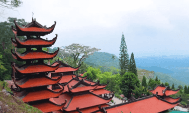
Ta Cu mountain pagoda
Ta Cu mountain pagoda (locals or simply calling the mountain pagoda) is a temple located on Ta Cu mountain at an altitude of more than 400 m, in Thuan Nam town, Ham Thuan Nam district, Binh Thuan province, near Highway 1, 28 km south of Phan Thiet. This pagoda is a national historical and cultural relic of Vietnam. In the middle of the 19th century monk Tran Huu Duc (1812-1887) Dharma name Thong An, Huu Duc's Dharma from Phu Yen to Binh Thuan built a draft in Kim Thanh village (Bau Tram) who had just practiced and picked medicine. He used to practice and contribute a lot of effort to take care of Buddha in many pagodas in Binh Thuan such as Co Thach Pagoda, Linh Son (Tuy Phong), Phuoc Hung (Phan Thiet) and some pagodas in Phu Quy island. In 1872, the monk went to Ta Cu Mountain to practice in a rock cave (later called the nest cave). Until the time of death, Master Huu Duc did not go down the mountain anymore. At the same time, the monk Huu Duc was a good physician. In the 33rd year of Tu Duc (1880), the Empress Dowager was seriously ill, the gods asked to receive the monk to help treat the disease but the monk refused, only sent people to the court. The Empress Dowager was gone, King Tu Duc gave the name of the pagoda, Linh Son Truong Tho and the monk was "Venerable Venerable". Until the monk Huu Duc President passed away (on October 5, 1887 in the lunar calendar), the Master Tam Hien set up a new temple below, later called the lower pagoda or Long Doan pagoda and Linh Son Truong Tho pagoda as the temple. Above the temple, about 50 m from the nest cave is the statue of Shakyamuni Buddha, 49 m long, 7 m high. The work was chaired by Mr. Truong Y, casting with reinforced concrete in the restoration of 1963. About 50 m from the bottom is the Tam Ton Ton Ton statue group, built on the lotus: A Amitabha statue in the middle of 7 m high, the left is the statue of Avalokiteshvara and the right of Dai The Chi statue is 6.5 m high. The tomb tower of the ancestors and the abbot of the abbot was divided into two clusters in front of the church and after the temple. The nest tower is located in front of the temple, besides the tomb of the tiger, it is tamed by Master Huu Duc. Source of portal port of Binh Thuan province.
Lam Dong
4344 view
Rating : National relics.
Tu Luong communal house
Tu Luong communal house was called by the name of Tu Luong village before. At the beginning, the communal house built with simple leaf paintings and gradually decades after that they were embellished in a solemn appearance. Like other communal houses in Binh Thuan, Tu Luong communal house is created by all the incense and people in the village. In 1995 - 1996, through surveys, comparison from architectural structure, construction techniques, art decoration art, the remaining ancient relics in the communal house and the genealogy of some people who settle down for a long time Life in the village, museum and Department of Culture and Information Binh Thuan determined to create Tu Luong communal house in the early nineteenth century. Currently, the communal house is located in Duc Long ward, about 1.5 km southwest of Phan Thiet city center. According to Mr. Nguyen Huu Tu - Head of Management Board of Tu Luong village communal house, at the beginning, Tu Luong is one of the villages with an ideal position, convenient for business and early economy. Dinh in Phan Thiet. In Tu Luong communal house, there is still a picture of the ancient horizontal screening of Han characters clearly about the geography and landscape of the village. The architectural complex of Tu Luong communal house at the beginning of creating quite a large scale, the superficiality includes the temple of the god, the road, the three gate, the gate, the room, the worshiping space And the wall surrounded. Tu Luong communal house has a unique architectural structure, here using two typical local folk architecture forms, which are the "four -pillar" and "coincidence" architecture combined . In architectural structure, wood, bricks play an important role. In which wood is the main material to create the link frame of each roof of the communal house, followed by the blending mortar with folk experience from lime, shells, sand, molasses, asphalt ... to make The adhesives build solid walls and solemn and ancient communal houses. The roofing materials and floors are still reserved, which are ancient yin and yang tiles and Bat Trang bricks that were commonly used in folk structures at that time in the locality. In addition, in the communal house, there were 2 bronze casters dating back to the late nineteenth century. Both Dai Hong Chung plays an important role in Dinh's annual music reconciliation. 6 Dragon examination, 4 incense, 3 covers and 2 mail projects. These are precious wooden -made, carved, elaborate and sharp relics. These relics have an important function in the decoration of worship in the interior. 20 diaphragm and 16 couplets, the whole carved ancient Han characters on good wood. Each picture has different sizes, some have the border around the image of Giao Long, elegant flowers. The content of praising the authority of the god, passing on to the descendants of the great gratitude of grandparents and ancestors; The generation only follows the fine customs and fine traditions of the nation ... Tu Luong communal house was ranked by the Ministry of Culture and Information of the National Architectural Architecture Monuments in 2001. This is the place where folk festivals take place in cultural space. Every year, the communal house organizes many sacrifices. The biggest are two Le Xuan Thu Ky in February and August of the lunar calendar. Through this, today's generation understands more about the local history, from which to be aware of preserving the good cultural value of the ancient ancestors. Source of electronic portal of Duc Long ward, Phan Thiet city, Binh Thuan province.
Lam Dong
4194 view
Rating : National relics.
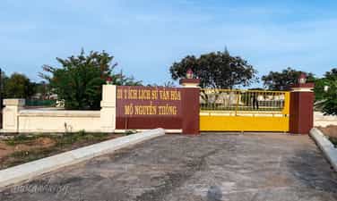
Temple and tomb area of Nguyen Thong
He was born on May 28, 1827 in Binh Thanh Village, Thach Hoi Ha General, Tan Thanh District, Tan An District, Gia Dinh Province (now Phu Ngai Tri Commune, Chau Thanh District, Long An Province), whose name is self. Hy Part, Ky Xuyen, Nickname Am. . Smart, eager to learn but Nguyen Thong soon orphaned. With his rise efforts, he was a monk. When France invaded Cochinchina, he and his scholars here refused to cooperate and go to the land in Binh Thuan. His whole life, he wholeheartedly worried about the country, for the people ... When he was 10 years old, his mother died. 7 years later, his father also died. His family has since fallen in misery, so Thong has to make a living to take care of the whole family. Eager to learn but there is no teacher with the couple, so the two brothers have to study themselves. Until Mr. Nguyen Nhu Hien was appointed by the court to work in Tan An, the two brothers came to ask for life. The time of studying Mr. Hien was not long, the teacher was sent to the capital. In 1849 (in the Year of the Rooster, the reign of King Tu Duc), Nguyen Thong passed the bachelor's exam, but by the festival, he was dropped just because of the reason that the test was covered with ink. Also because of the poor family, Thong could not continue his career in book lights and he received the training in Phu Phong - An Giang Province. In 1855, he went to Hue, and then a year was promoted to the Academy of Division, in the cabinet, participating in the preparation of the book "Human Resources Kim" (the golden mirror illuminated the human work). When France invaded the Southeast of the Ky in 1859, Nguyen Thong volunteered the army and worked as a powerful advice for the Governor of the Military Service of Ton That Hiep, looking after the secret work. Chi Hoa station was lost in 1861, then Bien Hoa province was also occupied by France. After fighting in the peaceful battle, his brother Trinh Quang Nghi and his friend Phan Van Dat recruited the Mo Nghia to fight against the French army in Go Cong and Tan An. Nguyen Thong participated in that movement. Phan Van Dat was killed by the French, and Thong was lucky to escape. The following year, Mr. Truong again helped Truong Dinh very effective in the position of military service. In 1862, France forced us to cede 3 Eastern provinces, thanks to Phan Thanh Gian nominated, Nguyen Thong was appointed as the Doctor of Vinh Long. Here he still kept in touch with him, and still contacted the patriotic scholars, including the scholars who moved their families from the East to. At the same time, he rebuilt Van Thanh Temple of Vinh Long. In 1867, France used to occupy Vinh Long citadel, he and many Nam Ky scholars refused to cooperate, so they went out in Binh Thuan. Nguyen Thong and his comrades discussed the investigation and contact with Bien Hoa, and also actively developed agriculture and food production for long -term concerns. He himself organized the exploration of La Ngu and Ba Dau plateau (Binh Tuy), stating the terrain and terrain of the ability to reclaim and draw clearly the map. After that, he was mobilized to Khanh Hoa, then went to Quang Ngai, Hue. At the end of 1867, he was a project close to Khanh Hoa province and offered to award the name of Thuy to Phan Thanh Gian and hearing 4 issues of benefit of the country but was rejected by the Hue court. In 1870, Nguyen Thong made an argument for the image of Quang Ngai. Especially in Quang Ngai for 3 years, he has done many things to benefit farmers, especially irrigation. At the same time, he was involved in an unjustly accused of being sentenced to the court, so he was dismissed by the court, imprisoned into prison and trial. The people and soldiers all loved him so he asked Quan Kham Sai Nguyen Binh to take office in Quang Ngai to review his crime. Some people voluntarily come to the city to meet the king to complain to him. The king of love should forgive him and for the new investigation or this incident was because Cuong Hao Le Doan accused him of him. During this time, he was accepted by the court two aspirations, namely: Organizing planting trees and defining the history of history, please issue a book to study schools. In 1876, he returned to Hue to work as a career in Quoc Tu Giam. He and Mr. Bui Uoc and Hoang Dung Tan approved the "Kham Dinh Viet history". And also on the occasion of the Hue capital this time, he composed the "Vietnamese history of judges". At the same time, he offered and prepared to exploit the Central Highlands from the Cambodian border to Quang Tri, to collect the people of the South. But in the end this was opposed by the French, so the Nguyen court ordered to abolish it. In 1880, Nguyen Thong was the deputy vice -artist and the Doctor of Binh Thuan Province, he also discussed with the compatriots of the countryside. Binh Thuan after running from the South. He built a small house next to the Phan Thiet River (now the area of Duc Thanh relics), named Ngoi Du Sao (the team is playing) to read books, write poems, on the wall, there are some typical scenes that Mr. Trai's life. He officially considered Binh Thuan as his second home. In 1884, Nguyen Thong died. His tomb was built at the foot of Co Mountain (Ngoc Son Mountain) in Ngoc Son village - Phu Hai ward - Phan Thiet city - Binh Thuan. The tomb of Doanh Dien Porcelain Binh Thuan Nguyen Thong was built quite simply and close. The tomb has a length of nearly 9 and a half meters, nearly 6 and a half wide. The main part of the tomb covers the unicorn like the ancient tombs of the ancient people. Around the tomb is very beautiful ornamental plants, looking at the tomb of Doanh Dien Binh Thuan now looks very monumental. This tomb area was ranked by the State in 1999. , historian ... Nguyen Thong for our nation. Source of electronic portal of Phu Hai ward, Phan Thiet city, Binh Thuan province.
Lam Dong
4388 view
Rating : National relics.
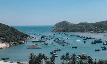
Landscapes of Vinh Hy Bay
Vinh Hy Bay is located in Vinh Hai commune, Ninh Hai district, Ninh Thuan province. Vinh Hy means the desire to trade busy, bustling with many opportunities, lucky, towards a peaceful, happy and peaceful life. Vinh Hy Bay is also known as Vung Cai and Vung Gang. Vinh Hy Bay is about 42km northeast of Phan Rang - Thap Cham city center. This place is one of the destinations that attracts a large number of tourists and was included in the project "Building and developing a key tourism route in Ninh Thuan province", including: Pottery village. Bau Truc, My Nghiep weaving, Po Klong Garai tower, Thai An vineyard and Vinh Hy Bay. Vinh Hy Bay is a landmark that has been established by the Vietnam Record Organization in the top 10 most beautiful bays of Vietnam, in the overall planning of Vietnam's tourism development to 2020 and a vision to 2030. Vinh Hy pier goes in the left direction for about 5 minutes of sea, will first meet the inner and outside toad beach. This is a rocky beach that floating the water with the shape of a toad is "God". Next is the nose of the whale, also known as the tip of the Tay Sa, is the image of a giant whale protruding up the water, towards the sea as calming and protecting silently to bring peace to the The sea and land of Vinh Hy. This is the work of nature, the creation of mountains and sea, but for the people of Vinh Hy, it also has deep spiritual meaning. Because whales or fish are ordained by the Nguyen Dynasty with the title of Nam Hai Cu Cu Tribe Ngoc Lan Ton Than and the people here always respect his fish because of the efforts to protect, protect and bring luck luck for bumper crops. Next is Hon Tai, then the stone mast, Hon Quy is created by nature on the waters of Vinh Hy. Hon Lion) - are beautiful beaches, natural products bestowed on Vinh Hy Bay, with fine white sand, blue sea is the ideal stop for tourists when visiting the bay. Next is a robotic stone location with horizontal and vertical stones on top of each other to create a robot shape. The next destination on the bay is the Yen cave, the place to reside for bird's nest and is also the unique highlight of Vinh Hy Bay. The cave is made up of diverse stones in size, rich in morphology, both rugged and no less vivid, creating a colorful picture of birth is mixed in an improvised way. Next is Ganh Black, Bai Ham, Bai Kinh, Mui Da Wall ... The image of the mountain cliffs is reaching out to the sea. The climate here is tropical monsoon, the average annual temperature is about 27 degrees Celsius, the average humidity of 71%, the bay concentrates many species of fish, shrimp, age spots, ... and especially with many coral reefs Stunning. Located right next to the bay about 10m, there is 1 architectural work of the Nam Hai Lang village of Vinh Hy village, built with solid reinforced cement. The mausoleum has an area of 1,016m2, the length of 36m mausoleum, 28m wide including the works: the gate of the mausoleum, the room, the flagpole, the martial arts ground, the Chief Bai's house, the Tien Hien house, the warehouse, the kitchen, the Thuy Long temple. With the aesthetic values mentioned above, the Ministry of Culture, Sports and Tourism ranked Vinh Hy Bay as a national landscape in Decision No. 44/Decision -The Culture and Sports Culture on 07 /01/2020. Source of cultural heritage.
Khanh Hoa
4187 view
Rating : National relics.
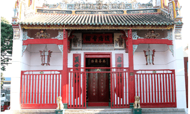
Ong Pagoda
Ong Pagoda has a construction area of 400 square meters located in Kinh Dinh ward, Phan Rang city- Thap Cham. This is the basis for worshiping the holy virtue of the Chinese community with a unique architecture that reflects the peak of the temple building skills of local residents in the late nineteenth century. Ong Pagoda was granted a national monument by the Ministry of Culture, Sports and Tourism on April 14, 2011. Mr. Hang Thai Chau, Head of the Monuments Management Board of Ong Pagoda, said that according to the beer signed at the temple, showing the Chinese people from the provinces of Fujian and Trieu Chau immigrated to Ninh Thuan in the early nineteenth century. In 1831, the people set up a temple to worship the Guan Gong that showed the loyalty to encourage the united, honest and filial Chinese community. The small construction temple is located along the North -South natural road, which is very convenient for traveling to the Chinese community. In 1909, Ong Pagoda was officially restored and built with a large scale of the religious culture of the Chinese people to this day. The pagoda he built in a three -shaped word consists of three spaces: the holy holy world; The temple has a large yard for people to come to worship; The restaurant is a place to exchange for the Chinese community. The system of columns, thunderstorms, and great trusses are carved exquisitely, reflecting the peak in the architectural art of the temple in the late nineteenth century. On the roof of the pagoda is decorated with the image of Mesopotamia; The roofs are carved unicorn, phoenix, flowers lively lines, bright colors. Ong Pagoda also stores many ancient worshiping items with valuable art in bronze, ceramics and worship. And four ordinations of Thieu Tri, Tu Duc and Dong Khanh kings. Ong Pagoda took place annual sacrifices on January 13 of the lunar calendar to worship "Dao Vien"; On the 13th of the lunar month of Quan Binh; June 24, Mr. Quan Thanh. Especially on New Year's Eve, the local Chinese came to burn incense to pray for the nation of the people, the family prosperous in the new year. Ong Pagoda has a beautiful architecture in the center of the city. Phan Rang-Thap Cham is a tourist destination. Source of the portal of Phan Rang - Thap Cham City, Ninh Thuan Province
Khanh Hoa
4102 view
Rating : National relics.
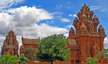
Klong Garai
Klong Garai Po Tower (also known as Klong Giarai Po Tower, Klaung Garai Po Tower, Poklaun Garai, Buu Son Tower), Do Vinh Ward, Phan Rang - Thap Cham City, Ninh Thuan Province. According to the legend of the Cham people, the Klaung Garai tower was made (King Jaya Simhavarman III) for construction to worship Po Klaung Garai - the king has many merits for the Cham people in fighting against foreign invaders, opening ditches, embankment The dam makes the field lush ... Therefore, he has been considered by the Cham people as a king - ultimate god (Shiva) and worshiped in the Klong Garai Po Tower. Po Klong Garai Tower is associated with the history of formation and development of Panduranga - the southernmost land of the ancient Champa kingdom, now in Ninh Thuan and Binh Thuan provinces. Based on beer, architectural style, decorative art, the same artifacts associated with the monument and some other documents ..., it can be believed that, at the current temple position, there was a temple of Siva worshiping tower ( ?), Built in the 11th century, then transformed into the worshiping tower of Po Klong Garai (combined with Siva). That is, Klong Garai Po Tower can now be built on the foundation or renovated and embellished on the basis of an old tower around the end of the thirteenth century - the early fourteenth century. This is a very interesting issue, which needs to continue researching and deciphering. However, with the main object is the Klong Garai Po Tower associated with the function of worshiping Po Klong Garai, we temporarily determined, the current tower dating back around the end of the thirteenth century - the early fourth century. The monument is located on the land with a total area of 86,969.3m2 (protection area I: 1,571.5m2, protection area: II 8,5397.8m2). Within the current relics, in addition to the items of the yard, garden, fence, internal roads, gates (entrance to the relics and the eastern gate), the work complex for tourism - culture, auxiliary architecture Support, temple, architectural ruins ..., and 3 original architecture is relatively complete, including the central tower (Kalan), the gate tower (Gopura) and the house tower. 1.The central (Kalan): is the main worship tower, built on the center of the hill, the largest scale, over 20m high, square pitcher, size 10.5 x 10, 5 meters. 2. Gate tower (Gopura): The tower has a square ground and is a miniature image of the main tower, about 10m high, located in the east of the main tower, opening two doors in the direction worship tower. 3. The tower has a rectangular surface, East -West rotating, 8m long, 4m wide, nearly 10m high. The heart of the tower is divided into two rooms, opened three doors, two doors connected along the North -South axis and one door turned to the east. At the relic, many cultural, religious and beliefs of the community and cross -sights take place, but highlighting and attracting special attention, the Kate - New Year's Festival of the Cham people according to Brahmanism, with many typical ceremonies and performances of the Cham people. No document has not been confirmed, the Kate/Kate festival of the Cham people in our country appeared, but only knew that this ceremony was often followed by the Cham people in Brahmanism in 2 provinces of Ninh Thuan, Binh Thuan. Organized annually on June 30, July 1 to July 10 according to the Cham calendar, corresponding to the period of September, October or November (solar calendar), with the first day on temples - tower ; The second day in the common house of the village; The third day at home; From Wednesday to the end of July 10, the Cham calendar is usually for households. With typical special values, Po Klong Garai Tower Architecture Architecture (Phan Rang - Thap Cham City, Ninh Thuan Province) is ranked as the Prime Minister as a special national monument (in the decision No. 2499/Decision -The General dated December 22, 2016) ./. Source of cultural heritage.
Khanh Hoa
4287 view
Rating : Special national relics.
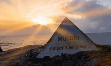
Double Mui - Hon Doan (Hon Dau)
The famous landscape of Mui Doi - Hon Doan (Hon Dau) in Hon Gom peninsula, in Van Thanh commune, Van Ninh district, where the first landing welcoming on the mainland of the country. Mui Doi - Hon Doi (Hon Dau) has two lands protruding into the sea, the farthest nose lies in the coordinates of about 109028’0 "Eastern menstrual period and 12039’0" North latitude. Local people often call it Mui Doi and about 500 meters away, there is a small island of about 20,000 m2 is Hon Dau. Mui Doi - Hon Dau place is known by Khanh Hoa people more on the occasion of Nha Trang Sea Festival in 2005, when together with Nha Trang Bay, the Ministry of Culture and Information (now the Ministry of Culture - Sports and Tourism) ranked national landscapes on March 25, 2005. Thanks to the geological structure, the southern mountains of Truong Son reached out to the East Sea with seawater covered by the sea, so Khanh Hoa waters appeared many islands, large and small, forming many lagoons and bays. Khanh Hoa coast is mostly cliffs accounting for 2/3, the rest is fine sand coast. Therefore, it is the waves from the East Sea that has been invasive, eroding rocky mountains and continental shelf, giving Khanh Hoa coastal area many rocky cliffs, Ganh Da very majestic, impressive and beautiful beaches Beautiful, full of poetic. Among them, the beautiful scenery of Hon Gom peninsula, with a national landscape Mui Doi - Hon Doan (Hon Dau) is a typical. Standing here, we can see boats back and forth on international waters. If you have the opportunity to go to Mui Doi - Hon Doan (Hon Dau), stay overnight to wait for the dawn on the vast East Sea to feel the full beauty of this place. The scenery here has a pristine, fresh natural environment, there is no place like no human footprints. The sky is a vast blue sky. The naked eye can be seen at a depth of the sea tens of meters. Slowered, a few fishing boats along the island and the corners of the sea add to the wild and charming beauty of a island waters. Source of the Ministry of Culture, Sports and Tourism.
Khanh Hoa
4097 view
Rating : National relics.