


List of relic sites (37)

Da Ban historical site
Lang Ngoi - Da Ban historical relic site is a historical place known for the love of solidarity and sharing between Vietnam and Laos. The Lao revolutionary relic is located in Lang Ngoi - Da Ban village, My Bang commune, Yen Son district, Tuyen Quang province. The relics are distributed in two areas: Lang Ngoi area and Da Ban area. The Lang Ngoi area includes relics: Neo Lao Itxala Congress Hall; Comrade Kaysone Phomvihan's residence and work place; Prince Souphanuvong's residence and work; where the Lao army unit lives and works. The entire relic site is located on Go Tre hill and To hill in Lang Ngoi village, My Bang commune, Yen Son district, Tuyen Quang province. The area that has been zoned for protection is: 1,500m2. Here, on August 13, 1950, the National Congress of the Lao Resistance Front took place. More than 100 delegates attended the Congress on behalf of the people of Lao tribes. The Congress elected the Lao Resistance Government led by Prince Souphanu-vong as Prime Minister; Comrade Kaysone Phomvihan, became Minister of Defense (later General Secretary of the Lao People's Revolutionary Party) and elected the Central Executive Committee of the Free Lao Front (Neo Lao Issala) to push Strengthen the resistance against the French colonialists, gain independence and unification for Laos, and build a prosperous and happy life for the people. Through historical changes, the vestiges have been gradually eroded. In order to preserve the historical values, Tuyen Quang Department of Culture, Sports and Tourism has implemented a project to restore and embellish the relic area. Lao revolutionary national history. The project has restored the houses and offices of comrade Kaysone Phomvihane and Prince Souphanuvong; Hall house; restore and embellish the tunnel and trench system; renovate Da Ban cave entrance; renovate the overall beer house; Build a solid bridge across the stream leading to the relic site; Build a house for the Monument Management Board... To further promote the special cultural and historical values of the Lao Revolution national relic site, the Party Committee, government and people of all ethnic groups in Tuyen Quang province have well performed the task of managing and preserving preserve, conserve, embellish and effectively promote the historical values of the relic site; making the Lao revolutionary national historical relic site in Tuyen Quang truly become a symbol of special solidarity and friendship between the two Parties, States and people of Vietnam and Laos. At the same time, do a good job of educating revolutionary traditions, especially for the young generation of the two countries to continue to nurture, nurture and make the relationship between Vietnam and Laos forever close and vibrant. Source: Department of Foreign Information
Tuyen Quang
5671 view
Rating : National monument
Kim Binh relic site
The Second National Congress Relic of the Party (Kim Binh Relic Area), includes 52 points, distributed in 4 communes: Kien Dai, Kim Binh, Vinh Quang, Linh Phu, Chiem Hoa district , Tuyen Quang province. The relic site of the Second National Congress of the Party is a place that marks many important historical events of the nation, such as: The National Congress unifying the Viet Minh Front and the Lien Viet Front into the Inter-Vietnamese Front. Vietnam, People's Alliance Conference of the three countries Vietnam - Cambodia - Laos, Nguyen Ai Quoc School (predecessor of the Ho Chi Minh National Academy of Politics) opens course III, Congress of Emulating Heroes, Soldiers and Cadres the first national model. 1. Relic site of the Party Central Committee and Government's working location, Kien Dai commune. Kien Dai commune is surrounded by a system of high hills and mountains (accounting for 3/4 of the area), the terrain is extremely dangerous, mobile, "convenient to advance, convenient to retreat", is the border area between Tuyen Quang and Bac Kan provinces. . Transportation is mainly by trails and railways (dating back to the French colonial period). Kien Dai base area is covered with a rich and diverse layer of vegetation, convenient for exploitation and construction of camps, houses, warehouses, trenches, and fortifications. Many high mountains surround villages and hamlets, forming a solid wall. There are many caves and caves in the mountain, very convenient for taking shelter when there is an alarm. The people here are mostly Tay and Dao ethnic people, with a spirit of patriotism and early revolutionary enlightenment. With a location that ensures safety, secrecy, and convenient transportation and communication, Kien Dai was the residence and working place of leaders and many central agencies during the period from 1948 - 1952. 2. Relic area of the Second National Congress of the Party, Kim Binh commune. At the end of 1950, after carefully studying the terrain of Kim Binh commune, the Party Central Committee decided to choose the Na Loang hill area, in Bo Cung village, as the place to hold the Party's Second National Congress. Na Loang Hill is located in the center of Bo Cung village, surrounded by many high mountain ranges, such as Pu Choong, Pu Mi, Pu Meo, Trai Face, Kham Khuat, forming a solid and convenient wall. to place observatories and air defense battlefields. The hill is bowl-shaped, the top is quite wide and flat, convenient for building houses and traveling. At the foot of the hill there is Co Linh stream flowing through, which is a source of water for the delegates' daily activities. From Na Loang hill, there are many convenient paths to areas in the Safety Zone. 3. Guard station to protect central agencies, Chinh street, Vinh Quang commune The guard station is a three-room dirt house built with wooden pillars, a roof thatched with palm leaves and double-woven bamboo walls, with one door and two windows. The house is about 3m long, about 2m wide, inside there is a set of tables and chairs to serve the security guard. Currently, only the site remains. 4. Location Na Ma, Pac Hop village, Linh Phu commune The small shack about 20m from the stilt house of Mr. Ha Van Hop's family, where President Ho Chi Minh and comrade Truong Chinh rest, is about 7m long and about 3m wide. The shack is made of bamboo, the roof is thatched with palm leaves, and the walls are double-woven bamboo. The stilt house of Mr. Ha Van Hop's family, where Comrade Pham Van Dong stayed overnight, is a stilt house with 3 rooms and 2 wings, made of wooden pillars, roofed with palm leaves, surrounded by double woven bamboo walls. , there are 2 stairs up and down. Currently, only the site remains. Artifacts of the Second National Congress of the Party relic site are kept at Tuyen Quang Provincial Museum (20 artifacts) such as: tables, chairs in the hall, storage boxes for construction, rice boxes serving the Congress, lunch boxes, and document boxes for delegates. At the Kien Dai Relic Area, there are artifacts: the desk and chair sets of comrade Truong Chinh and comrade Pham Van Dong... Ho Chi Minh National Academy of Politics still retains a number of artifacts such as: desks and chairs. , President Ho Chi Minh's working chair during the Congress... The Second National Congress of the Party took place from February 11 to 19, 1951, which was also the occasion for people of all ethnic groups in Kim Binh commune to organize the Long Tong festival. Therefore, the monument has a close connection with the festival. The relic site of the Second National Congress of the Party has great significance in the work of educating patriotic traditions and revolutionary heroism. With typical special values, the historical relic site of the Party's 2nd National Congress (Chiem Hoa district, Tuyen Quang province) was ranked by the Prime Minister as a Special National Monument. farewell on December 22, 2016). Source: Tuyen Quang province electronic information portal
Tuyen Quang
8359 view
Rating : Special national monument

Cultural and historical tourist destination of the Police Department
The Vietnam People's Police Historical Relic Area (Central Public Security Relics) in Dong Don village, Minh Thanh commune (Son Duong) is part of the Tan Trao Special National Historical Site, where residences and worked for the Central Police Department from April 1947 to September 1950. Previously, all the housing and work of the departments in the Central Police Department were distributed on two large hills, often called hills A and B. These two hills are located next to each other and close to Lung field. Stork. From here you can observe a large area of mountains and villages, convenient for traveling and meetings. Behind the two hills is surrounded by Temple Mountain. The hidden and dangerous terrain is very convenient for protection. This place has witnessed the growth steps of the entire force, where the Central Police Department issued important directives and resolutions, and where historical events of great significance to the People's Public Security took place. August 19 Square is named after the traditional CAND day. Prominent in front of the Square are the Fatherland flag and the Party flag built of natural stone with a strong position leaning against the mountain, representing the desire for the country and the Party to live forever. To show gratitude and traditional education for generations of People's Public Security officers and the Central Public Security Party Committee, leaders of the Ministry of Public Security had the names of 13,689 martyrs engraved on the memorial stele behind the two flags. The monument "Protecting national security", located on top of hill B, in the center of the relic site, has a complete weight of 420 tons. This is a unique cultural work that is not only valuable in terms of history and content but also has value in art, architecture, sculpture... The monument complex is nearly 3,000 m2 wide, made entirely of natural stone with the center being the Monument "Protecting Homeland Security" made of monolithic granite, with a height of 21.6 m, largest diameter of 4.5 m, facing the capital Hanoi. The monument includes 5 characters representing the forces participating in protecting national security. On the top is the National flag, the Party flag and a sword pointing towards the sky. Behind the Monument is a red granite relief depicting 39 events with selected images to most generally represent outstanding activities in fighting, building, and growing up. The People's Public Security force along with the entire people in the cause of protecting national security under the leadership of the Party. The bas-relief is a typical and unique cultural work honoring the process of formation and development of the Vietnamese People's Police. Looking from a distance, the relief can be seen like a cloud radiating a brilliant aura. With the purpose of educating the glorious traditions of the industry for every officer and soldier in the People's Public Security force, in 2010, along with the construction of the relief, the leaders of the Ministry of Public Security decided to engrave the name of the officer. 630 collectives and 336 individuals were awarded the title of Hero of the People's Armed Forces of the People's Public Security force on the gold panel on the back of the relief. Source: Tuyen Quang province electronic information portal
Tuyen Quang
5227 view
Rating : National monument
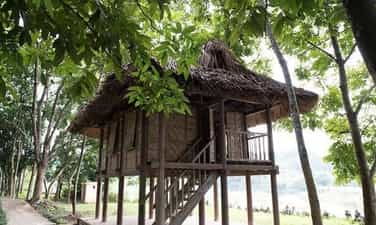
Relics of Comrade Ton Duc Thang's Housing and Safe Tunnel
The relic of Comrade Ton Duc Thang's House and Safe Bunker is located in Chi Lien village, (now Dong Ma village), Trung Yen commune, Son Duong district. Where comrade Ton Duc Thang, Acting Head of the Standing Committee of the National Assembly and Chairman of the Lien Viet Front, lived and worked from the end of 1952 to 1954. The house is located next to the Pho Day River, surrounded by lush greenery. good, helping to facilitate secret communication between places in the region. This is a wooden stilt house with 2 vertical compartments and a palm leaf roof. The outside of the house is the place to work and receive guests; The inner space is where Uncle Ho rests. Close to Uncle Ton's house is a safety tunnel dug about 10m deep into the Chi Lien mountainside, 10m horizontally, with 2 two-way doors. These are two typical relics among the revolutionary historical relics that were once associated with the revolutionary life of comrade Ton Duc Thang in Tuyen Quang during the arduous period of the resistance war against the French colonialists. Kim Quan relic site is more than 40 km east of Tuyen Quang town, spreading in the Na Loi and Vuc Nhu forests, Khuon Dien village, Kim Quan commune, Yen Son district. The Pho Day River surrounds the forest, making it convenient for transportation and living while also ensuring confidentiality. The Party Central Committee office area is 200m northeast of the Government Office. Here, there is a hall, the house of General Secretary Truong Chinh, the house of comrades Hoang Quoc Viet, Le Van Luong and parts of the Central Office: radio station, archives, library, and security guards. Vuc Nhu location where Uncle Ho lived and worked. Uncle Ho's house is a stilt house built on a mountainside. Not far from the stilt house is a shelter. The house is connected to the tunnel by a zigzag trench. The entire office, house, and hall are made of wood, bamboo, leaves... the shelters are dug deep into the mountain, covered with wood on all four sides. Particularly, the basement of the Party Central Committee office area has an exposed section on the outside, this part has a high mound, creating a zigzag-shaped entrance to the tunnel. Kim Quan is also the place where Uncle Ho, the Party Central Committee, and the Government receive international guests. From here, Deputy Prime Minister and Minister of Foreign Affairs Pham Van Dong went to attend the Geneva conference. The relic site has been ranked as a national monument by the Ministry of Culture and Information. Source: Vietnam Travel Association
Tuyen Quang
5389 view
Rating : National monument

Bong Cave
According to the book Historical relics - souvenirs of President Ho Chi Minh on Tuyen Quang land published by Tuyen Quang Department of Culture, Sports and Tourism in 2010, Bong cave, Bong village, Tan Trao commune (Son Duong) This is where President Ho Chi Minh stayed the longest during the resistance war. From a small, simple shack in front of Bong cave, Uncle Ho signed many important decrees, chaired many important meetings of the Government, wrote newspapers, and wrote poetry. During his days here, Uncle lived a simple and pure life, always giving care and love to everyone. At Bong Cave, Uncle Ho lived and worked 3 times: The first time from May 1951 to December 1951, the second time from January to April 1952, the third time from June to the end of 1952. . At Bong cave shack, despite being busy with thousands of jobs, Uncle Ho still spent time playing with the children, increasing production, and practicing sports. Every day, Uncle Ho still went to Pho Day river to bathe. When he returned, he did not forget to bring a few small stones to line the steps to make it less slippery on rainy days. Many touching stories about Uncle Ho's brilliant revolutionary qualities and love for officers, soldiers and people here are still told. From Bong Cave, President Ho Chi Minh set out to the location of the expanded Politburo meeting scheduled to take place on May 25, 1951. It was raining heavily, the stream water rose, he swam across the stream and soaked in the rain to get there. attend the meeting. Also here, Uncle Ho gave blankets and covers to protect the officers from the cold in the middle of a cold winter night, gave rice to the officers to eat to avoid hunger, and told the officers to sleep in the shacks to avoid fatigue. It was Uncle Ho's immense love that urged the cadres who lived near Uncle Ho to overcome all difficulties and hardships to complete the assigned tasks during the resistance war and forever after. Bong Cave Shack is also where Uncle Ho wrote many articles and articles on self-criticism and criticism, preventing bureaucracy, embezzlement, and waste. Three times President Ho Chi Minh lived and worked in Bong cave shack. He worked passionately, enthusiastically, without rest. Many orders and directives were issued and transmitted nationwide, leading the revolution to move forward steadily. Important decisions have changed the battlefield situation, diplomatic relations have been built and strengthened, bringing Vietnam's political position to new heights, financial and monetary work has been focused on creating strength for the resistance economy. From here, he set out on a business trip abroad, going to the front to direct the campaign. Source: Tuyen Quang Newspaper online
Tuyen Quang
4979 view
Rating : National monument

Hong Thai Communal House (Kim Trien Communal House)
Before 1945, Hong Thai communal house was also called Kim Chien communal house in Hong Thai village, Tan Trao commune. The communal house was built to meet the needs of cultural and religious activities of the community and was a place to meet and discuss important matters. common work of the village. In March 1945, under the leadership of the Party, directly comrade Chu Quy Luong, the people of Kim Chien rose up in an armed uprising to seize power. After gaining power, the people met and decided to change the name of the village. The people took the name of martyr Pham Hong Thai as the name of their commune and Kim Chien communal house has also been named Hong Thai communal house since then. Hong Thai communal house was built according to feng shui techniques passed down from ancient times, that is: "earth gathers water, water gathers". In fact, the communal house is placed in the south direction with Thia mountain as the communal house, in front is the Pho Day river, in front of the communal house is a large yard with many old trees such as banyan trees, rice trees... The communal house was built in the 4th year of Khai Dinh's reign, in 1919. The communal house has pure wooden architecture and a palm leaf roof. Overall, the communal house has the appearance of a mountain house on stilts, consisting of three rooms and two wings. The two sides on both sides are used as meeting and dining places, and the three middle rooms are used as places of worship. Above the middle space there is a mezzanine floor, divided into two parts: the upper part is used for offerings, the inside is the palace where offerings are stored. Unlike communal houses in the lowlands, Hong Thai communal house has a very simple architecture. What stands out are the letters painted in black ink at the ends. In addition, in the middle space we also see the image of 6 geckos clinging to 6 columns. In addition to its architectural and decorative value, this is also one of the agricultural beliefs of the people, because they believe that geckos are animals that can predict whether the weather will be rainy or sunny, and from there one can calculate the growing time of the crop. Hong Thai Communal House worships mountain gods around the region. In addition, the communal house also worships a human deity, Princess Ngoc Dung. Every year, the villagers here organize many worshiping ceremonies at the communal house, and the holidays are based on the seasons of the year. On May 4, 1945, Uncle Ho returned from Pac Bo, Cao Bang to Tan Trao. Hong Thai Communal House was the first stop when he arrived at Tan Trao. In August 1945, the revolutionary movement developed strongly, the spirit of seizing power was burning everywhere. Uncle Ho and the Party Central Committee decided to convene the Party's national cadre conference at Tan Trao communal house. Hong Thai Communal House was chosen as the place to welcome delegates to the Congress. All delegates must present documents at Hong Thai communal house before entering Tan Trao. After the success of the August Revolution, Uncle Ho and the Party Central Committee moved to Hanoi. Not long after our country was at peace, the French colonialists broke their promise and returned to invade our country again. The nationwide resistance broke out, the revolutionary homeland of Tan Trao once again welcomed Uncle Ho, the Central Committee, and the Government here to direct the resistance war against the French colonialists. During the resistance period, Hong Thai communal house became the headquarters of the Zone Safety Protection Board. Everyone who wants to enter a central agency to work must go to Hong Thai communal house, present documents, and have the signature of the person in charge to be able to safely enter the area. In addition, Hong Thai communal house was the workplace of the ATK Supply department during the resistance war. After this department moved, many army units were stationed at Hong Thai communal house to train army units. Source: Tuyen Quang Tourism Promotion Center
Tuyen Quang
5408 view
Rating : National monument
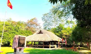
Tan Trao Communal House
Tan Trao communal house is located in Tan Lap village, Tan Trao commune, Son Duong district, Tuyen Quang province. Previously, the communal house was called Kim Long, built in the 6th year of Tu Duc (1853). Tan Trao Communal House was chosen by Uncle Ho and the Party Central Committee as the place to hold the National People's Congress on August 16 and 17, 1945, an important historical event that created the premise for the successful August Revolution. Tan Trao Communal House is a communal house worshiping Thanh Hoang and the river and mountain gods of Tan Lap village. The communal house was built in the year of the Pig (1923) in the style of a stilt house, with wooden columns, 3 compartments and 2 wings, and a roof thatched with palm leaves. Under this communal house, on August 16, 1945, Delegates from all over the country came to meet the National Congress. Here, the Delegates approved the Party's policy of conducting a general uprising, passed the Uprising Order and 10 major policies of the Viet Minh, stipulating that the national flag was the red flag with a yellow star, and the national anthem was Tien Quan. ca and appoint the Vietnam National Liberation Committee, the Provisional Government, chaired by comrade Ho Chi Minh. On the morning of August 17, 1945, on behalf of the National Committee for the Liberation of Vietnam, Uncle Ho read the sacred oath at the National Launch Ceremony here. Implementing the General Uprising order, with the tenacious spirit of the Tan Trao National Congress, the whole country successfully conducted a general uprising to seize power, establishing the Democratic Republic of Vietnam. The Tan Trao National Congress is an important event in the history of the Vietnamese revolution, the second "Dien Hong Conference" in our nation's history. The Tan Trao National Congress was the forerunner of the National Assembly of the Democratic Republic of Vietnam, later the National Assembly of the Socialist Republic of Vietnam. The 10 policies of the Viet Minh are also the premise of our country's first Constitution. Tan Trao Communal House is a red address on the journey back to the origin, a place to educate patriotic traditions and national pride. Source: Tuyen Quang Radio and Television Station
Tuyen Quang
4858 view
Rating : National monument
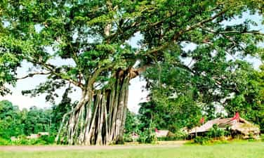
Tan Trao Banyan Tree
Tan Trao banyan tree relic in Tan Lap village, Tan Trao commune, Son Duong district, Tuyen Quang province. Tan Trao banyan tree is a historical symbol of Tan Lap village, where important events took place during the resistance war against the French of the Vietnamese people. This banyan tree is not only the protector of the people here but also a living witness to the heroic days of Tan Trao's army and people. Under the Tan Trao banyan tree, on the afternoon of August 16, 1945, General Vo Nguyen Giap read the Military Order No. witnessed by all Viet Bac ethnic people and 60 national delegates. From then until now, Tan Trao banyan tree has become a revolutionary symbol of the Capital of Tuyen Quang Liberation Zone. The Tan Trao banyan tree has two towering branches that people call the banyan tree and the banyan tree. Both trees are located 10mm apart and have very lush branches and leaves. Through many historical events, the banyan tree gradually ages and weakens. In 1993, due to the impact of a storm, the "banyan tree" fell, leaving only a small branch. The "banana tree" cannot avoid the law of "birth and death", gradually showing bad signs, the leaves turn yellow, and some tops die. By 2008, the Tan Trao banyan tree had only one left branch facing the Northeast of the "banana tree" that was still alive but was not growing well, the main root of the tree was almost dead. Faced with that urgent situation, the local government has coordinated with organizations and businesses to come up with plans to care and revive the Tan Trao banyan tree. With much effort, after 2 years the Tan Trao banyan tree has gradually recovered, more young shoots have appeared, signaling that life will flourish strongly. And to this day, the "banyan tree" has developed into 2 root clusters consisting of 38 large and small roots, with a wide canopy that radiates cool green shade. The small branch of the "banyan tree" has also recovered and grown into a lush new cluster of trees. Tan Trao banyan tree relic is located in the Tan Trao special national relic area of Tuyen Quang province. Source: Tuyen Quang Tourism
Tuyen Quang
7948 view
Rating : Special national monument

Na Nua Shack
Na Nua shack (also known as Na Lua shack) is in Tan Lap village, Tan Trao commune, Son Duong district, Tuyen Quang province. This is where President Ho Chi Minh lived and worked from the end of May 1945 to August 22, 1945 to prepare and lead the August 1945 General Uprising. On May 21, 1945, after 18 days and nights through the forest, starting from Khuoi Nam - Pac Bo (Cao Bang), Uncle Ho returned to Tan Trao, Son Duong district (Tuyen Quang) to prepare for the General Uprising. August 1945. Uncle Ho's first stop when arriving at Tan Trao was Hong Thai communal house. After preliminary grasping the situation and the expected terrain where the Central "headquarters" would be located, Uncle Ho and the officials crossed the Pho Day river into Tan Lap village, Tan Trao commune. Initially, Uncle Ho came to stay at the house of Mr. Nguyen Tien Su, Head of the Viet Minh commune, located in the center of Tan Lap village. At the end of May 1945, Uncle Ho moved to a small shack in the Na Nua forest, in the Hong Mountains. Na Nua shack is located discreetly under dense trees, ensuring secrecy and meeting Uncle Ho's requirements: Close to water, close to people, far from the national highway, convenient to advance, convenient to retreat. The shack is more than 500 meters east of Tan Lap village, about 80 meters from the shack is a trail through De pass, to Phu Dinh - Dinh Hoa (Thai Nguyen); In front of the shack, at the foot of Na Nua forest is Khuon Pen stream. In a small, simple shack in Na Nua forest, Uncle Ho lived and worked from the end of May to August 22, 1945. Na Nua shack is built in the style of a mountain house on stilts, facing east-west, has 6 wooden pillars buried in the ground, no trusses, the roof is covered with palm leaves, the shack is 4.20 meters long, 2.70 meters wide. , divided into 2 small compartments (with a partition between the 2 compartments): The outer compartment is 1.97 meters wide and 2.70 meters long, where Uncle Ho worked and received guests; The inner space, 2.10 meters wide and 2.70 meters long, is where Uncle Ho rests. The shack is surrounded by woven bamboo walls. The upper half of the woven wall leaves small openings to let in light. In the west wing, there is a floor (Tay people call it like) for two water pipes. The floor is made of woven bamboo. Below, at the top of the shack's floor is a wide and flat stone slab, where Uncle Ho often sat and worked, typing every night. At Na Nua shack, Uncle Ho instructed: The liberated area includes 6 provinces (Cao Bang, Bac Kan, Lang Son, Ha Giang, Tuyen Quang, Thai Nguyen) connected by terrain, so a base area should be established. , named Liberation Zone; After being unified, the armed forces took the common name of the Liberation Army; convene a staff conference of the entire region to unify leadership and implementation of work. Complying with Uncle Ho's instructions, on June 4, 1945, the Viet Minh General Headquarters convened a conference of officers of the entire region. The conference decided to establish the Liberation Zone, unifying the armed forces into the Liberation Army; proposed 10 major policies of the Viet Minh...Tan Trao was chosen as the "Capital of the Liberation Zone", becoming the heart of the Vietnamese revolution. From the small shack Na Nua - from Tan Trao, all directives and resolutions on the Party's motto, guidelines, and strategies to promote the General Uprising were transmitted throughout the country. To preserve the special value of the relic, in 1972, the Na Nua shack relic was restored at the old shack site. In 2009, Na Nua shack continued to be renovated; At the same time, the system of relics was restored: the National Party Officials Conference meeting shack (20m northwest of Uncle Ho's shack), the guard shack (30m west of Uncle Ho's shack), and the radio shack. (30m south of Uncle Ho's shack), Allied shack (about 40m north of Uncle Ho's shack). Na Nua Shack, is one of 138 relics and relic clusters in the Tan Trao historical relic area ranked by the Prime Minister as a special national relic on May 10, 2012. Source: Tuyen Quang province electronic information portal
Tuyen Quang
4901 view
Rating : Special national monument

Relics of French Fort and Lung Ho citadel wall
The French Fort relic and Lung Ho citadel wall are located in Lang Qua village, Lung Ho commune, Yen Minh district, Ha Giang province. The fortress and the city wall are two separate areas and are located about 2km apart, at an altitude of 742m above sea level. The French Fort and Lung Ho wall relics are 106km north of Ha Giang city. According to French documents, in 1907 Duong Thuong land belonged to Dong Minh canton, Yen Minh commune, Ha Giang province. During the inspection trip to the Dai Mien, Tieu Mien, Yen Minh, Yen Dinh, Du Gia, and Duong Thuong regions of Lieutenant Colonel Boifacy, commander of the 3rd military force, in report No. 1165, September 1913, this land " needs to be monitored and that is why there must be Duong Thuong post..." After this inspection trip, the work of planning to build a new post was gradually carried out. The old Duong Thuong post, now Lung Ho post, was built and completed in the years 1935 - 1940. The work of building the post was extremely difficult, they forced people in the surrounding area to work as laborers and servants. Carrying stones and water for construction, anyone who did not comply was beaten or shot to death. Citadel wall: The citadel wall is nearly 2km away from the fort and is arranged based on natural conditions along the mountain slopes on both sides of the unique road connecting Lung Ho and Yen Minh with the purpose of controlling goods, people and horses in this area, according to the report. The unit will contact the station about 2km away. The main material for building the wall is mountain stone, taken from the construction site and surrounding areas in many different sizes. The mortar used to build is mainly sand mixed with lime, without cement. . Lung Ho Fort: The fort was built on high, fairly flat land facing East - West. The length of the surrounding wall is nearly 200m and is equipped with firing positions. The firing positions all have observation holes on the outside. The main material for building the wall is mountain stone, taken from the construction site and surrounding areas in many different sizes. The mortar used to build is mainly sand mixed with lime, without cement. . The design of the station includes a horizontal block and a vertical row of houses on the west side; The area of vertical houses and watchtowers in the East; Between the East and West areas is a large area of land. In general, many construction items were dilapidated and damaged, and almost the entire roof of the vertical and horizontal rows of houses were dismantled. Militarily, Lung Ho Fort and wall are large-scale works with an important position blocking the road from Lung Ho to Duong Thuong, and at the same time preventing revolutionary propaganda activities in our Duong Thuong region during the period. this time. The work is evidence of a historical period of French occupation and activities in the remote, mountainous area of Ha Giang province. Under the control and enslavement of the French colonialists in the Duong Thuong area, people's lives fell into poverty. Implementing the leadership resolutions of the Northern Region Party Committee and the Cao - Bac - Lang Interprovincial Party Committee. “At the end of 1944, comrade Viet Hung carried out the task of opening up the communication route from Cao Bang - Bac Can - Ha Giang to Yunnan (China) to welcome officers and transport weapons from abroad to the country. Comrade Viet Hung came to Lung Ho, Duong Thuong built a base, using Duong Thuong as a base, wherever Viet Minh cadres went, they received support from their compatriots. On March 9, 1945, the Japanese fascists overthrew France. In Duong Thuong (Yen Minh), Colonel Dao Van At panicked and fled the station. Seizing that opportunity, Viet Minh officers in Duong Thuong held an emergency meeting, occupied Duong Thuong station, destroyed the warehouse, took corn and rice to distribute to the people and set up a guard station outside the base area, which was carried out very urgently. On March 16, 1945, we captured Duong Thuong station, owned and completely controlled the Duong Thuong area, from here Viet Minh cadres spread to the base to lead the movement. Along with Sung Chu Da relic site, Duong Thuong revolutionary base, Mau Long cave is recognized as a national scenic spot, Du Gia national park and Gau Tao, Long Tong, Moon Bridge, and Cap Sac Festivals. , Thuong Tho... Notably, the Tay People's Fish Festival is held in Mau Due commune. Along with the direction of the district and province in the coming time, the Lung Ho Fort and wall relics will continue to be attractive destinations for tourists when coming to Yen Minh. Source: Ha Giang Provincial Party Committee Propaganda Department
Tuyen Quang
9226 view
Rating : National monument

Sung Khanh Pagoda
Sung Khanh Pagoda is located in Lang Nung village, Dao Duc commune, Vi Xuyen district. The pagoda is located near Highway 2, 9 km from Ha Giang City. Construction of Sung Khanh Pagoda started from January of the year Binh Than under Thieu Phong (1356) until the full moon of April when it was completed. Through many events of time and history, the pagoda built in the Tran dynasty and later restored in the Le dynasty was ruined, the Buddha statue and worship objects were lost. There are only 2 stone stele and 1 bell that have survived the test of time, the most notable of which is the stele built during the reign of King Tran Du Tong in 1367. The stele is placed on a matching stone turtle, marked Uniquely, the stele's forehead is covered in a bow-shaped decorative tape divided into 3 panels: The middle panel is engraved with the image of Amitabha Buddha sitting on a 2-petalled lotus, with a disciple standing on each side with clasped hands. front chest; The two panels next to it are engraved with two identical dragons, seemingly symmetrical in a flying position, their heads raised high towards the lotus. According to researchers, this stele's forehead is a special decorative combination, never seen on any other stele currently known in our country. This stele is a unique original artifact that is still relatively intact, and is used to compare and contrast some Tran Dynasty characters when researching other documents. The stele not only confirms the birth of a Buddhist temple in a remote border area, but also has an important historical record that the Nguyen family's practice as administrative assistants here is tied to the temple. The stone stele of Sung Khanh Pagoda is an intact stele document, decorated with images of Buddha, dragons, flower strings... never seen on any known Tran Dynasty stele. The stele also helps provide additional documents for understanding place names, history, and writing during the Tran Dynasty, especially the appearance of Nom characters engraved in the stele. In addition, we also know that the Tutoring regime in the Tran Dynasty was widely implemented by the Central government. The stele is also evidence of the influence of Buddhism during the Tran Dynasty at that time. Furthermore, a historical consequence that we see is a strong manifestation of the Tran dynasty's central government's strict management of all border regions of the country. That's why this stele was recognized as a National Treasure in 2013. In 1705, the temple was restored. This restoration cast a bell and carved a stone stele recording the restoration event of the pagoda. The bell is 0.90m high, with a wide mouth diameter of 0.67m. Especially in the 4 zones of the bell, each zone has 2 embossed human-shaped reliefs (10cm high arranged at the corners of the zones) to protect and guard the 8 directions. After 1964, due to historical conditions and fierce war, Sung Khanh pagoda was not regularly cared for and protected and soon collapsed. By 1989 the temple was rebuilt; In 1993, Sung Khanh Pagoda was classified as a historical relic; In 1999, it was recognized as a national historical relic. Sung Khanh Pagoda is associated with the Long Tong festival here. From 1994 to present, the Long Tong festival (down to the fields) has been restored. The festival takes place on the 15th day of the first lunar month, held in the field in front of the temple gate. On this day, people in villages, communes and surrounding areas gather here to attend ceremonies and worship Buddha. Still following the ancient custom, the first ceremony is to offer thanks to the gods and pray for favorable weather, good harvests, and a peaceful and prosperous village. After that, people continue to offer offerings to the temple to worship Buddha. Following the ceremony is the festival with many traditional folk games, of which the most fun and crowded is the toss-up festival. Local people often believe that in the festival there must be someone who can toss a five-colored shuttlecock that penetrates the bull's eye for the village to have good business that year. The festival is held joyfully, jubilantly and excitedly, with the purpose of opening a new planting season, giving thanks to heaven, earth, the Nong God, Phuc Hy God, the Village Tutelary God..., and praying for a prosperous new year. peace and a peaceful, peaceful, happy life... Sung Khanh Pagoda is a spiritual tourist destination on the land of Vi Xuyen. Despite experiencing many ups and downs, this place still retains historical and cultural values from ancient times. Coming to Sung Khanh Pagoda, we have a peaceful, quiet space amidst the majestic mountains and forests, an opportunity to enjoy the peaceful, poetic natural beauty of Ha Giang. Source: Ha Giang Provincial Party Committee Propaganda Department
Tuyen Quang
4752 view
Rating : National monument
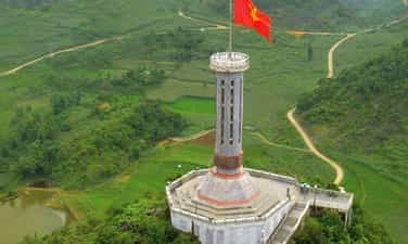
Lung Cu Flagpole
As the national flagpole, symbolizing the northernmost landmark of the Fatherland, Lung Cu flagpole is located at Lung Cu peak, also known as Dragon mountain peak (Long Son) in Dong Van district, Ha Giang province. This location is located at an altitude of about 1,470m above sea level. Lung Cu flagpole has a long history, having undergone many restorations and embellishments, the new octagonal flagpole with a height of over 30m was inaugurated on September 25, 2010. First built during the reign of Ly Thuong Kiet, the flagpole was initially made only of sa Moc tree. The column was rebuilt during the French colonial period in 1887. In the following years, such as 1992, 2000 and especially 2002, the flagpole continued to be restored and rebuilt many times with the size and scale increasing over time. In 2002, the flagpole was erected with a height of about 20m, the base and pedestal of the column are hexagonal shaped and at the base of the column are 6 reliefs depicting the surface of Dong Son bronze drums. According to the current design, the flagpole is built according to the Hanoi flagpole model but has a smaller size, height of 33.15m (10m more than the old flagpole) of which the base is 20.25m high, the outer diameter of the pole body is 20.25m high. 3.8m wide. The base and pedestal of the flagpole have 8 blue stone reliefs simulating the face pattern of the Dong Son bronze drum and motifs illustrating the stages through each period of the country's history, as well as its people. This location is also ranked as a national historical and scenic site, a symbol of affirming national sovereignty. Every year, Lung Cu flagpole welcomes a large number of tourists to explore. Source: Trang An Heritage
Tuyen Quang
5645 view
Rating : National monument

Trong Con sub-area
Trong Con Sub-area relic site in Bang Hanh commune, nearly 30 km from the center of Bac Quang district, has National Highway 279 running from Bac Quang district (Ha Giang) through Bang Hanh commune to Chiem Hoa district of Tuyen Quang province. . Since around 1939, the anti-imperialist movement has been rekindled here when comrade Pham Trung Ngu, a member of the Indochina Communist Party from Hoa An district, Cao Bang province, was assigned to Bang Hanh general, now in Bac Quang district (Ha Giang) to build a revolutionary base through teaching. In just a short time, comrade Pham Trung Ngu aroused the patriotism and revolutionary consciousness of the people in the region, denouncing French colonial rule. However, due to being discovered by the French colonialists, comrade Pham Trung Ngu had to withdraw from Bang Hanh to operate elsewhere. Implementing Comrade Ho Chi Minh's Directive, on June 1, 1945, comrade Le Quang Ba (aka Le Tam) and comrade Be Trieu (aka Hai Nam) commanded an armed propaganda team consisting of 54 soldiers. sent from Cao Bang to Bang Hanh district to propagate and build a revolutionary base. To ensure confidentiality and safety, comrades in the Command Committee were divided into groups to propagate and build the base. In just a short time, the armed propaganda team opened many short-term training classes, established guerrilla and self-defense teams, and national salvation organizations and named the area of operation "Zhong Con Sub-area". (name of hero Ly Tu Trong) includes Bang Hanh, Lien Hiep, Kim Ngoc, Vo Diem, Huu San communes. On June 24, 1945, representatives of the revolutionary government of communes in Trong Con Sub-area held a meeting at Thac Ve, Bang Hanh commune, to establish a revolutionary government and the general Viet Minh Front. Here, the people witnessed the revolutionary government burning with scarves and seals, eliminating the oppressive and exploitative regime of the feudal empire, organizing the people to produce, protecting order and security, build a new life. Since then, the revolutionary movement has grown stronger and quickly spread throughout Bac Quang district and surrounding areas. In August 1945, the revolutionary movement of ethnic people in Ha Giang province grew strong, together with the whole country rose up to seize the government and gain independence. 74 years have passed, the Thac Ve cliff is still there on the Lo river, engraved with the contributions of revolutionary soldiers and people of all ethnic groups on the left bank of the Lo river in Bac Quang district (Ha Giang) to the revolution. Together with the whole country, they rose up to seize power and gain independence. In 1996, the revolutionary historical relic site of Trong Con sub-area in Bac Quang district (Ha Giang) was recognized by the State as a national relic. Source: Vietnam News Agency
Tuyen Quang
5361 view
Rating : National monument

Cang Bac Me National Historical Relic Area
Bac Me Cang - a historical relic during the resistance war against the French, is located on the slopes of Dragon Mountain in Don Dien village, Yen Cuong commune, Bac Me district, Ha Giang province. Bac Me Cang was built by the French before 1938 during their occupation of Ha Giang. The French chose to build here because of its important strategic location, easy control over a large area, and convenient for French military activities during their occupation here. Bac Me Cang is built on the rugged, soaring rocky slopes. Behind is Dragon Mountain as a shield to protect this post, in front is the Gam River, making it easy to observe and cover the situation. Bac Me stretch was originally built by the French to control the arterial road connecting 3 northern mountainous provinces: Ha Giang, Tuyen Quang, and Cao Bang. When it was first built, it was used as a military camp to gather French soldiers and henchmen during the occupation of this area. The reason this place is called Cang Bac Me is because in French, Cang means "fort", and in the local language, Bac Me is "Pac Mia", which means hut door. Refers to the post where the troops were stationed as well as where the French colonial observation post was located. Bac Me stretch was built including a system of posts, information houses, and guard posts to serve their ruling purposes. From 1939 to 1942, Cang Bac Me was turned into a prisoner of war camp by the French to detain communist soldiers they captured. There are many of our patriotic revolutionary comrades detained here such as: comrades Xuan Thuy, Hoang Hui Nam, Hoang Bac Dung, Le Gian, Nguyen Hong, Dang Viet Chau... Taking advantage of the key terrain of the post built in the sacred forests and dangerous waters of this area. They arrested political prisoners and patriotic communist soldiers and imprisoned them here. Every day, those soldiers had to endure torture and labor in harsh and miserable conditions under their strict control in order to extinguish the patriotism and revolutionary will of their children. They are called Viet Cong. But all those hardships could not overcome the stubborn will of our people. The patriots turned pain into action, turning prisons into political schools. They established Party cells in prison, actively distributed leaflets and contacted people and soldiers outside. Faced with strong fighting activities of prisoners and people in the area, they were forced to change the place of detention with their communist comrades to other places. By 1992, Bac Me Cang was recognized as a national revolutionary historical relic. Over time this place has been greatly damaged. In 2003, the Department of Culture, Sports and Tourism of Ha Giang province coordinated with agencies in the province, along with Bac Me District, to restore a number of items of the relic such as: watchtower, prison, up and down road... Source: Ha Giang Department of Culture, Sports and Tourism
Tuyen Quang
8461 view
Rating : National monument

Ha Giang Ky Dai Relics
Ky Dai relic is located on March 26 Square in Nguyen Trai ward, Ha Giang city. Ky Dai is a place to commemorate the event of Uncle Ho visiting and talking with more than 16,800 ethnic minorities in Ha Giang province on March 27, 1961. On this occasion, Uncle Ho advised the people of all ethnic groups in Ha Giang province the following 8 main contents: First of all, all ethnic groups must unite closely, love and help each other like brothers. Second: People must strive to increase production, and practice thrift to make everyone warm, clothed, and fed. Third: To produce well, there must be enough water, lots of fertilizer and improved agricultural tools. Fourth: It is necessary to develop raising buffaloes, cows, pigs, chickens... which are a great source of profit and a source of fertilizer for upland fields. Fifth: Exploiting forest products, protecting forests and planting forest trees, growing fruit trees and medicinal trees. Sixth: People must pay attention to hygiene. To maintain health, they must eat and drink cleanly, wear clean clothes, and live cleanly. Health is good for productive labor. Seventh: People must try to eliminate illiteracy, must know how to read and write, then their business can progress. Eighth: The lives of the Cao Cao people are more difficult than those of people in other places. People at all levels and officials from the area to the district need to try their best to help the Cao Cao people overcome difficulties and build new life. Uncle Ho's advice penetrated deeply into the hearts of the people of Ha Giang ethnic groups in the cause of building and developing Ha Giang province in recent times. Ky Dai was recognized by the Ministry of Culture and Information (now the Ministry of Culture, Sports and Tourism) as a national monument in 1993. On March 30, 2001, the People's Committee of Ha Giang province started construction of the Square and cluster. The monument in front of Ky Dai's gate is named March 26 Square. The square includes the entire former stadium. In the middle of the square is a group of monuments called "Uncle Ho and his compatriots of all ethnic groups in Ha Giang". The statue model was created by sculptor Nguyen Phu Cuong and constructed by the Central Fine Arts Company. The project is over 11 meters high, includes 200 stone blocks, and weighs 600 tons. The image of Uncle Ho standing in the middle of a group of 7 characters, standing lovingly near him are two children of the Mong and Nung ethnic groups. Standing a little lower is a young girl of the Kinh and Dao ethnic groups. Behind are the images of a border guard soldier and a Tay officer, with radiant eyes as if wanting to record every teaching of Uncle Ho. The composition of the group of statues blends together, linked by a clear, vivid emotional thread. The formation of that rhythm is an intentional creative and symbolic treatment of the supporting block, giving viewers a feeling of the majestic space of Ha Giang's mountains and forests with layers of clouds flying and harmonizing with each other. with layers and layers of terraced fields.... With the advantage of the monument being placed in the square, the project has a monumental space with multi-directional, multi-dimensional perception. This is a cultural project - a gathering place for a large number of people to admire the majestic beauty of the project and conduct community activities. Ky Dai and March 26 Square have become places to visit for domestic and foreign tourists. It is a place for community cultural activities of people of all ethnic groups in Ha Giang. Source: Department of Culture, Sports and Tourism of Ha Giang Province
Tuyen Quang
8781 view
Rating : National monument

Nam Dan ancient stone beach
The Ancient Stone Beach relic is located in Nam Dan village, Nam Dan commune, Xin Man district. According to the local Nung language, "Nam Dan" means water source area. Nam Dan ancient stone field was ranked as a national relic by the Ministry of Culture, Sports and Tourism on February 21, 2008. Nam Dan ancient stone field was discovered in 2004 by scientists from the Institute of Archeology and Ha Giang Museum. The ancient stone relic site carved with drawings thousands of years ago is located in a wide valley. Unlike the ancient stone relics in Sa Pa (Lao Cai), Nam Dan ancient stone field is still little known, but the beauty of the drawings and the mysteries surrounding the stones are no less attractive and appealing. coil. These megalithic relics are located between the Tay Dan mountain range and the Nam Dan hill range, right next to the Nam Khoong stream. Many large sedimentary rocks lie along the stream banks with diverse and unique shapes. Some rocks are like a flat chess board, some are like a counter or a chair. On the surface and at the edges of the stone slab, the natural weathering state remains. People in the area call this area Na Lai (field of many words) because on some rocks there are engraved pictures and words. The engravings are very diverse, bringing their own beauty in the visual style of ancient art. In addition to more than 80 engravings and drawings, on the surface of the rock there are also about 80 holes, carved with an average diameter of 5 - 6cm, 1 - 2cm deep, the holes are mainly distributed at the western end of the rock. Each rock is a mystery, associated with thrilling stories bearing the mark of belief, demonstrating the effectiveness of praying to the gods of the ethnic minority people in the region. The stone field includes seven large stone slabs and two megaliths (extremely large rocks) engraved and painted with 79 shapes, including: six square inscriptions, two circular inscriptions, 40 circles, one square, Two rectangles, six chiseled parallel carvings similar to terraced fields, five images symbolizing women's vitality, the rest are human feet with dimensions equivalent to life size, with deeply engraved toes. On the rocks, the figure is in a position with both arms raised and legs spread... According to the village elders in Nam Dan: "There has been a long-standing custom of worshiping stones here, so no one dares to violate those mysterious ancient stones." Along with that, local people have also passed on to each other for many generations the legend that the ancient stone beach is the place where the gods keep "unrevealable heavenly secrets". The drawings on the rocks are considered by the people to be "heavenly temples" and this area is a "holy land" that no one here dares to take lightly. Up to now, in Vietnam, very few traces of prehistoric visual art have been found. According to scientists, the Nam Dan megalithic relic dates back about 2000 years. This may be the grave of a community leader or a sacred ground to worship gods, ancestors and prominent figures of the community. In addition, the Nam Dan megalithic relic is also likely related to the stone god worship of prehistoric residents. It can be said that Nam Dan ancient stone field has special value in culture, history, beliefs and high scientific research value. Source: Department of Culture, Information and Tourism of Ha Giang province
Tuyen Quang
5000 view
Rating : National monument

Dong Van ancient town
The name Dong Van is transliterated from the mandarin word "Tong Puon" meaning trading field. Historically this was the trading center of the entire large Dong Van district, the main hub for transporting opium to China. Quoc. The central area of Dong Van town in the past belonged to Dong Quan canton, Nguyen Binh district, Tuong Yen district, Ha Tuyen province. Afterwards, it merged into Bao Lac province, managed by a Tay mandarin named Nong in Bao Lac. When the French colonialists occupied, Dong Van was separated from Bao Lac. In 1887, the Dong Van area was occupied by the French colonialists and to facilitate colonial rule, they divided Dong Van into small continents, each headed by a ruling family. The land of Dong Van today It is managed by the Nguyen family, Mr. Nguyen Chan Quay. Previously, the Old Quarter was just a wild, sparsely populated valley. By the end of the 19th century and the beginning of the 20th century, when the French occupied Ha Giang, with the intention of turning this area into a busy trading center, the Old Quarter was built and formed. Looking down from above, 3 rows of market houses are arranged in a U shape, roofed with yin and yang tiles. When the market was first built, it was built with bamboo leaves. Elderly people currently living in the street recounted: During the Lunar New Year in 1923, there was a big fire in the Dong Van old town area. That fire burned down almost all the houses and shops thatched with thatch and bamboo leaves. The French colonialists at that time re-planned and sent a number of Tay and Mong people to hire workers from China to design and build today's market area. The ancient market consists of 15 market halls, divided into 3 symmetrical rows forming a U-shaped architecture. The pillars are large stone pillars 3 or 4 people thick, carved meticulously by human hands. According to collected documents, there are currently 2 houses in Dong Van Old Town that are over 100 years old. In addition, in this neighborhood there are also a number of villas of other local companies such as the villas of Tay ethnic people Nguyen Dinh Cuong (1828-1865) and the Nguyen family, which have now been demolished, leaving only the old floor. . From 1923 to 1940, the houses in the Dong Van street area were built by Sichuan workers and local workers. Regarding architecture: Most of the ancient houses on Dong Van Street were designed and built by Chinese and local craftsmen, so they have very common nuances, such as: the foundations and porches are built of green stone. , the walls are made of clay mixed with lime, molasses and paper or fired bricks or rustic bricks, so they are durable. Doors and windows are designed as arched or square doors with stone or brick cladding in the door frame. House columns were built of burnt bricks or solid wood and pine. Currently, some houses in the neighborhood still retain elaborately carved stone column bases in many different shapes, mainly 4-sided or circular pillar with the appearance of a poppy flower. In the house, the floors and second floor are all paneled with precious woods. The houses are designed to be built in the style of 3 rooms and 2 roofs, with yin and yang tile roofs or square houses in the middle of the yard with paved stones (like the old People's Committee house). Ancient houses in Dong Van Old Quarter were built with the same decoration and arrangement. The middle space is an important space used to place the altar, right at the entrance and also a place to receive guests, behind the altar of the middle room and the two rooms. Next to it is the bedroom, the middle room behind the altar is the room of the elders in the family, the two sides are the rooms of the children and grandchildren. If the house is large, you can have a separate kitchen or stairs to the second floor depending on how you arrange it. each family's mindset The houses have an imposing appearance and delicate softness of wood and stone carvings, a harmonious combination of ancient Chinese architecture and Vietnamese art. Go to the rocky plateau to visit Dong Van ancient town, visit the highland market to immerse yourself in the indigenous culture. It can be said that the market is the place that most clearly shows the cultural identity of the people here. The highland market is not only a place for trade but also a meeting place for boys and girls. This is truly a festival for the people of the mountainous frontier. Every Sunday when the market The session was held, a noisy, bustling and boisterous atmosphere, boys and girls with colorful dresses came to the market. It can take them half a day to get to the market. Some people go to the market to buy and sell products. Wives and mothers go to the market to shop, husbands go to the market to socialize, drink wine and eat Thang Co, and young men and women go to the market to socialize and find partners. These are bold expressions of the market cultural identity of the rocky plateau. We can see somewhere the image of a wife standing under an umbrella waiting for her drunk husband to sleep at the corner of the market or on the sidewalk. It is a beautiful image imbued with identity that cannot be found anywhere else. With ancient and mossy features that have survived the flow of time, Dong Van Old Town was recognized as a historical, cultural, and artistic architectural relic in 2010. Source: Ha Giang Provincial Party Committee Propaganda Department
Tuyen Quang
4821 view
Rating : National monument

Cat King's Palace
King Meo's Mansion, also known as Vuong's Mansion, is located in Sa Phin valley (Xa Phin), Lung Phin commune, Dong Van district, Ha Giang province, about 125km from the city center and about 125km from the city center. The famous Dong Van stone plateau is only 15km away. This ancient house is associated with the life and career of two Mong people, the Meo King Vuong Chinh Duc and Vuong Chi Sinh (or Vuong Chi Thanh). Mr. Vuong Chinh Duc (1886 - 1962) was the head of the feudal land government in the mountainous areas of the Mong people, so he was also known by the powerful name of King Meo. His son, who followed the revolutionary path, thanks to his contributions to the country, was elected as a National Assembly deputy for the first two terms. Construction began in 1898 and was officially completed in 1907, costing a huge sum of 150,000 Indochina white silver coins, equivalent to 150 billion VND today. The mansion was designed and built by Chinese Yunnan workers in combination with Mong ethnic people, creating a project larger than 1200m2 on an area of about 3000m2. Thanks to its long history and indisputable cultural value, King Cat Palace was ranked a national monument by the Ministry of Culture, Sports and Tourism in 1993, after nearly a century of existence. In addition, this mansion also took up to 5 years to start construction, all were built with human power and did not use any mechanical means. King Cat's mansion is located at the foot of a valley surrounded above by a high land. With this type of terrain, the entire structure is protected by mountain arcs called turtle shell positions, providing very good defense support during times of fierce war. After more than a hundred years of existence, everything in the mansion is still as intact as the first day. The architecture inside the mansion is extremely unique, the crystallization of three different cultures including the Mong, French and Chinese. The project includes 4 horizontal houses, 6 vertical houses divided into 3 areas: front palace (for guards and slaves), middle palace and rear palace (place to live and work) with 64 small rooms divided into 2 floors. . To meet the criteria of solidity, the builders used green stone to help the mansion stand firm against enemies and time. The roofs, walls and pillars are made of wood to add majesty and flexibility to the rooms. Another material used is terracotta for building tile roofs to make shaping easier but no less sturdy. To this day, the Cat King Palace is one of the few buildings that meets all the requirements for a place to live, work and become a defense base whenever a war occurs. Despite the combination of three cultures in architecture, many people commented that the Vuong family mansion is extremely harmonious, flexible and rhythmic as if forming a unified block without being restrictive or forced. In addition, although it is a project built on a land area of up to 3,000 square meters, the mansion is not as large or massive as many people imagine because it is composed of small subdivisions, with a simple, rusticity of folk architectural culture. The design with the principle of low inside and high outside makes the overall Villa even closer to the surrounding landscape. In general, most of the furniture and items associated with King Cat when he was alive have been kept and well preserved until today. Only a few chairs and wooden furniture were made of stone pine, which was later replaced by our government with ironwood and crushed wood to prevent it from gradually disappearing over time. The wooden structures have a rich local cultural identity by carving native flower patterns such as peaches, poppies... The pillars are crafted to resemble the fruit of the opium poppy, a plant that King Cat does business to make money to build a mansion. Some Western-influenced items in this project include a stone goat milk bathtub, glass shutters next to the fireplace, and the entrance is made of marble connected by a frame. Iron flowers are bold in French architecture. Source: Ha Giang Tourism Newspaper
Tuyen Quang
5605 view
Rating : National monument
Outstanding monuments
See all
Relics of French Fort and Lung Ho citadel wall
The French Fort relic and Lung Ho citadel wall are located in Lang Qua village, Lung Ho commune, Yen Minh district, Ha Giang province. The fortress and the city wall are two separate areas and are located about 2km apart, at an altitude of 742m above sea level. The French Fort and Lung Ho wall relics are 106km north of Ha Giang city. According to French documents, in 1907 Duong Thuong land belonged to Dong Minh canton, Yen Minh commune, Ha Giang province. During the inspection trip to the Dai Mien, Tieu Mien, Yen Minh, Yen Dinh, Du Gia, and Duong Thuong regions of Lieutenant Colonel Boifacy, commander of the 3rd military force, in report No. 1165, September 1913, this land " needs to be monitored and that is why there must be Duong Thuong post..." After this inspection trip, the work of planning to build a new post was gradually carried out. The old Duong Thuong post, now Lung Ho post, was built and completed in the years 1935 - 1940. The work of building the post was extremely difficult, they forced people in the surrounding area to work as laborers and servants. Carrying stones and water for construction, anyone who did not comply was beaten or shot to death. Citadel wall: The citadel wall is nearly 2km away from the fort and is arranged based on natural conditions along the mountain slopes on both sides of the unique road connecting Lung Ho and Yen Minh with the purpose of controlling goods, people and horses in this area, according to the report. The unit will contact the station about 2km away. The main material for building the wall is mountain stone, taken from the construction site and surrounding areas in many different sizes. The mortar used to build is mainly sand mixed with lime, without cement. . Lung Ho Fort: The fort was built on high, fairly flat land facing East - West. The length of the surrounding wall is nearly 200m and is equipped with firing positions. The firing positions all have observation holes on the outside. The main material for building the wall is mountain stone, taken from the construction site and surrounding areas in many different sizes. The mortar used to build is mainly sand mixed with lime, without cement. . The design of the station includes a horizontal block and a vertical row of houses on the west side; The area of vertical houses and watchtowers in the East; Between the East and West areas is a large area of land. In general, many construction items were dilapidated and damaged, and almost the entire roof of the vertical and horizontal rows of houses were dismantled. Militarily, Lung Ho Fort and wall are large-scale works with an important position blocking the road from Lung Ho to Duong Thuong, and at the same time preventing revolutionary propaganda activities in our Duong Thuong region during the period. this time. The work is evidence of a historical period of French occupation and activities in the remote, mountainous area of Ha Giang province. Under the control and enslavement of the French colonialists in the Duong Thuong area, people's lives fell into poverty. Implementing the leadership resolutions of the Northern Region Party Committee and the Cao - Bac - Lang Interprovincial Party Committee. “At the end of 1944, comrade Viet Hung carried out the task of opening up the communication route from Cao Bang - Bac Can - Ha Giang to Yunnan (China) to welcome officers and transport weapons from abroad to the country. Comrade Viet Hung came to Lung Ho, Duong Thuong built a base, using Duong Thuong as a base, wherever Viet Minh cadres went, they received support from their compatriots. On March 9, 1945, the Japanese fascists overthrew France. In Duong Thuong (Yen Minh), Colonel Dao Van At panicked and fled the station. Seizing that opportunity, Viet Minh officers in Duong Thuong held an emergency meeting, occupied Duong Thuong station, destroyed the warehouse, took corn and rice to distribute to the people and set up a guard station outside the base area, which was carried out very urgently. On March 16, 1945, we captured Duong Thuong station, owned and completely controlled the Duong Thuong area, from here Viet Minh cadres spread to the base to lead the movement. Along with Sung Chu Da relic site, Duong Thuong revolutionary base, Mau Long cave is recognized as a national scenic spot, Du Gia national park and Gau Tao, Long Tong, Moon Bridge, and Cap Sac Festivals. , Thuong Tho... Notably, the Tay People's Fish Festival is held in Mau Due commune. Along with the direction of the district and province in the coming time, the Lung Ho Fort and wall relics will continue to be attractive destinations for tourists when coming to Yen Minh. Source: Ha Giang Provincial Party Committee Propaganda Department
Tuyen Quang
9226 view
Rating : National monument

Ha Giang Ky Dai Relics
Ky Dai relic is located on March 26 Square in Nguyen Trai ward, Ha Giang city. Ky Dai is a place to commemorate the event of Uncle Ho visiting and talking with more than 16,800 ethnic minorities in Ha Giang province on March 27, 1961. On this occasion, Uncle Ho advised the people of all ethnic groups in Ha Giang province the following 8 main contents: First of all, all ethnic groups must unite closely, love and help each other like brothers. Second: People must strive to increase production, and practice thrift to make everyone warm, clothed, and fed. Third: To produce well, there must be enough water, lots of fertilizer and improved agricultural tools. Fourth: It is necessary to develop raising buffaloes, cows, pigs, chickens... which are a great source of profit and a source of fertilizer for upland fields. Fifth: Exploiting forest products, protecting forests and planting forest trees, growing fruit trees and medicinal trees. Sixth: People must pay attention to hygiene. To maintain health, they must eat and drink cleanly, wear clean clothes, and live cleanly. Health is good for productive labor. Seventh: People must try to eliminate illiteracy, must know how to read and write, then their business can progress. Eighth: The lives of the Cao Cao people are more difficult than those of people in other places. People at all levels and officials from the area to the district need to try their best to help the Cao Cao people overcome difficulties and build new life. Uncle Ho's advice penetrated deeply into the hearts of the people of Ha Giang ethnic groups in the cause of building and developing Ha Giang province in recent times. Ky Dai was recognized by the Ministry of Culture and Information (now the Ministry of Culture, Sports and Tourism) as a national monument in 1993. On March 30, 2001, the People's Committee of Ha Giang province started construction of the Square and cluster. The monument in front of Ky Dai's gate is named March 26 Square. The square includes the entire former stadium. In the middle of the square is a group of monuments called "Uncle Ho and his compatriots of all ethnic groups in Ha Giang". The statue model was created by sculptor Nguyen Phu Cuong and constructed by the Central Fine Arts Company. The project is over 11 meters high, includes 200 stone blocks, and weighs 600 tons. The image of Uncle Ho standing in the middle of a group of 7 characters, standing lovingly near him are two children of the Mong and Nung ethnic groups. Standing a little lower is a young girl of the Kinh and Dao ethnic groups. Behind are the images of a border guard soldier and a Tay officer, with radiant eyes as if wanting to record every teaching of Uncle Ho. The composition of the group of statues blends together, linked by a clear, vivid emotional thread. The formation of that rhythm is an intentional creative and symbolic treatment of the supporting block, giving viewers a feeling of the majestic space of Ha Giang's mountains and forests with layers of clouds flying and harmonizing with each other. with layers and layers of terraced fields.... With the advantage of the monument being placed in the square, the project has a monumental space with multi-directional, multi-dimensional perception. This is a cultural project - a gathering place for a large number of people to admire the majestic beauty of the project and conduct community activities. Ky Dai and March 26 Square have become places to visit for domestic and foreign tourists. It is a place for community cultural activities of people of all ethnic groups in Ha Giang. Source: Department of Culture, Sports and Tourism of Ha Giang Province
Tuyen Quang
8781 view
Rating : National monument

Cang Bac Me National Historical Relic Area
Bac Me Cang - a historical relic during the resistance war against the French, is located on the slopes of Dragon Mountain in Don Dien village, Yen Cuong commune, Bac Me district, Ha Giang province. Bac Me Cang was built by the French before 1938 during their occupation of Ha Giang. The French chose to build here because of its important strategic location, easy control over a large area, and convenient for French military activities during their occupation here. Bac Me Cang is built on the rugged, soaring rocky slopes. Behind is Dragon Mountain as a shield to protect this post, in front is the Gam River, making it easy to observe and cover the situation. Bac Me stretch was originally built by the French to control the arterial road connecting 3 northern mountainous provinces: Ha Giang, Tuyen Quang, and Cao Bang. When it was first built, it was used as a military camp to gather French soldiers and henchmen during the occupation of this area. The reason this place is called Cang Bac Me is because in French, Cang means "fort", and in the local language, Bac Me is "Pac Mia", which means hut door. Refers to the post where the troops were stationed as well as where the French colonial observation post was located. Bac Me stretch was built including a system of posts, information houses, and guard posts to serve their ruling purposes. From 1939 to 1942, Cang Bac Me was turned into a prisoner of war camp by the French to detain communist soldiers they captured. There are many of our patriotic revolutionary comrades detained here such as: comrades Xuan Thuy, Hoang Hui Nam, Hoang Bac Dung, Le Gian, Nguyen Hong, Dang Viet Chau... Taking advantage of the key terrain of the post built in the sacred forests and dangerous waters of this area. They arrested political prisoners and patriotic communist soldiers and imprisoned them here. Every day, those soldiers had to endure torture and labor in harsh and miserable conditions under their strict control in order to extinguish the patriotism and revolutionary will of their children. They are called Viet Cong. But all those hardships could not overcome the stubborn will of our people. The patriots turned pain into action, turning prisons into political schools. They established Party cells in prison, actively distributed leaflets and contacted people and soldiers outside. Faced with strong fighting activities of prisoners and people in the area, they were forced to change the place of detention with their communist comrades to other places. By 1992, Bac Me Cang was recognized as a national revolutionary historical relic. Over time this place has been greatly damaged. In 2003, the Department of Culture, Sports and Tourism of Ha Giang province coordinated with agencies in the province, along with Bac Me District, to restore a number of items of the relic such as: watchtower, prison, up and down road... Source: Ha Giang Department of Culture, Sports and Tourism
Tuyen Quang
8461 view
Rating : National monument

Kim Binh relic site
The Second National Congress Relic of the Party (Kim Binh Relic Area), includes 52 points, distributed in 4 communes: Kien Dai, Kim Binh, Vinh Quang, Linh Phu, Chiem Hoa district , Tuyen Quang province. The relic site of the Second National Congress of the Party is a place that marks many important historical events of the nation, such as: The National Congress unifying the Viet Minh Front and the Lien Viet Front into the Inter-Vietnamese Front. Vietnam, People's Alliance Conference of the three countries Vietnam - Cambodia - Laos, Nguyen Ai Quoc School (predecessor of the Ho Chi Minh National Academy of Politics) opens course III, Congress of Emulating Heroes, Soldiers and Cadres the first national model. 1. Relic site of the Party Central Committee and Government's working location, Kien Dai commune. Kien Dai commune is surrounded by a system of high hills and mountains (accounting for 3/4 of the area), the terrain is extremely dangerous, mobile, "convenient to advance, convenient to retreat", is the border area between Tuyen Quang and Bac Kan provinces. . Transportation is mainly by trails and railways (dating back to the French colonial period). Kien Dai base area is covered with a rich and diverse layer of vegetation, convenient for exploitation and construction of camps, houses, warehouses, trenches, and fortifications. Many high mountains surround villages and hamlets, forming a solid wall. There are many caves and caves in the mountain, very convenient for taking shelter when there is an alarm. The people here are mostly Tay and Dao ethnic people, with a spirit of patriotism and early revolutionary enlightenment. With a location that ensures safety, secrecy, and convenient transportation and communication, Kien Dai was the residence and working place of leaders and many central agencies during the period from 1948 - 1952. 2. Relic area of the Second National Congress of the Party, Kim Binh commune. At the end of 1950, after carefully studying the terrain of Kim Binh commune, the Party Central Committee decided to choose the Na Loang hill area, in Bo Cung village, as the place to hold the Party's Second National Congress. Na Loang Hill is located in the center of Bo Cung village, surrounded by many high mountain ranges, such as Pu Choong, Pu Mi, Pu Meo, Trai Face, Kham Khuat, forming a solid and convenient wall. to place observatories and air defense battlefields. The hill is bowl-shaped, the top is quite wide and flat, convenient for building houses and traveling. At the foot of the hill there is Co Linh stream flowing through, which is a source of water for the delegates' daily activities. From Na Loang hill, there are many convenient paths to areas in the Safety Zone. 3. Guard station to protect central agencies, Chinh street, Vinh Quang commune The guard station is a three-room dirt house built with wooden pillars, a roof thatched with palm leaves and double-woven bamboo walls, with one door and two windows. The house is about 3m long, about 2m wide, inside there is a set of tables and chairs to serve the security guard. Currently, only the site remains. 4. Location Na Ma, Pac Hop village, Linh Phu commune The small shack about 20m from the stilt house of Mr. Ha Van Hop's family, where President Ho Chi Minh and comrade Truong Chinh rest, is about 7m long and about 3m wide. The shack is made of bamboo, the roof is thatched with palm leaves, and the walls are double-woven bamboo. The stilt house of Mr. Ha Van Hop's family, where Comrade Pham Van Dong stayed overnight, is a stilt house with 3 rooms and 2 wings, made of wooden pillars, roofed with palm leaves, surrounded by double woven bamboo walls. , there are 2 stairs up and down. Currently, only the site remains. Artifacts of the Second National Congress of the Party relic site are kept at Tuyen Quang Provincial Museum (20 artifacts) such as: tables, chairs in the hall, storage boxes for construction, rice boxes serving the Congress, lunch boxes, and document boxes for delegates. At the Kien Dai Relic Area, there are artifacts: the desk and chair sets of comrade Truong Chinh and comrade Pham Van Dong... Ho Chi Minh National Academy of Politics still retains a number of artifacts such as: desks and chairs. , President Ho Chi Minh's working chair during the Congress... The Second National Congress of the Party took place from February 11 to 19, 1951, which was also the occasion for people of all ethnic groups in Kim Binh commune to organize the Long Tong festival. Therefore, the monument has a close connection with the festival. The relic site of the Second National Congress of the Party has great significance in the work of educating patriotic traditions and revolutionary heroism. With typical special values, the historical relic site of the Party's 2nd National Congress (Chiem Hoa district, Tuyen Quang province) was ranked by the Prime Minister as a Special National Monument. farewell on December 22, 2016). Source: Tuyen Quang province electronic information portal
Tuyen Quang
8359 view
Rating : Special national monument

Tan Trao Banyan Tree
Tan Trao banyan tree relic in Tan Lap village, Tan Trao commune, Son Duong district, Tuyen Quang province. Tan Trao banyan tree is a historical symbol of Tan Lap village, where important events took place during the resistance war against the French of the Vietnamese people. This banyan tree is not only the protector of the people here but also a living witness to the heroic days of Tan Trao's army and people. Under the Tan Trao banyan tree, on the afternoon of August 16, 1945, General Vo Nguyen Giap read the Military Order No. witnessed by all Viet Bac ethnic people and 60 national delegates. From then until now, Tan Trao banyan tree has become a revolutionary symbol of the Capital of Tuyen Quang Liberation Zone. The Tan Trao banyan tree has two towering branches that people call the banyan tree and the banyan tree. Both trees are located 10mm apart and have very lush branches and leaves. Through many historical events, the banyan tree gradually ages and weakens. In 1993, due to the impact of a storm, the "banyan tree" fell, leaving only a small branch. The "banana tree" cannot avoid the law of "birth and death", gradually showing bad signs, the leaves turn yellow, and some tops die. By 2008, the Tan Trao banyan tree had only one left branch facing the Northeast of the "banana tree" that was still alive but was not growing well, the main root of the tree was almost dead. Faced with that urgent situation, the local government has coordinated with organizations and businesses to come up with plans to care and revive the Tan Trao banyan tree. With much effort, after 2 years the Tan Trao banyan tree has gradually recovered, more young shoots have appeared, signaling that life will flourish strongly. And to this day, the "banyan tree" has developed into 2 root clusters consisting of 38 large and small roots, with a wide canopy that radiates cool green shade. The small branch of the "banyan tree" has also recovered and grown into a lush new cluster of trees. Tan Trao banyan tree relic is located in the Tan Trao special national relic area of Tuyen Quang province. Source: Tuyen Quang Tourism
Tuyen Quang
7948 view
Rating : Special national monument

Khe Lau Victory Relics
Khe Lau is the intersection of Gam River and Lo River in Thang Quan commune, Yen Son district, Tuyen Quang province. This place also has many other names such as Luong junction, Cua Song or Hon Lau. With the rugged terrain, both banks of the river have dense reed hills and being near the foot of the mountain created favorable conditions for our troops to ambush and attack the enemy. From November 3, 1947, French troops began to withdraw from Champa to Tuyen Quang town by both waterway and road. The soldiers of Regiment 112 cut through the forest and crossed back to Yen Nguyen to coordinate with local militia and guerrillas to set up an ambush from the foot of Ga Pass to Ca bridge. Artillery was urgently dispatched from Yen Binh to ambush enemy ships at Hon Lau. At 2:00 p.m. on November 10, 1947, the enemy's train consisting of 2 L C T and 1 canoe carrying 200 European and African soldiers from Chiem Hoa headed to Hon Lau. Our artillery continuously opened fire. Both enemy L C Ts were hit and caught fire. The enemy's canoe fled but was also hit. French soldiers ran ashore and were immediately shot and destroyed by militia and guerrillas. The battle of Khe Lau took place for more than 1 hour, our troops destroyed more than 200 enemy soldiers, sank 2 warships, and 1 canoe. The Khe Lau victory is considered one of the 10 major battles in the Viet Bac Autumn-Winter campaign in 1947. The late Lieutenant General Pham Hong Cu, former Deputy Director of the General Political Department of the Vietnam People's Army, former Political Commissar of the Binh Ca Battalion once affirmed that during the Viet Bac Fall-Winter campaign in 1947, Tuyen Quang contributed to Victory on the Lo River front in 2 battles. The first battle was the Battle of Binh Ca and the last battle was the Battle of Khe Lau. Uncle Ho said, "The enemy is strong in two pincers. If we break them, the umbrella they hold over Viet Bac will collapse into a torn umbrella." The army and people of Tuyen Quang contributed to breaking the French waterway army, contributing greatly to the Viet Bac Fall-Winter victory in 1947. Destroying the strategic intention of fighting quickly, winning quickly, forcing them to switch to fighting for a long time. to deal with us, contributing to bringing our nation's resistance to a new era. With this victory, our armed forces have grown more and more, and the Viet Bac base has become a symbol of trust and victory. Unable to carry out their plot, the French colonialists were forced to withdraw from Viet Bac. In the process of fleeing, they were blocked and attacked by our troops, consuming much of their energy. In mid-December 1947, Tuyen Quang was clear of invaders. During the Viet Bac Fall-Winter campaign of 1947, the army and people of Tuyen Quang fought 48 battles, including 30 independent battles, 18 battles in coordination with the main army, destroying 1,300 enemies, shooting and missing 10. canoes, warships, destroyed an airplane, confiscated many weapons, military equipment, and military supplies. The army and people of Tuyen Quang have successfully completed the task of draining enemy forces, contributing to protecting the safety and secrecy of Uncle Ho's residence and the headquarters of the resistance. On December 23, 1947, in Tuyen Quang town, a ceremony to celebrate the victory of Viet Bac Fall-Winter 1947 took place and was honored to be replaced by Comrade Vo Nguyen Giap - General Commander of the People's Army and Vietnam Militia and Self-Defense Force. The Government commends the merits of the soldiers and people of Viet Bac. Source: People's Newspaper
Tuyen Quang
7201 view
Rating : National monument

Da Ban historical site
Lang Ngoi - Da Ban historical relic site is a historical place known for the love of solidarity and sharing between Vietnam and Laos. The Lao revolutionary relic is located in Lang Ngoi - Da Ban village, My Bang commune, Yen Son district, Tuyen Quang province. The relics are distributed in two areas: Lang Ngoi area and Da Ban area. The Lang Ngoi area includes relics: Neo Lao Itxala Congress Hall; Comrade Kaysone Phomvihan's residence and work place; Prince Souphanuvong's residence and work; where the Lao army unit lives and works. The entire relic site is located on Go Tre hill and To hill in Lang Ngoi village, My Bang commune, Yen Son district, Tuyen Quang province. The area that has been zoned for protection is: 1,500m2. Here, on August 13, 1950, the National Congress of the Lao Resistance Front took place. More than 100 delegates attended the Congress on behalf of the people of Lao tribes. The Congress elected the Lao Resistance Government led by Prince Souphanu-vong as Prime Minister; Comrade Kaysone Phomvihan, became Minister of Defense (later General Secretary of the Lao People's Revolutionary Party) and elected the Central Executive Committee of the Free Lao Front (Neo Lao Issala) to push Strengthen the resistance against the French colonialists, gain independence and unification for Laos, and build a prosperous and happy life for the people. Through historical changes, the vestiges have been gradually eroded. In order to preserve the historical values, Tuyen Quang Department of Culture, Sports and Tourism has implemented a project to restore and embellish the relic area. Lao revolutionary national history. The project has restored the houses and offices of comrade Kaysone Phomvihane and Prince Souphanuvong; Hall house; restore and embellish the tunnel and trench system; renovate Da Ban cave entrance; renovate the overall beer house; Build a solid bridge across the stream leading to the relic site; Build a house for the Monument Management Board... To further promote the special cultural and historical values of the Lao Revolution national relic site, the Party Committee, government and people of all ethnic groups in Tuyen Quang province have well performed the task of managing and preserving preserve, conserve, embellish and effectively promote the historical values of the relic site; making the Lao revolutionary national historical relic site in Tuyen Quang truly become a symbol of special solidarity and friendship between the two Parties, States and people of Vietnam and Laos. At the same time, do a good job of educating revolutionary traditions, especially for the young generation of the two countries to continue to nurture, nurture and make the relationship between Vietnam and Laos forever close and vibrant. Source: Department of Foreign Information
Tuyen Quang
5671 view
Rating : National monument

Lung Cu Flagpole
As the national flagpole, symbolizing the northernmost landmark of the Fatherland, Lung Cu flagpole is located at Lung Cu peak, also known as Dragon mountain peak (Long Son) in Dong Van district, Ha Giang province. This location is located at an altitude of about 1,470m above sea level. Lung Cu flagpole has a long history, having undergone many restorations and embellishments, the new octagonal flagpole with a height of over 30m was inaugurated on September 25, 2010. First built during the reign of Ly Thuong Kiet, the flagpole was initially made only of sa Moc tree. The column was rebuilt during the French colonial period in 1887. In the following years, such as 1992, 2000 and especially 2002, the flagpole continued to be restored and rebuilt many times with the size and scale increasing over time. In 2002, the flagpole was erected with a height of about 20m, the base and pedestal of the column are hexagonal shaped and at the base of the column are 6 reliefs depicting the surface of Dong Son bronze drums. According to the current design, the flagpole is built according to the Hanoi flagpole model but has a smaller size, height of 33.15m (10m more than the old flagpole) of which the base is 20.25m high, the outer diameter of the pole body is 20.25m high. 3.8m wide. The base and pedestal of the flagpole have 8 blue stone reliefs simulating the face pattern of the Dong Son bronze drum and motifs illustrating the stages through each period of the country's history, as well as its people. This location is also ranked as a national historical and scenic site, a symbol of affirming national sovereignty. Every year, Lung Cu flagpole welcomes a large number of tourists to explore. Source: Trang An Heritage
Tuyen Quang
5645 view
Rating : National monument

Mac Dynasty Citadel Relics (Tuyen Quang Citadel)
Tuyen Quang Citadel (also known as Mac Dynasty Citadel) is located between Xuan Hoa and Tam Co neighborhoods, in Tan Quang ward, Tuyen Quang city, built around 1533-1548. The citadel was built in a square shape, each side is 275m long, the wall is 3.5m high, and the thickness at the top of the citadel is 0.8m. In the middle of each side of the citadel there is a semicircular door opening to the four directions east, west, south, and north. A tower was built above the door and the roof was covered with scale tiles. Inside the citadel wall, there is a small path for refueling ammunition, first aid, and transporting wounded. Bricks are made of laterite containing iron ore, which is very hard. At the outer edge of the citadel is a layer of deep, flooded moats. At the beginning of the Nguyen Dynasty, the citadel was repaired, reinforced, and built with small bricks. In the citadel, slightly to the north, there is Tho Son mountain, nearly 50m high, steep, very convenient for observing and defending when surrounded. Located on the banks of the Lo River, located on a convenient transportation axis, the terrain and structure make the citadel an important military position. There were many historical events that took place in the Mac Dynasty citadel: In 1884, ethnic people led by Lanh Chan and Doc Thinh along with Luu Vinh Phuc's army besieged the French army in the citadel from August 1884 to April 1885, blocking supply ships and digging many tunnel, use explosives to destroy it. Out of a total of 600 enemies, 200 were killed and more than 300 were injured. At dawn on August 17, 1945, under the command of the Provincial Uprising Committee, the Liberation Army and local self-defense quickly captured the provincial governor's palace, security camp, post office, and treasury department, leaving only Tuyen Quang citadel was camped by Japanese troops. On August 20, the Liberation Army both blocked the Japanese army from Ha Giang and concentrated its forces to attack the citadel, organizing a mass march to show its might. On August 21, the Japanese army was forced to surrender. On March 20, 1961, at the stadium at the foot of Tho Son mountain, Tuyen Quang people held a meeting to welcome President Ho Chi Minh to visit and work. Tuyen Quang Citadel Relics was ranked as a National Relic on August 30, 1991. Source: Tuyen Quang Electronic Newspaper
Tuyen Quang
5628 view
Rating : National monument

Cat King's Palace
King Meo's Mansion, also known as Vuong's Mansion, is located in Sa Phin valley (Xa Phin), Lung Phin commune, Dong Van district, Ha Giang province, about 125km from the city center and about 125km from the city center. The famous Dong Van stone plateau is only 15km away. This ancient house is associated with the life and career of two Mong people, the Meo King Vuong Chinh Duc and Vuong Chi Sinh (or Vuong Chi Thanh). Mr. Vuong Chinh Duc (1886 - 1962) was the head of the feudal land government in the mountainous areas of the Mong people, so he was also known by the powerful name of King Meo. His son, who followed the revolutionary path, thanks to his contributions to the country, was elected as a National Assembly deputy for the first two terms. Construction began in 1898 and was officially completed in 1907, costing a huge sum of 150,000 Indochina white silver coins, equivalent to 150 billion VND today. The mansion was designed and built by Chinese Yunnan workers in combination with Mong ethnic people, creating a project larger than 1200m2 on an area of about 3000m2. Thanks to its long history and indisputable cultural value, King Cat Palace was ranked a national monument by the Ministry of Culture, Sports and Tourism in 1993, after nearly a century of existence. In addition, this mansion also took up to 5 years to start construction, all were built with human power and did not use any mechanical means. King Cat's mansion is located at the foot of a valley surrounded above by a high land. With this type of terrain, the entire structure is protected by mountain arcs called turtle shell positions, providing very good defense support during times of fierce war. After more than a hundred years of existence, everything in the mansion is still as intact as the first day. The architecture inside the mansion is extremely unique, the crystallization of three different cultures including the Mong, French and Chinese. The project includes 4 horizontal houses, 6 vertical houses divided into 3 areas: front palace (for guards and slaves), middle palace and rear palace (place to live and work) with 64 small rooms divided into 2 floors. . To meet the criteria of solidity, the builders used green stone to help the mansion stand firm against enemies and time. The roofs, walls and pillars are made of wood to add majesty and flexibility to the rooms. Another material used is terracotta for building tile roofs to make shaping easier but no less sturdy. To this day, the Cat King Palace is one of the few buildings that meets all the requirements for a place to live, work and become a defense base whenever a war occurs. Despite the combination of three cultures in architecture, many people commented that the Vuong family mansion is extremely harmonious, flexible and rhythmic as if forming a unified block without being restrictive or forced. In addition, although it is a project built on a land area of up to 3,000 square meters, the mansion is not as large or massive as many people imagine because it is composed of small subdivisions, with a simple, rusticity of folk architectural culture. The design with the principle of low inside and high outside makes the overall Villa even closer to the surrounding landscape. In general, most of the furniture and items associated with King Cat when he was alive have been kept and well preserved until today. Only a few chairs and wooden furniture were made of stone pine, which was later replaced by our government with ironwood and crushed wood to prevent it from gradually disappearing over time. The wooden structures have a rich local cultural identity by carving native flower patterns such as peaches, poppies... The pillars are crafted to resemble the fruit of the opium poppy, a plant that King Cat does business to make money to build a mansion. Some Western-influenced items in this project include a stone goat milk bathtub, glass shutters next to the fireplace, and the entrance is made of marble connected by a frame. Iron flowers are bold in French architecture. Source: Ha Giang Tourism Newspaper
Tuyen Quang
5605 view
Rating : National monument